TrailDamage.com

Photos, videos and information about 4x4 trails in Colorado and Utah

  • Trails
    • Colorado
    • Utah
  • Reports
    • Featured Photos
    • Featured Videos
    • Reports Calendar
  • Members
  • Search
  • Trail Damage Winners
  • FAQ
  • Community
  • Upcoming Events
  • Membership
  • Log In
  • Facebook
  • Instagram
  • RSS
  • Twitter
  • YouTube

Lathrop Canyon 130830

August 30, 2013 by Monica

Lathrop Canyon

Trail Run on August 30, 2013
Report and photos by Monica I., Trail Leader
View trail information for Lathrop Canyon

Walt S.
Gray 2022 Jeep Wrangler Unlimited Rubicon 392
Ben P.
Green 2012 Jeep Wrangler Unlimited Rubicon
Les L.
Gray 2006 Nissan Frontier
Monica I.
Red 2010 Jeep Wrangler Rubicon
Jeffrey M.
Khaki 2006 Jeep Wrangler Unlimited Rubicon
Matt K.
White 2016 Jeep Wrangler Unlimited Rubicon
Julie M.
Green 2012 Jeep Wrangler Unlimited Rubicon

We spent the night at the Airport Campground on the White Rim trail, a spot very close to the trailhead for Lathrop Canyon. That meant we were descending into the canyon first thing in the morning. The temperatures were nice but it promised to be hot during the main part of the day.

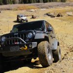
The initial descent is fun and steep. Part of it was washed out a bit and it would have been challenging for a stock SUV. We didn't have any issues, though.

We followed the trail as it weaved back and forth through the canyon. At times, the walls were close. It was definitely scenic, and there were some nice, shady spots along the way.

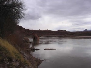
It was a sandy and mellow trip until just before the end when we went into some green brush and trees. It was a short section, but it touched our vehicles in spots. We popped out on the other side right next to the water. There was plenty of room for us to park in a circle.

We all got out to stand next to the water and take in the gorgeous scenery. A large group of rafters had camped across the water and it looked like they were getting ready to start their day. It was a nice setup.

We hung out on the picnic tables in shade for a little bit, but we knew we had a long day ahead of us on White Rim so we didn't stay too long. Walt broke out the peppers so we snacked for a bit, and then we headed back out.

The ascent back up to White Rim wasn't long but it was a good time. We got off the trail and agreed that it was well worth the trip. Even if we were only doing Shafer Trail and not all of White Rim, it would be a good side trip to come down to Lathrop Canyon in the future.

blue_sky
boat_launch
bottom_of_the_hill
brush_near_the_end
buttes
colorado_river_part_1
colorado_river_part_2
colorado_river_part_3
colorado_river_part_4
colors
curved
descent_part_1
descent_part_2
descent_part_3
descent_part_4
desert_view
easy_trail
eroded
group_shot
hanging_out
julie_at_the_river
jumble
les_and_ben
les_at_the_river
matt_at_the_end
matt_on_the_way_in
monica_and_matt
monica_at_the_end
overhang
parked_at_the_end
picnic_tables_part_1
picnic_tables_part_2
puddle
reds
scenery
shade
sitting_in_the_shade
slickrock_patch
start_of_the_trail
straight_portion
stripes
tippy_rock
trailhead_sign
tree_in_the_middle
up_and_around
wash
white_layer

Report from a Different Day

March 28, 2006

Led by Ladd G.
Lathrop Canyon is an optional side trail off of White Rim. We planned on hitting as many of the trails as possible in the Canyonlands National Park, and Lathrop Canyon was a good one to take to view the Colorado River. We planned to have lunch at the trail end….
Join Us!
If you aren’t a Member or Subscriber, you can’t see all of the content on this site. Get membership information to see why this site is best when you join and log in

Information for Subscribers

When you log in you’ll see more information here:

  • Recent Community Forum posts
  • Recent polls
  • Upcoming Events you can attend
  • Links to online users

© 2000-2022 · TrailDamage.com · Terms and Conditions · About · Contact
Trail information is only accurate on the date posted. Trails may have changed or closed since that date. Use this information for historical purposes only.
Contact the Forest Service or Bureau of Land Management for up-to-date trail information.

/* ----------------------------------------- */ /* View slug: reports-other-reports-for-same-trail-slider - start */ /* ----------------------------------------- */ /* place the prev/next controls on the sides */ .td-transition-controls .wpv-filter-next-link, .td-transition-controls .wpv-filter-previous-link { border: none; font-size: 300%; position: absolute; top: 70px; } .td-transition-controls .wpv-filter-previous-link { left: 0; } .td-transition-controls .wpv-filter-next-link { right: 0; } /* center the page selector horizonatally */ .td-transition-controls ul.wpv_pagination_dots { text-align: center; margin-top: 10px; } /* center the page selector horizonatally */ .td-transition-controls ul.wpv_pagination_dots li.wpv_pagination_dots_item, .td-transition-controls .wpv_pagination_dots li a { display: inline-block; float: none; } /* remove the default styles */ .td-transition-controls .wpv_pagination_dots li a { text-decoration: none; border-bottom: none; } .td-slider-container { padding: 0 25px; margin-bottom: 20px; position: relative; width:100%; display:table; } .td-slides { position: relative; } .td-slides-image { float:left; display:table-cell; } .td-slides-image img { border:1px solid #c0c0c0; } .td-slides-content { padding:4px 4px 4px 10px; border-top:1px solid #c0c0c0; border-right:1px solid #c0c0c0; border-bottom:1px solid #c0c0c0; display:table-cell; height:227px; overflow:hidden; } .td-slides-content h3 { margin-top:8px; } .td-slides-leader { font-size:smaller; margin-top:4px; } /* ----------------------------------------- */ /* View slug: reports-other-reports-for-same-trail-slider - end */ /* ----------------------------------------- */
/* ----------------------------------------- */ /* Content Template: Template for a Single Report - start */ /* ----------------------------------------- */ .entry-header { display:none; } .entry-content h1 { margin-top:16px; padding-top:0; } h1 a { color:#222; } h1 a:hover { color:#666; } p.entry-meta { font-size:small; } #report-body-spacer { clear:both; width:100%; height:20px; } #addtoany-bar { margin-bottom:2em; text-align:center; } .category-reports .post-info .author, .post-info .date { display: none; } .addthis_recommended_horizontal { text-align:center !important; } /* ----------------------------------------- */ /* Content Template: Template for a Single Report - end */ /* ----------------------------------------- */ /* ----------------------------------------- */ /* Content Template: Loop item in REPORTS Runners - start */ /* ----------------------------------------- */ #runners-container { width:100%; clear:both; } .runner { border:1px solid #c0c0c0; margin:0 6px 6px 0; float:left; width:49%; height:81px; } .runner-image { float: left; } .runner-image img { margin:2px 10px 0 2px; height:75px; width:75px; } .runner-name { text-transform:uppercase; } .runner-name a { color:#222; } .runner-name a:hover { color:#666; } .runner-vehicle { font-size:small; } @media only screen and (max-width: 768px) { .runner { width:100%; } } /* ----------------------------------------- */ /* Content Template: Loop item in REPORTS Runners - end */ /* ----------------------------------------- */