TrailDamage.com

Photos, videos and information about 4x4 trails in Colorado and Utah

  • Trails
    • Colorado
    • Utah
  • Reports
    • Featured Photos
    • Featured Videos
    • Reports Calendar
  • Members
  • Search
  • Trail Damage Winners
  • FAQ
  • Community
  • Upcoming Events
  • Membership
  • Log In
  • Facebook
  • Instagram
  • RSS
  • Twitter
  • YouTube

Imogene Pass 170908

September 8, 2017 by Monica

Imogene Pass

Trail Run on September 8, 2017
Report and photos by Monica I., Trail Leader
View trail information for Imogene Pass

Niko K.
Gray 2017 Jeep Wrangler Unlimited
Monica I.
Red 2010 Jeep Wrangler Rubicon
Walt S.
Gray 2018 Jeep Wrangler Unlimited Rubicon

We had a blast on Black Bear Pass and a really nice lunch in Telluride at a park, and we made it across town to start Imogene Pass.  We immediately saw signs noting the road was closed, but then found out from someone coming the other way that the trail would be closed for the Imogene Pass Run the next day.  We got lucky, because we didn't know about it beforehand.  It would have been a bummer to make it over to Telluride and then not be able to take a 4x4 road back to Ouray.  We saw more signs and cones along the way, but the road was open for us.

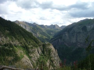
The climb out of town was nice, though we passed quite a few vehicles coming in the other direction.  Skies were hazy from fires in the western half of the country, but we could still see the switchbacks on Black Bear Pass and Bridal Veil Falls in the distance as we climbed.  It's a pretty cool sight.

Aspen leaves were still green, and the weather was perfect.  It didn't take us too long to get to the Smuggler Union Mine where we spent quite a bit of time.  There are lots of photos to take, a mine shaft to look down, and mining equipment and remnants all over the place.  We liked it more than the Tomboy townsite, but that might be because there were lots of people at Tomboy just up the trail.  Though we got out at Tomboy, we didn't spend much time there at all.  It was just too crowded.

The trail was surprisingly difficult just south of Tomboy where there were quite a few options and none of them easy.  The climbs were steep and twisty, but usually pretty short.  It was pretty fun.

We worked our way up to the high elevations of Imogene Pass where we didn't stop, though we did go over to the overlook.  There were a few other people up there, but it's a big area so there was plenty of room.  It was really, really windy, so we took our pictures and moved on.

The trail on the way down from the pass is nice, and not too difficult.  When we got to the network of trails next to the Hidden Treasure Mine and Upper Camp Bird, we went off to play.  There are lots of little hills, narrow sections, and a closed mine that had its gate nearly ripped off.  We got flashlights to peer down the tunnel, but didn't go in.  Closed mines are way too dangerous, and it's private property.  We drove around a bit more, and it was a fun diversion from the main trail.

The waterfall was next, and we wanted to explore a bit more.  We went down to the campsite and then up to the other side, but the waterfall wasn't as nice on that half.  It looked like the trail used to go through the water to the other side along an old dam that was fascinating to look at, but that option was gone now.  We cruised around to the other side to enjoy the water, and hung out for a bit before moving on.

We stayed on County Road 26A at the intersection, and that took us out to the crossing through Sneffels Creek.  It wasn't deep, but it was still fun.  Then the trail ended on County Road 26.

We talked about turning left to go see Yankee Boy Basin, but it had been a long day.  We decided that a campfire sounded better, so we turned right and headed back to Ouray.  It was an amazing day.

DSC01798
DSC01799
DSC01800
DSC01801
DSC01802
DSC01804
DSC01806
DSC01807
DSC01808
DSC01809
DSC01810
DSC01811
DSC01812
DSC01813
DSC01814
DSC01817
DSC01819
DSC01820
DSC01824
DSC01825
DSC01826
DSC01827
DSC01828
DSC01829
DSC01831
DSC01832
DSC01833
DSC01834
DSC01836
DSC01837
DSC01838
DSC01840
DSC01842
DSC01843
DSC01844
DSC01845
DSC01846
DSC01847
DSC01848
DSC01849
DSC01851
DSC01853
DSC01854
DSC01856
DSC01857
DSC01858
DSC01860
DSC01861
DSC01862
DSC01863
DSC01864
DSC01865
DSC01866
DSC01868
DSC01869
DSC01870
DSC01871
DSC01872
DSC01874
DSC01876
DSC01877
DSC01878
DSC01879
DSC01880
DSC01881
DSC01883
DSC01886
DSC01887
DSC01889
DSC01890
DSC01891
DSC01892
DSC01894
DSC01896
DSC01897
DSC01898
DSC01900
DSC01902
DSC01904
DSC01906
DSC01907
DSC01908
DSC01909
DSC01911
DSC01912
DSC01913
DSC01914
DSC01915
DSC01916
DSC01917
DSC01918
DSC01919
DSC01920
DSC01921
DSC01922
DSC01923
DSC01924
DSC01925
DSC01926
DSC01927
DSC01928
DSC01929
DSC01930
DSC01931
DSC01932
DSC01933
DSC01934
DSC01935
DSC01936
DSC01937
DSC01938
DSC01939
DSC01940
DSC01941
DSC01942
DSC01944
DSC01945
DSC01947
DSC01949
DSC01950
DSC01952
DSC01953
DSC01955
DSC01956
DSC01957
DSC01959
DSC01961
DSC01962
DSC01963
DSC01965
DSC01966
DSC01967
DSC01968
DSC01969
DSC01971
DSC01973
DSC01974
DSC01975
DSC01976
DSC01977
DSC01978
DSC01979
DSC01984
DSC01986
DSC01987
DSC01989
DSC01990
DSC01991
DSC01992
DSC01993
DSC01994
DSC01995
DSC01997
DSC01998
DSC01999
DSC02002
DSC02003
DSC02005
DSC02007
DSC02009
DSC02010
DSC02011
DSC02012
DSC02013
DSC02014
DSC02015
DSC02016
DSC02017
DSC02018
DSC02019
DSC02020
DSC02021
DSC02022
DSC02024
DSC02025
DSC02026
DSC02027
DSC02028
DSC02029
DSC02030

Reports from Other Days: 4

Use the arrows or dots to flip through the previews of the other reports for Imogene Pass. Click one of them to read more and see all of the photos from that day.

August 29, 2008

Led by Monica I.
You can’t do Black Bear Pass without completing the loop with Imogene Pass, and that’s exactly what we did. It was easy to find the trailhead with a GPS, which was a nice change from the last time when we didn’t have auto-routing. We even enjoyed our drive through Telluride,…
« »
  • 1
  • 2
  • 3
  • 4
Join Us!
If you aren’t a Member or Subscriber, you can’t see all of the content on this site. Get membership information to see why this site is best when you join and log in

Information for Subscribers

When you log in you’ll see more information here:

  • Recent Community Forum posts
  • Recent polls
  • Upcoming Events you can attend
  • Links to online users

© 2000-2021 · TrailDamage.com · Terms and Conditions · About · Contact
Trail information is only accurate on the date posted. Trails may have changed or closed since that date. Use this information for historical purposes only.
Contact the Forest Service or Bureau of Land Management for up-to-date trail information.

/* ----------------------------------------- */ /* View slug: reports-other-reports-for-same-trail-slider - start */ /* ----------------------------------------- */ /* place the prev/next controls on the sides */ .td-transition-controls .wpv-filter-next-link, .td-transition-controls .wpv-filter-previous-link { border: none; font-size: 300%; position: absolute; top: 70px; } .td-transition-controls .wpv-filter-previous-link { left: 0; } .td-transition-controls .wpv-filter-next-link { right: 0; } /* center the page selector horizonatally */ .td-transition-controls ul.wpv_pagination_dots { text-align: center; margin-top: 10px; } /* center the page selector horizonatally */ .td-transition-controls ul.wpv_pagination_dots li.wpv_pagination_dots_item, .td-transition-controls .wpv_pagination_dots li a { display: inline-block; float: none; } /* remove the default styles */ .td-transition-controls .wpv_pagination_dots li a { text-decoration: none; border-bottom: none; } .td-slider-container { padding: 0 25px; margin-bottom: 20px; position: relative; width:100%; display:table; } .td-slides { position: relative; } .td-slides-image { float:left; display:table-cell; } .td-slides-image img { border:1px solid #c0c0c0; } .td-slides-content { padding:4px 4px 4px 10px; border-top:1px solid #c0c0c0; border-right:1px solid #c0c0c0; border-bottom:1px solid #c0c0c0; display:table-cell; height:227px; overflow:hidden; } .td-slides-content h3 { margin-top:8px; } .td-slides-leader { font-size:smaller; margin-top:4px; } /* ----------------------------------------- */ /* View slug: reports-other-reports-for-same-trail-slider - end */ /* ----------------------------------------- */
/* ----------------------------------------- */ /* Content Template: Template for a Single Report - start */ /* ----------------------------------------- */ .entry-header { display:none; } .entry-content h1 { margin-top:16px; padding-top:0; } h1 a { color:#222; } h1 a:hover { color:#666; } p.entry-meta { font-size:small; } #report-body-spacer { clear:both; width:100%; height:20px; } #addtoany-bar { margin-bottom:2em; text-align:center; } .category-reports .post-info .author, .post-info .date { display: none; } .addthis_recommended_horizontal { text-align:center !important; } /* ----------------------------------------- */ /* Content Template: Template for a Single Report - end */ /* ----------------------------------------- */ /* ----------------------------------------- */ /* Content Template: Loop item in REPORTS Runners - start */ /* ----------------------------------------- */ #runners-container { width:100%; clear:both; } .runner { border:1px solid #c0c0c0; margin:0 6px 6px 0; float:left; width:49%; height:81px; } .runner-image { float: left; } .runner-image img { margin:2px 10px 0 2px; height:75px; width:75px; } .runner-name { text-transform:uppercase; } .runner-name a { color:#222; } .runner-name a:hover { color:#666; } .runner-vehicle { font-size:small; } @media only screen and (max-width: 768px) { .runner { width:100%; } } /* ----------------------------------------- */ /* Content Template: Loop item in REPORTS Runners - end */ /* ----------------------------------------- */