TrailDamage.com

Photos, videos and information about 4x4 trails in Colorado and Utah

  • Trails
    • Colorado
    • Utah
  • Reports
    • Featured Photos
    • Featured Videos
    • Reports Calendar
  • Members
  • Search
  • Trail Damage Winners
  • FAQ
  • Community
  • Upcoming Events
  • Membership
  • Log In
  • Facebook
  • Instagram
  • RSS
  • Twitter
  • YouTube

Hole In The Rock Trail 130523

May 23, 2013 by Monica

Hole In The Rock Trail

Trail Run on May 23, 2013
Report and photos by Monica I., Trail Leader
View trail information for Hole In The Rock Trail

Mike S.
Silver 2004 Jeep Wrangler Rubicon
Bill S.
Khaki 2004 Jeep Wrangler Rubicon
Walt S.
Gold 2004 Jeep Wrangler Rubicon
Jeffrey M.
Khaki 2006 Jeep Wrangler Unlimited Rubicon
Roger R.
White 2005 Jeep Wrangler Unlimited Rubicon
Ladd G.
Green 2003 Jeep Wrangler Rubicon
Monica I.
Red 2010 Jeep Wrangler Rubicon

We planned on driving from Denver to camp that night on the Hole In The Rock trail, but I-70 was closed in Glenwood Canyon and it threw a wrench into our plans. It put us a few hours behind, so we found the trailhead just before lunch. We all got gas in Blanding and we all had extra gas with us. We'd end up needing it.

The beginning of the trail is easy and we stopped for lunch at the first tree we could find. It was a hot day already and the shade was nice. It was also really, really windy so we ate a lot of sand. Utah has been "putting the crunch in your lunch" for ages and it was on a roll. We didn't hang out for long, as we were eager to get started.

Our original plan was to explore Lake Canyon as well as Hole In The Rock, but we didn't have time. We would skip Lake Canyon as well as the end of Nokai Dome, but we had plans to come back some other time to check them out. Other than a quick stop at the old truck marking the connector to Lake Canyon, we cruised through the easy part of the trail to the Nokai Dome spur.

Ladd had been on Hole In The Rock before, but he did it before the washout in 2009. That meant that a lot of the trail was new to him, too. When we turned to do the new connection between the old and new trails it definitely got more fun.

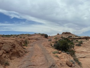
There were a few ledges and slickrock sections here and there, but it didn't really get fun until Twister. We all got out to enjoy watching the others come down the obstacle. After Twister came a lot of domes and fins of slickrock that were a lot of fun. We got to the sign pointing the way to the other side of the washout but we had to skip that, too. We were running low on time.

After that sign we were on the old trail, the one Ladd had done before. It suddenly became one of those trails we call "Shake and Bake" because you can't go very fast as you're thrown from side to side, over and over. It was hot, and it shook us for a while.

We found the sign for Grey Mesa and more fun started. We even found a woman in a very clean Xterra hanging out in the wash. There was a ledge there that would definitely be fun getting back up later.

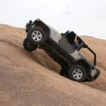
We stopped at the bottom of the Dugway to assess the situation. We couldn't tell at first glance that it was actually a long and challenging obstacle. You popped up the beginning part, steep but manageable. Then you cut over to the other side and started climbing. It was definitely an andrenaline rush.

Monica was first up the Dugway and she was feeling good until she got on a bad line near the edge of the shelf road, got tippy, and needed a spot back down. It was a bit of a scare. Jeffrey spotted her down and then offered to drive her Jeep through that part. Monica happily accepted and then everyone got a spot through that section, thankfully.

When we were all above that obnoxious section we found ourselves at the Dugway Camp, a wide and flat part of the Dugway that was sheltered on three sides by steep fins of slickrock. It was dinnertime and the camping looked good, so we stopped there for the night. It ended up being the best camping spot on the whole trail, and we enjoyed it.

The next morning, Monica decided to relax and wait for the others to run to the end and back. We figured that would take three hours or so. Like everything else, we underestimated the time and it was mid-afternoon before the group was reunited.

The rest of the trail was a blast. The Dugway continued with more of the slickrock hill, and we thought it was a fun way to start the day. We found some more slickrock sections after the Dugway, too. Once we were at the top of the Dugway we were on Grey Mesa and the trail was nice and smooth in most parts.

The Great Bend was probably the most scenic section of the trail. You could see the river twist around in the canyons and we had a great view of it all. We stopped there to relax for a bit and take lots of pictures.

The mesa was pretty easy to get across, and the trail was usually easy to find. We were heading down off of the mesa when we came to The Chute, a steep drop-off on slickrock. We couldn't believe they brought horses and wagons through here. We were all careful and spotted each other through it, and all went well.

We could see Lake Powell in the distance every once in a while, and when we got to the end of the 4x4 section we could even see the actual Hole In The Rock across the water. It looked pretty crazy. We decided not to do the hike to the end this time. We'd have to come back and do it another time.

It had taken us four hours to get from the Dugway Camp to the end of the trail. Miraculously, it only took us two hours to get back. The fact that we knew the trail really helped, and we didn't get lost or need to get out to find our way. We took a quick break with Monica at camp, but then we headed back down the Dugway.

The trail is just as much fun on the way out -- maybe even more fun. The "Shake and Bake" section wasn't any fun, still, but at least we knew it wouldn't last forever. It didn't seem to take us long at all to get out.

We even saw some other vehicles on their way in when we were almost out to the trailhead. Otherwise, the trail was deserted. It was a really great time, and we looked forward to doing more exploring the next time.

We ended up finishing at dinnertime again, and we headed into Halls Crossing for gas. We talked about trying to find another campsite nearby, but in the end a shower just sounded too good. We paid the fee to stay in the Lake Powell campground at Halls Crossing, and it was a welcome rest. It was clean, and the showers were glorious.

Ladd left for home early in the morning, and the rest of us got up ready to go. The trip hadn't gone exactly to plan, and the ferry was broken. It wouldn't be running, so we needed to drive around the lake the long way. A little pavement would be nice, anyway.

after_twister
airing_down
alcove
alternate_trailhead
antenna
big_view
bill_down_a_ledge
bill_down_the_chute_part_1
bill_down_the_chute_part_2
bill_down_the_chute_part_3
bill_down_the_chute_part_4
bill_down_the_chute_part_5
bill_in_twister_part_1
bill_in_twister_part_2
bill_in_twister_part_3
bill_on_slickrock
bill_on_the_trail
bill_starting_day_2
bill_tippy
bill_up_the_dugway
blue_sky_above_red
bones
bumpy
cactus_bloom
cairn_lizard
canyon
carsonite_sign
curve_in_rock
desert_scene
desert_weirdness
down_a_dome
driftwood
dugway_campsite_part_1
dugway_campsite_part_2
dugway_part_1
dugway_part_2
dugway_part_3
dugway_part_4
dugway_part_5
dugway_part_6
early_campsite
early_obstacle
early_trail
easy_curve
easy_trail
end_of_the_road
great_bend_part_1
great_bend_part_2
great_bend_part_3
great_bend_part_4
green_in_sand
grey_mesa_sign
hole_in_the_rock
into_the_hills
jeeps_at_lunch_part_1
jeeps_at_lunch_part_2
jeeps_at_lunch_part_3
jeeps
jeffrey_and_bill
jeffrey_down_a_ledge
jeffrey_down_the_chute_part_1
jeffrey_down_the_chute_part_2
jeffrey_down_the_chute_part_3
jeffrey_in_twister_part_1
jeffrey_in_twister_part_2
jeffrey_in_twister_part_3
jeffrey_on_slickrock
jeffrey_on_the_trail
jeffrey_starting_day_2
ladd_down_a_ledge
ladd_down_the_chute_part_1
ladd_down_the_chute_part_2
ladd_down_the_chute_part_3
ladd_in_twister_part_1
ladd_in_twister_part_2
ladd_in_twister_part_3
ladd_on_slickrock
ladd_on_the_trail
ladd_starting_day_2
ladd_up_the_dugway_part_1
ladd_up_the_dugway_part_2
ladd_up_the_dugway_part_3
lake_canyon_connector_intersection
lake_canyon_sign_at_south_end
layers
mike_and_roger
mike_down_a_ledge
mike_down_the_chute_part_1
mike_down_the_chute_part_2
mike_down_the_chute_part_3
mike_down_the_chute_part_4
mike_down_the_chute_part_5
mike_down_the_chute_part_6
mike_in_twister_part_1
mike_in_twister_part_2
mike_in_twister_part_3
mike_in_twister_part_4
mike_on_slickrock
mike_starting_day_2
mike_twisty
mike_up_the_dugway_part_1
mike_up_the_dugway_part_2
mike_up_the_dugway_part_3
mike_up_the_dugway_part_4
monica_after_twister
monica_in_twister_part_1
monica_in_twister_part_2
monica_on_the_trail
monica_up_the_dugway_part_1
monica_up_the_dugway_part_2
monica_up_the_dugway_part_3
monica_up_the_dugway_part_4
morning_climb
muddled_sky
nearly_blooming
nokai_dome
old_truck
painted_lines_and_rubber
parked_at_the_great_bend
purple_flowers
roger_and_mike
roger_down_a_ledge
roger_down_slickrock
roger_down_the_chute_part_1
roger_down_the_chute_part_2
roger_down_the_chute_part_3
roger_down_the_chute_part_4
roger_in_twister_part_1
roger_in_twister_part_2
roger_in_twister_part_3
roger_in_twister_part_4
roger_on_slickrock
roger_on_the_trail
roger_starting_day_2
roger_up_the_dugway_part_1
roger_up_the_dugway_part_2
sandy
scenery
slickrock_and_sand
slickrock_bumps
slickrock_trail
snoopy
straight_but_slow
sunset
tall_plant
the_chute
track_along_slickrock
trail_sign
trailhead_sign_1
trailhead_sign_2
trailhead_sign_3
twister
up_the_chute
up_the_dugway
view_from_the_dugway_campsite
walt_down_a_ledge
walt_down_the_chute_part_1
walt_down_the_chute_part_2
walt_down_the_chute_part_3
walt_down_the_chute_part_4
walt_down_the_chute_part_5
walt_in_twister_part_1
walt_in_twister_part_2
walt_in_twister_part_3
walt_on_slickrock
walt_on_the_trail
walt_starting_day_2
walt_up_the_dugway_part_1
walt_up_the_dugway_part_2
walt_up_the_dugway_part_3
walt_up_the_dugway_part_4

Report from a Different Day

May 7, 2005

Led by Ladd G.
We left Moab on May 7th at about 3:00PM and headed south to Blanding, about 73 miles away. You should stop for gas in Moab because the next gas station is at Halls Crossing, 83 miles from Blanding. We didn’t and though we made it we came off the trail…
Join Us!
If you aren’t a Member or Subscriber, you can’t see all of the content on this site. Get membership information to see why this site is best when you join and log in

Information for Subscribers

When you log in you’ll see more information here:

  • Recent Community Forum posts
  • Recent polls
  • Upcoming Events you can attend
  • Links to online users

© 2000-2019 · TrailDamage.com · Terms and Conditions · About · Contact
Trail information is only accurate on the date posted. Trails may have changed or closed since that date. Use this information for historical purposes only.
Contact the Forest Service or Bureau of Land Management for up-to-date trail information.

/* ----------------------------------------- */ /* View slug: reports-other-reports-for-same-trail-slider - start */ /* ----------------------------------------- */ /* place the prev/next controls on the sides */ .td-transition-controls .wpv-filter-next-link, .td-transition-controls .wpv-filter-previous-link { border: none; font-size: 300%; position: absolute; top: 70px; } .td-transition-controls .wpv-filter-previous-link { left: 0; } .td-transition-controls .wpv-filter-next-link { right: 0; } /* center the page selector horizonatally */ .td-transition-controls ul.wpv_pagination_dots { text-align: center; margin-top: 10px; } /* center the page selector horizonatally */ .td-transition-controls ul.wpv_pagination_dots li.wpv_pagination_dots_item, .td-transition-controls .wpv_pagination_dots li a { display: inline-block; float: none; } /* remove the default styles */ .td-transition-controls .wpv_pagination_dots li a { text-decoration: none; border-bottom: none; } .td-slider-container { padding: 0 25px; margin-bottom: 20px; position: relative; width:100%; display:table; } .td-slides { position: relative; } .td-slides-image { float:left; display:table-cell; } .td-slides-image img { border:1px solid #c0c0c0; } .td-slides-content { padding:4px 4px 4px 10px; border-top:1px solid #c0c0c0; border-right:1px solid #c0c0c0; border-bottom:1px solid #c0c0c0; display:table-cell; height:227px; overflow:hidden; } .td-slides-content h3 { margin-top:8px; } .td-slides-leader { font-size:smaller; margin-top:4px; } /* ----------------------------------------- */ /* View slug: reports-other-reports-for-same-trail-slider - end */ /* ----------------------------------------- */
/* ----------------------------------------- */ /* Content Template: Template for a Single Report - start */ /* ----------------------------------------- */ .entry-header { display:none; } .entry-content h1 { margin-top:16px; padding-top:0; } h1 a { color:#222; } h1 a:hover { color:#666; } p.entry-meta { font-size:small; } #report-body-spacer { clear:both; width:100%; height:20px; } #addtoany-bar { margin-bottom:2em; text-align:center; } .category-reports .post-info .author, .post-info .date { display: none; } .addthis_recommended_horizontal { text-align:center !important; } /* ----------------------------------------- */ /* Content Template: Template for a Single Report - end */ /* ----------------------------------------- */ /* ----------------------------------------- */ /* Content Template: Loop item in REPORTS Runners - start */ /* ----------------------------------------- */ #runners-container { width:100%; clear:both; } .runner { border:1px solid #c0c0c0; margin:0 6px 6px 0; float:left; width:49%; height:81px; } .runner-image { float: left; } .runner-image img { margin:2px 10px 0 2px; height:75px; width:75px; } .runner-name { text-transform:uppercase; } .runner-name a { color:#222; } .runner-name a:hover { color:#666; } .runner-vehicle { font-size:small; } @media only screen and (max-width: 768px) { .runner { width:100%; } } /* ----------------------------------------- */ /* Content Template: Loop item in REPORTS Runners - end */ /* ----------------------------------------- */