TrailDamage.com

Photos, videos and information about 4x4 trails in Colorado and Utah

  • Trails
    • Colorado
    • Utah
  • Reports
    • Featured Photos
    • Featured Videos
    • Reports Calendar
  • Members
  • Search
  • Trail Damage Winners
  • FAQ
  • Community
  • Upcoming Events
  • Membership
  • Log In
  • Facebook
  • Instagram
  • RSS
  • Twitter
  • YouTube

Guanella Pass 050130

January 30, 2005 by Bob S.

Guanella Pass

Trail Run on January 30, 2005
Report and photos by Bob S., Trail Leader
View trail information for Guanella Pass

Bob S.
Green 1997 Jeep Wrangler

After finishing the Georgetown Ice Races, Bob decided to take the "scenic" route home and took Guanella Pass across to Highway 285 to go home. He wasn't sure how much snow would be on the trail, but figured if it got too deep, he'd just turn around. Since he was doing the trail solo he wouldn't have any backup.

While Guanella pass is little more than a paved road during the summer, it is not maintained or plowed during the winter so can get very deep with snow. This time, the snow wasn't too deep, only 8 to 12 inches There were already tracks from other vehicles traversing it, so Bob knew he'd have no problems.

After passing the hydroelectric dam, the snow finally began getting deep but was still easily passable, with tracks still very visible. There was only about a foot of powdery snow on the road.

Not too far in, Bob came across a couple of Jeeps -- a Cherokee and Wrangler. The Cherokee was parked at the top of the hill, and the Wrangler off to the side, half way down the hill. Bob thought he'd stop and say hello, and see if they were all right. Sure enough, the Wrangler had been playing around, and had gone too far to the left edge of the snow and hung his front driver's side tire over a berm of snow, high-centering his front axle. Bob was happy to offer a tow, as their friends in the Cherokee didn't have a strap.

Bob turned around to head down hill and pull his TJ out, and sure enough stuck his passenger side tire on the same type of snow berm, but on the opposite side of the trail. After driving sideways at a 45 degree angle halfway down the hill, Bob finally managed to pop his tire free. It was obvious why it was so difficult for the other guy to get his Jeep free, and since the other Jeep had little or no lift, he couldn't straddle the berm until free. Everyone chuckled about this, and that it was lucky Bob hadn't stuck himself in the process. After pulling the stuck TJ out, Bob gathered his strap and wished the others good luck as they left. T
he grateful group thanked Bob and went on their way down toward Georgetown.

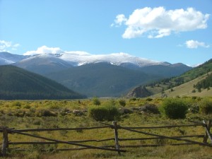
Much of the rest of the trail was uneventful. There were beautiful views and very deep snow in places, but still nothing that would stop Bob from continuing without difficulty. About 45 minutes after starting, Bob arrived at Highway 285, aired up and headed North back toward home.

big_trees
bob_and_towering_trees_part_1
bob_and_towering_trees_part_2
bob_at_the_top_of_the_pass_part_1
bob_at_the_top_of_the_pass_part_2
bob_in_deeper_snow_part_1
bob_in_deeper_snow_part_2
bob_in_deeper_snow_part_3
bob_in_deeper_snow_part_4
bob_in_deeper_snow_part_5
bob_in_deeper_snow_part_6
bob_making_fresh_tracks_part_1
bob_making_fresh_tracks_part_2
bob_on_the_trail_part_1
bob_on_the_trail_part_2
bob_on_the_trail_part_3
bob_on_the_trail_part_4
bob_on_the_trail_part_5
bob_on_the_trail_part_6
georgetown_and_the_frozen_lake
guanella_pass_trail
snowplow
snowy_georgetown
top_of_guanella_pass_part_1
top_of_guanella_pass_part_2
top_of_guanella_pass_part_3
towering_trees

Reports from Other Days: 3

Use the arrows or dots to flip through the previews of the other reports for Guanella Pass. Click one of them to read more and see all of the photos from that day.

September 13, 2008

Led by Monica I.
Guanella Pass used to be a fun little trail, but they have paved quite a bit of it. So this one is a "gimme" — an easy way to rack up your trail count. We were aired up already, which made the potholes even worse. It really isn’t a "trail"…
»
  • 1
  • 2
  • 3
Join Us!
If you aren’t a Member or Subscriber, you can’t see all of the content on this site. Get membership information to see why this site is best when you join and log in

Information for Subscribers

When you log in you’ll see more information here:

  • Recent Community Forum posts
  • Recent polls
  • Upcoming Events you can attend
  • Links to online users

© 2000-2022 · TrailDamage.com · Terms and Conditions · About · Contact
Trail information is only accurate on the date posted. Trails may have changed or closed since that date. Use this information for historical purposes only.
Contact the Forest Service or Bureau of Land Management for up-to-date trail information.

/* ----------------------------------------- */ /* View slug: reports-other-reports-for-same-trail-slider - start */ /* ----------------------------------------- */ /* place the prev/next controls on the sides */ .td-transition-controls .wpv-filter-next-link, .td-transition-controls .wpv-filter-previous-link { border: none; font-size: 300%; position: absolute; top: 70px; } .td-transition-controls .wpv-filter-previous-link { left: 0; } .td-transition-controls .wpv-filter-next-link { right: 0; } /* center the page selector horizonatally */ .td-transition-controls ul.wpv_pagination_dots { text-align: center; margin-top: 10px; } /* center the page selector horizonatally */ .td-transition-controls ul.wpv_pagination_dots li.wpv_pagination_dots_item, .td-transition-controls .wpv_pagination_dots li a { display: inline-block; float: none; } /* remove the default styles */ .td-transition-controls .wpv_pagination_dots li a { text-decoration: none; border-bottom: none; } .td-slider-container { padding: 0 25px; margin-bottom: 20px; position: relative; width:100%; display:table; } .td-slides { position: relative; } .td-slides-image { float:left; display:table-cell; } .td-slides-image img { border:1px solid #c0c0c0; } .td-slides-content { padding:4px 4px 4px 10px; border-top:1px solid #c0c0c0; border-right:1px solid #c0c0c0; border-bottom:1px solid #c0c0c0; display:table-cell; height:227px; overflow:hidden; } .td-slides-content h3 { margin-top:8px; } .td-slides-leader { font-size:smaller; margin-top:4px; } /* ----------------------------------------- */ /* View slug: reports-other-reports-for-same-trail-slider - end */ /* ----------------------------------------- */
/* ----------------------------------------- */ /* Content Template: Template for a Single Report - start */ /* ----------------------------------------- */ .entry-header { display:none; } .entry-content h1 { margin-top:16px; padding-top:0; } h1 a { color:#222; } h1 a:hover { color:#666; } p.entry-meta { font-size:small; } #report-body-spacer { clear:both; width:100%; height:20px; } #addtoany-bar { margin-bottom:2em; text-align:center; } .category-reports .post-info .author, .post-info .date { display: none; } .addthis_recommended_horizontal { text-align:center !important; } /* ----------------------------------------- */ /* Content Template: Template for a Single Report - end */ /* ----------------------------------------- */ /* ----------------------------------------- */ /* Content Template: Loop item in REPORTS Runners - start */ /* ----------------------------------------- */ #runners-container { width:100%; clear:both; } .runner { border:1px solid #c0c0c0; margin:0 6px 6px 0; float:left; width:49%; height:81px; } .runner-image { float: left; } .runner-image img { margin:2px 10px 0 2px; height:75px; width:75px; } .runner-name { text-transform:uppercase; } .runner-name a { color:#222; } .runner-name a:hover { color:#666; } .runner-vehicle { font-size:small; } @media only screen and (max-width: 768px) { .runner { width:100%; } } /* ----------------------------------------- */ /* Content Template: Loop item in REPORTS Runners - end */ /* ----------------------------------------- */