TrailDamage.com

Photos, videos and information about 4x4 trails in Colorado and Utah

  • Trails
    • Colorado
    • Utah
  • Reports
    • Featured Photos
    • Featured Videos
    • Reports Calendar
  • Members
  • Search
  • Trail Damage Winners
  • FAQ
  • Community
  • Upcoming Events
  • Membership
  • Log In
  • Facebook
  • Instagram
  • RSS
  • Twitter
  • YouTube

Grizzly Jeep Trail 070721

July 21, 2007 by Monica

Grizzly Jeep Trail

Trail Run on July 21, 2007
Report and photos by Monica I., Trail Leader
View trail information for Grizzly Jeep Trail

Mike S.
Silver 2004 Jeep Wrangler Rubicon
Don W.
Silver 2005 Jeep Wrangler Rubicon
Monica I.
Red 2010 Jeep Wrangler Rubicon
Bill S.
Khaki 2004 Jeep Wrangler Rubicon

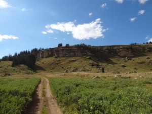
We had just come off of Coffee Pot Road and we had high hopes for Grizzly Jeep Trail. We had read that there were challenging rocks in the middle. The rocks weren't at all challenging, but the scenery was amazing, making this one of the best trails of the day.

The trail was muddy the entire way, and we all started to get our Jeeps covered. The puddles were plentiful, and you couldn't avoid them. They were right in the middle of the trail and covered it from edge to edge. There were some tracks from people making illegal bypasses, but naturally we didn't take any of them.

We saw some people camping at the top of the big ridge. They were on ATVs and they were happy to see such muddy Jeeps. They took pictures of all of us, and we were on our way.

It was cool going over the flat rock. It was like Moab, and it made us all miss the slickrock. Even that rock had puddles in the depressions.

The views were phenomenal. We were surrounded by wild flowers, and the green covering everything was absolutely gorgeous. We couldn't get over the fact that this beautiful area had a maintained trail running through it so we could see it. Wow!

The unnamed pond was pretty, and we stopped for pictures and to stretch our legs. We wanted to get to the Grizzly Cow Camp, though, so we headed back out.

We crossed the stream and parked at the camp, and soon it started raining. We put tops and windows on our Jeeps (though Bill didn't have enough to close his Jeep) and hurried to get under the porch of the Forest Service building. All four of us fit nicely under there, out of the rain.

It started raining again while we ate, and we enjoyed sitting there in a dry area, watching the rain and the scenery. It couldn't have been a better lunch. That's one of the best things about wheeling -- the fantastic lunch spots.

We checked out the waterfall, and it was very scenic. We didn't hike down to it, though, because we still had a lot of ground to cover. We packed up and headed back out.

It wasn't long before we were at the end of the trail at the White Owl Lake trail. We turned right to head back to Coffee Pot Road. Grizzly Jeep Trail ended up being one of the best trails of the weekend, simply because the views were so amazing. It was also one of the best lunches we've had.

big_view
bill_down_rocks
bill_on_the_trail
colorful
don_down_rocks_part_1
don_down_rocks_part_2
don_on_the_trail
drive_across_rock
early_trail
green_and_blue
grizzly_cow_camp_in_the_distance
grizzly_cow_camp_part_1
grizzly_cow_camp_part_2
grizzly_cow_camp_part_3
grizzly_cow_camp_part_4
grizzly_cow_camp_part_5
jeeps
mike_on_the_trail
monica_on_the_trail
mud_puddle
old_burned_trees
puddle_crossing
ridge_of_rock
rocks_and_flowers
soft_green
soggy_trail
trail_stretching_ahead
trail_to_water
trail_with_campsite_on_the_left
trailhead_sign
trailhead
water
wild_flowers

Report from a Different Day

August 14, 2015

Led by Monica I.
The Flat Tops trails are often little more than bumpy roads, but Grizzly Jeep Trail offers a bit more fun. We were looking forward to it, so we finished White Owl Lake and started Grizzly Jeep Trail on the western end. The warning signs about high clearance and four-wheel drive…
Join Us!
If you aren’t a Member or Subscriber, you can’t see all of the content on this site. Get membership information to see why this site is best when you join and log in

Information for Subscribers

When you log in you’ll see more information here:

  • Recent Community Forum posts
  • Recent polls
  • Upcoming Events you can attend
  • Links to online users

© 2000-2021 · TrailDamage.com · Terms and Conditions · About · Contact
Trail information is only accurate on the date posted. Trails may have changed or closed since that date. Use this information for historical purposes only.
Contact the Forest Service or Bureau of Land Management for up-to-date trail information.

/* ----------------------------------------- */ /* View slug: reports-other-reports-for-same-trail-slider - start */ /* ----------------------------------------- */ /* place the prev/next controls on the sides */ .td-transition-controls .wpv-filter-next-link, .td-transition-controls .wpv-filter-previous-link { border: none; font-size: 300%; position: absolute; top: 70px; } .td-transition-controls .wpv-filter-previous-link { left: 0; } .td-transition-controls .wpv-filter-next-link { right: 0; } /* center the page selector horizonatally */ .td-transition-controls ul.wpv_pagination_dots { text-align: center; margin-top: 10px; } /* center the page selector horizonatally */ .td-transition-controls ul.wpv_pagination_dots li.wpv_pagination_dots_item, .td-transition-controls .wpv_pagination_dots li a { display: inline-block; float: none; } /* remove the default styles */ .td-transition-controls .wpv_pagination_dots li a { text-decoration: none; border-bottom: none; } .td-slider-container { padding: 0 25px; margin-bottom: 20px; position: relative; width:100%; display:table; } .td-slides { position: relative; } .td-slides-image { float:left; display:table-cell; } .td-slides-image img { border:1px solid #c0c0c0; } .td-slides-content { padding:4px 4px 4px 10px; border-top:1px solid #c0c0c0; border-right:1px solid #c0c0c0; border-bottom:1px solid #c0c0c0; display:table-cell; height:227px; overflow:hidden; } .td-slides-content h3 { margin-top:8px; } .td-slides-leader { font-size:smaller; margin-top:4px; } /* ----------------------------------------- */ /* View slug: reports-other-reports-for-same-trail-slider - end */ /* ----------------------------------------- */
/* ----------------------------------------- */ /* Content Template: Template for a Single Report - start */ /* ----------------------------------------- */ .entry-header { display:none; } .entry-content h1 { margin-top:16px; padding-top:0; } h1 a { color:#222; } h1 a:hover { color:#666; } p.entry-meta { font-size:small; } #report-body-spacer { clear:both; width:100%; height:20px; } #addtoany-bar { margin-bottom:2em; text-align:center; } .category-reports .post-info .author, .post-info .date { display: none; } .addthis_recommended_horizontal { text-align:center !important; } /* ----------------------------------------- */ /* Content Template: Template for a Single Report - end */ /* ----------------------------------------- */ /* ----------------------------------------- */ /* Content Template: Loop item in REPORTS Runners - start */ /* ----------------------------------------- */ #runners-container { width:100%; clear:both; } .runner { border:1px solid #c0c0c0; margin:0 6px 6px 0; float:left; width:49%; height:81px; } .runner-image { float: left; } .runner-image img { margin:2px 10px 0 2px; height:75px; width:75px; } .runner-name { text-transform:uppercase; } .runner-name a { color:#222; } .runner-name a:hover { color:#666; } .runner-vehicle { font-size:small; } @media only screen and (max-width: 768px) { .runner { width:100%; } } /* ----------------------------------------- */ /* Content Template: Loop item in REPORTS Runners - end */ /* ----------------------------------------- */