TrailDamage.com

Photos, videos and information about 4x4 trails in Colorado and Utah

  • Trails
    • Colorado
    • Utah
  • Reports
    • Featured Photos
    • Featured Videos
    • Reports Calendar
  • Members
  • Search
  • Trail Damage Winners
  • FAQ
  • Community
  • Upcoming Events
  • Membership
  • Log In
  • Facebook
  • Instagram
  • RSS
  • Twitter
  • YouTube

Greer Road South 130720

July 20, 2013 by Monica

Greer Road South

Trail Run on July 20, 2013
Report and photos by Monica I., Trail Leader
View trail information for Greer Road South

Jerry V.
Orange 1987 Jeep Wrangler
Matt K.
White 2016 Jeep Wrangler Unlimited Rubicon
Julie M.
Green 2012 Jeep Wrangler Unlimited Rubicon
Roger R.
White 2005 Jeep Wrangler Unlimited Rubicon
Monica I.
Red 2010 Jeep Wrangler Rubicon

Plain and simple, Greer Road is a mess. It is forest service road 154 with a few fun spurs. But there is private property right in the middle of it that breaks it into three trails that don't connect to each other. We hoped that the southern two sections would connect because the distance between them on the Motor Vehicle Use Map is small enough to be a mistake, but it wasn't to be. The two trails are separated by about 550 feet of private property, making it a challenge to do the two halves of Greer Road South.

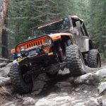
We did Ballard Road out to the western half first. After pulling a car out of a muddy ditch we ended up following Elk Creek along the rocks. What a fun surprise -- rocks! They started out fun enough, but the Rock Garden was the best. The climb was bumpy, and the mud and water was making things festive. We all enjoyed climbing up the fun stuff. It was great for Jerry who was testing out his new Jeep. It performed perfectly.

When we got to the top we stopped to enjoy the solitude and a bit of open space. Julie broke out an RC Jeep and had fun driving it around the RC-sized Rock Garden. It was a good time for snacks and checking out Jerry's new Jeep, so we hung out for a while.

The Rock Garden was almost as fun on the way down, and it gave us a chance to get some good pictures. Everyone got nice and flexy.

We worked our way almost back to Pennock Pass where we turned to do the eastern section of Greer Road South. Julie and Jerry left us at this point. The other section was completely different, with smooth parts and open meadows. It was looking promising until we got to a huge gate that was very fortified and padlocked. The trail continued on the other side, but we would not be heading that way. You could see that there was a fence along it on the other side, so people were allowed through at some point. What a bummer! We found it hard to believe that a private party could close 550 feet of a public and well-known trail, but it turns out the owners family once contained the mayor of Fort Collins so anything is possible.

We had our fingers crossed, thinking we might be able to cross through to the northern section of Greer Road, but in the end we ran out of time because the trails didn't connect. Monica and Roger drove by the northern trail but we had to skip it. We'll check it out another day. Next time, we'll just do the rocky climb to the top.

along_elk_creek
blue_sky
bumpy
carsonite
challenge
chunky
colorful_colorado
curve_of_rocks
distant_mountain
easier_bumps
eastern_half
eastern_ledges
eastern_trail_end
first_rocks
good_stuff
in_the_trees
intersection_with_ballard_road
jerry_has_a_new_jeep
jerry_in_the_rock_garden_part_1
jerry_in_the_rock_garden_part_2
jerry_in_the_rock_garden_part_3
jerry_in_the_rock_garden_part_4
julie_in_the_rock_garden_part_1
julie_in_the_rock_garden_part_2
julie_in_the_rock_garden_part_3
loose
matt_in_the_rock_garden_part_1
matt_in_the_rock_garden_part_2
matt_in_the_rock_garden_part_3
meadow
mellow
monica_in_the_rock_garden_part_1
monica_in_the_rock_garden_part_2
monica_on_the_trail
open_area
open_on_the_east_side
parked_at_the_top
rock_garden_best
roger_in_the_rock_garden_part_1
roger_in_the_rock_garden_part_2
roger_in_the_rock_garden_part_3
sky_in_spots
slick_rocks
slippery
smooth_near_the_top
steep
sunshine
timber_part_1
timber_part_2
wet_climb
wooden_sign
working_our_way_up
Join Us!
If you aren’t a Member or Subscriber, you can’t see all of the content on this site. Get membership information to see why this site is best when you join and log in

Information for Subscribers

When you log in you’ll see more information here:

  • Recent Community Forum posts
  • Recent polls
  • Upcoming Events you can attend
  • Links to online users

© 2000-2021 · TrailDamage.com · Terms and Conditions · About · Contact
Trail information is only accurate on the date posted. Trails may have changed or closed since that date. Use this information for historical purposes only.
Contact the Forest Service or Bureau of Land Management for up-to-date trail information.

/* ----------------------------------------- */ /* View slug: reports-other-reports-for-same-trail-slider - start */ /* ----------------------------------------- */ /* place the prev/next controls on the sides */ .td-transition-controls .wpv-filter-next-link, .td-transition-controls .wpv-filter-previous-link { border: none; font-size: 300%; position: absolute; top: 70px; } .td-transition-controls .wpv-filter-previous-link { left: 0; } .td-transition-controls .wpv-filter-next-link { right: 0; } /* center the page selector horizonatally */ .td-transition-controls ul.wpv_pagination_dots { text-align: center; margin-top: 10px; } /* center the page selector horizonatally */ .td-transition-controls ul.wpv_pagination_dots li.wpv_pagination_dots_item, .td-transition-controls .wpv_pagination_dots li a { display: inline-block; float: none; } /* remove the default styles */ .td-transition-controls .wpv_pagination_dots li a { text-decoration: none; border-bottom: none; } .td-slider-container { padding: 0 25px; margin-bottom: 20px; position: relative; width:100%; display:table; } .td-slides { position: relative; } .td-slides-image { float:left; display:table-cell; } .td-slides-image img { border:1px solid #c0c0c0; } .td-slides-content { padding:4px 4px 4px 10px; border-top:1px solid #c0c0c0; border-right:1px solid #c0c0c0; border-bottom:1px solid #c0c0c0; display:table-cell; height:227px; overflow:hidden; } .td-slides-content h3 { margin-top:8px; } .td-slides-leader { font-size:smaller; margin-top:4px; } /* ----------------------------------------- */ /* View slug: reports-other-reports-for-same-trail-slider - end */ /* ----------------------------------------- */
/* ----------------------------------------- */ /* Content Template: Template for a Single Report - start */ /* ----------------------------------------- */ .entry-header { display:none; } .entry-content h1 { margin-top:16px; padding-top:0; } h1 a { color:#222; } h1 a:hover { color:#666; } p.entry-meta { font-size:small; } #report-body-spacer { clear:both; width:100%; height:20px; } #addtoany-bar { margin-bottom:2em; text-align:center; } .category-reports .post-info .author, .post-info .date { display: none; } .addthis_recommended_horizontal { text-align:center !important; } /* ----------------------------------------- */ /* Content Template: Template for a Single Report - end */ /* ----------------------------------------- */ /* ----------------------------------------- */ /* Content Template: Loop item in REPORTS Runners - start */ /* ----------------------------------------- */ #runners-container { width:100%; clear:both; } .runner { border:1px solid #c0c0c0; margin:0 6px 6px 0; float:left; width:49%; height:81px; } .runner-image { float: left; } .runner-image img { margin:2px 10px 0 2px; height:75px; width:75px; } .runner-name { text-transform:uppercase; } .runner-name a { color:#222; } .runner-name a:hover { color:#666; } .runner-vehicle { font-size:small; } @media only screen and (max-width: 768px) { .runner { width:100%; } } /* ----------------------------------------- */ /* Content Template: Loop item in REPORTS Runners - end */ /* ----------------------------------------- */