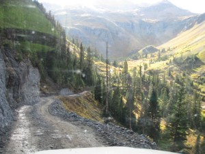
TrailDamage.com

Photos, videos and information about 4x4 trails in Colorado and Utah

  • Trails
    • Colorado
    • Utah
  • Reports
    • Featured Photos
    • Featured Videos
    • Reports Calendar
  • Members
  • Search
  • Trail Damage Winners
  • FAQ
  • Community
  • Upcoming Events
  • Membership
  • Log In
  • Facebook
  • Instagram
  • RSS
  • Twitter
  • YouTube

Governor Basin 040821

August 21, 2004 by Monica

Governor Basin

Trail Run on August 21, 2004
Report and photos by Monica I., Trail Leader
View trail information for Governor Basin

Jon G.
Khaki 2003 Jeep Wrangler
Ladd G.
Green 2003 Jeep Wrangler Rubicon
Monica I.
Red 2010 Jeep Wrangler Rubicon
Mike S.
Silver 2002 Jeep Wrangler

A few of us still wanted to do another trail after doing Black Bear Pass, Imogene Pass and Yankee Boy Basin so we continued on and did this trail. It was a fantastic surprise and probably the highlight of the trip.

It starts off on a climb that is already more challenging than Yankee Boy Basin. We came to a crossroads and arbitrarily decided to take the low road to the right. That brought us out to Governor Basin. When we got to the bottom of the basin we looked around and just picked a spur that went up to a big mine that turned out to be Mountain Top Mine.

The Saint Sophia Ridge was a little scary-looking with the rain and clouds circling the peaks so we joked about it being the "Fortress of Evil" (it really looks like a fortress out of a bad movie). It was all around us and it was really cool.

We got up to the Mountain Top Mine and checked things out. The abandoned tram looked like it was really big at one time, though it was completely broken apart. The machinery was very interesting. The shack there had two electrical outlets inside that looked new, which was weird.

When we came down we decided to go up another spur and jokingly called it the "Driveway of Doom" because it looked like it was going up into the "Fortress of Evil." We crept up to it because we couldn't tell if it was going to work out or not. We finally got the binoculars out and discovered that there was no way we were going to make it around the ridge because the trail was covered over in a few places. It would be a cool hike, though.

We came back around to the first fork and took the other one up and over the ridge instead. That's where it got really fun because we had some obstacles to go over and down. We finally got to the bottom and we were in Sidney Basin where we stopped at a round, flat area of trail.

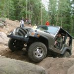
There was a big rock in the sandy trail and we hadn't posed all weekend so we all got up on it for some flex shots. It was one of those "perfect" rocks for flexing so w
e snapped some pictures in the fading light.

We kept going on the trail but it looked more and more like it was going to dead-end. It wasn't on Ladd's GPS and it's not on a topo map. We got to the top of a hill and the road didn't look promising, but we had come a long way so Mike went to check it out. He went around the corner and came out on the trail just above the first fork, so we had made a big circle.

The last part there was very tippy and intimidating on a shelf road with flowers growing in the middle, but we all made it.

This trail was a blast!

clouds
cloudy
columbines
field_of_wildflowers
green_in_the_sun
jon_in_front_of_saint_sophia_ridge
jon_on_the_trail
jon_posing_part_1
jon_posing_part_2
jon_posing_part_3
jon_posing_part_4
ladd_at_the_mountain_top_mine
ladd_on_the_trail
ladd_posing_part_1
ladd_posing_part_2
ladd_posing_part_3
ladd_posing_part_4
lush_green
mike_at_the_edge_part_1
mike_at_the_edge_part_2
mike_on_the_trail
mike_posing_part_1
mike_posing_part_2
mike_posing_part_3
mineral_water
monica_posing_part_1
monica_posing_part_2
monica_posing_part_3
monica_posing_part_4
mountain_top_mine_part_1
mountain_top_mine_part_2
mountain_top_mine_part_3
mountain_top_mine_part_4
mountain_top_mine_shaft
narrow_shelf
overlooking_sidney_basin
purple_wildflower
red_wildflowers
rocks
rocky_arch
saint_sophia_ridge_part_1
saint_sophia_ridge_part_2
saint_sophia_ridge_part_3
saint_sophia_ridge_part_4
sign
sneffels_creek
snowy_peaks
soggy
start_of_the_trail
stony_mountain
sun_on_the_mountains
tight_shelf_road_part_1
tight_shelf_road_part_2
toward_humbolt_mine_part_1
toward_humbolt_mine_part_2
toward_humbolt_mine_part_3
toward_humbolt_mine_part_4
trail_climbing
view_from_mountain_top_mine
view_of_yankee_boy_basin
wet_trail
wildflowers
yellow_wildflower

Report from a Different Day

September 19, 2014

Led by Roger R.
Our objective at the start of the day was to do Black Bear Pass, Imogene Pass, Yankee Boy Basin, and Governor Basin. We had made good time on the Imogene Pass descent and Yankee Boy Basin was a relatively short run, so we continued on and headed up Governor Basin….
Join Us!
If you aren’t a Member or Subscriber, you can’t see all of the content on this site. Get membership information to see why this site is best when you join and log in

Information for Subscribers

When you log in you’ll see more information here:

  • Recent Community Forum posts
  • Recent polls
  • Upcoming Events you can attend
  • Links to online users

© 2000-2022 · TrailDamage.com · Terms and Conditions · About · Contact
Trail information is only accurate on the date posted. Trails may have changed or closed since that date. Use this information for historical purposes only.
Contact the Forest Service or Bureau of Land Management for up-to-date trail information.

/* ----------------------------------------- */ /* View slug: reports-other-reports-for-same-trail-slider - start */ /* ----------------------------------------- */ /* place the prev/next controls on the sides */ .td-transition-controls .wpv-filter-next-link, .td-transition-controls .wpv-filter-previous-link { border: none; font-size: 300%; position: absolute; top: 70px; } .td-transition-controls .wpv-filter-previous-link { left: 0; } .td-transition-controls .wpv-filter-next-link { right: 0; } /* center the page selector horizonatally */ .td-transition-controls ul.wpv_pagination_dots { text-align: center; margin-top: 10px; } /* center the page selector horizonatally */ .td-transition-controls ul.wpv_pagination_dots li.wpv_pagination_dots_item, .td-transition-controls .wpv_pagination_dots li a { display: inline-block; float: none; } /* remove the default styles */ .td-transition-controls .wpv_pagination_dots li a { text-decoration: none; border-bottom: none; } .td-slider-container { padding: 0 25px; margin-bottom: 20px; position: relative; width:100%; display:table; } .td-slides { position: relative; } .td-slides-image { float:left; display:table-cell; } .td-slides-image img { border:1px solid #c0c0c0; } .td-slides-content { padding:4px 4px 4px 10px; border-top:1px solid #c0c0c0; border-right:1px solid #c0c0c0; border-bottom:1px solid #c0c0c0; display:table-cell; height:227px; overflow:hidden; } .td-slides-content h3 { margin-top:8px; } .td-slides-leader { font-size:smaller; margin-top:4px; } /* ----------------------------------------- */ /* View slug: reports-other-reports-for-same-trail-slider - end */ /* ----------------------------------------- */
/* ----------------------------------------- */ /* Content Template: Template for a Single Report - start */ /* ----------------------------------------- */ .entry-header { display:none; } .entry-content h1 { margin-top:16px; padding-top:0; } h1 a { color:#222; } h1 a:hover { color:#666; } p.entry-meta { font-size:small; } #report-body-spacer { clear:both; width:100%; height:20px; } #addtoany-bar { margin-bottom:2em; text-align:center; } .category-reports .post-info .author, .post-info .date { display: none; } .addthis_recommended_horizontal { text-align:center !important; } /* ----------------------------------------- */ /* Content Template: Template for a Single Report - end */ /* ----------------------------------------- */ /* ----------------------------------------- */ /* Content Template: Loop item in REPORTS Runners - start */ /* ----------------------------------------- */ #runners-container { width:100%; clear:both; } .runner { border:1px solid #c0c0c0; margin:0 6px 6px 0; float:left; width:49%; height:81px; } .runner-image { float: left; } .runner-image img { margin:2px 10px 0 2px; height:75px; width:75px; } .runner-name { text-transform:uppercase; } .runner-name a { color:#222; } .runner-name a:hover { color:#666; } .runner-vehicle { font-size:small; } @media only screen and (max-width: 768px) { .runner { width:100%; } } /* ----------------------------------------- */ /* Content Template: Loop item in REPORTS Runners - end */ /* ----------------------------------------- */