TrailDamage.com

Photos, videos and information about 4x4 trails in Colorado and Utah

  • Trails
    • Colorado
    • Utah
  • Reports
    • Featured Photos
    • Featured Videos
    • Reports Calendar
  • Members
  • Search
  • Trail Damage Winners
  • FAQ
  • Community
  • Upcoming Events
  • Membership
  • Log In
  • Facebook
  • Instagram
  • RSS
  • Twitter
  • YouTube

Flat Iron Mesa 061027

October 27, 2006 by Monica

Flat Iron Mesa

Trail Run on October 27, 2006
Report and photos by Monica I., Trail Leader
View trail information for Flat Iron Mesa

Monica I.
Red 2010 Jeep Wrangler Rubicon
Dane R.
Silver 2007 Jeep Wrangler Rubicon
Cheryl W.
Orange 2006 Jeep Wrangler Unlimited Rubicon
Michael M.
Black 2006 Jeep Wrangler Unlimited Rubicon
Bill S.
Yellow 2020 Jeep Wrangler Rubicon

We got a really late start on this trail, which meant that we got to Easter Egg Hill in the dark and watched the sun go down. It made the Squeeze interesting without being able to truly see how big the drop-off was, but it was still scary. We had a great time wheeling it at night.

We found the trailhead easily enough now that we had coordinates, unlike the last time we were on the trail. Following the GPS track made things quite a bit easier.

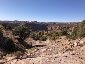
We enjoyed the views as we weaved our way around to Rubble Hill. The hill was fun, and no one had any issues.

We got to the Dome and walked around a bit. We discovered that the last time we had taken the bypass. We found the more difficult trail by descending to the bottom of the Dome, and it was a lot more fun. There were big ledges down there.

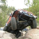
The first big ledge was a blast to drop down. It was big! Then we climbed up a series of other ledges, and those were pretty big too. It ended up really being a fun section in there. We connected with the bypass we had taken last time, and headed off to the rest of the trail.

The sun was going down as we left the easy road to start the second half of the trail. No one had any issues with that first ledge, and we were on our way.

We found Tilt-a-Whirl pretty easily with our GPS coordinates, and we all went down it without a problem. It's a fun obstacle, but it's not particularly difficult. The descent after the obstacle is actually a bit more challenging, with loose rocks and dirt.

We headed off to Easter Egg Hill as the sun finally went down. We all got out to walk the obstacle first, and we all found our own line through it. There were quite a few rocks stacked at the base of the big rock at the top, and it made it a lot easier. No one tipped into the rock on the side.

Almost everyone flexed over the big rock at the bottom, too. It carried your driver-side rear tire in the air as you flexed, and it looked really cool.

At this point we stopped for a bit and sat down to look at the stars, which was really nice. There was just a sliver of a moon, and there were no clouds. It was a bit chilly but not too cold, so we all enjoyed the quiet as we looked at the sky. Sometimes it's the nights on the trail that are the best part of wheeling in Moab.

We had procrastinated enough so we headed off to the Squeeze. It was pretty stressful as we slowly worked our way through it. No one got in any trouble, though, and soon we could all breathe a sigh of relief as we got through the obstacle.

We didn't have an issue finding our way back out to the highway. We didn't want to air up so we slowly got back to town. It was a great day on a great trail!

after_the_dome
big_canyon
big_view_at_the_start
bill_and_michael
bill_climbing
bill_down_a_ledge_part_1
bill_down_a_ledge_part_2
bill_down_rubble_hill_part_1
bill_down_rubble_hill_part_2
bill_down_the_big_ledge
bill_down_tilt-a-whirl_part_1
bill_down_tilt-a-whirl_part_2
bill_down_tilt-a-whirl_part_3
bill_down_tilt-a-whirl_part_4
bill_down_tilt-a-whirl_part_5
bill_up_a_ledge
cheryl_climbing
cheryl_down_a_ledge_part_1
cheryl_down_a_ledge_part_2
cheryl_down_rubble_hill_part_1
cheryl_down_rubble_hill_part_2
cheryl_down_rubble_hill_part_3
cheryl_down_the_big_ledge
cheryl_down_tilt-a-whirl_part_1
cheryl_down_tilt-a-whirl_part_2
cheryl_down_tilt-a-whirl_part_3
cheryl_down_tilt-a-whirl_part_4
cheryl_down_tilt-a-whirl_part_5
cheryl_on_slickrock
cheryl_on_the_trail
cheryl_up_fun_ledges
cool_rocks
dane_and_bill
dane_climbing
dane_down_a_ledge_part_1
dane_down_a_ledge_part_2
dane_down_rubble_hill_part_1
dane_down_rubble_hill_part_2
dane_down_rubble_hill_part_3
dane_down_the_big_ledge
dane_down_the_dome
dane_down_tilt-a-whirl_part_1
dane_down_tilt-a-whirl_part_2
dane_down_tilt-a-whirl_part_3
dane_down_tilt-a-whirl_part_4
dane_down_tilt-a-whirl_part_5
dane_up_fun_ledges
don
down_tilt-a-whirl
early_trail
flat_iron_mesa
fun_ledges
hammerhead_rock
hole
michael_climbing
michael_down_a_ledge_part_1
michael_down_a_ledge_part_2
michael_down_rubble_hill_part_1
michael_down_rubble_hill_part_2
michael_down_the_big_ledge
michael_down_tilt-a-whirl_part_1
michael_down_tilt-a-whirl_part_2
michael_down_tilt-a-whirl_part_3
michael_down_tilt-a-whirl_part_4
michael_down_tilt-a-whirl_part_5
michael_down_tilt-a-whirl_part_6
michael_on_slickrock
michael_up_a_ledge
michael_up_fun_ledges
monica_down_tilt-a-whirl_part_1
monica_down_tilt-a-whirl_part_2
monica_down_tilt-a-whirl_part_3
monica_down_tilt-a-whirl_part_4
monica_down_tilt-a-whirl_part_5
monica_on_the_trail
monica_up_fun_ledges
mountain_view
rocky_climb_at_the_start
rocky
small_ledges
spires
trailhead_part_1
trailhead_part_2
view_from_overlook_1_part_1
view_from_overlook_1_part_2
water

Reports from Other Days: 5

Use the arrows or dots to flip through the previews of the other reports for Flat Iron Mesa. Click one of them to read more and see all of the photos from that day.

October 19, 2019

Led by Matt K.
Flat Iron Mesa was our first trail for Moab in the Fall of 2019. Matt had been wanting to run Flat Iron Mesa for some time, and now his time had finally come! We started at the north end of Flat Iron Mesa and aired down in the parking area…
»
  • 1
  • 2
  • 3
  • 4
  • 5
Join Us!
If you aren’t a Member or Subscriber, you can’t see all of the content on this site. Get membership information to see why this site is best when you join and log in

Information for Subscribers

When you log in you’ll see more information here:

  • Recent Community Forum posts
  • Recent polls
  • Upcoming Events you can attend
  • Links to online users

© 2000-2022 · TrailDamage.com · Terms and Conditions · About · Contact
Trail information is only accurate on the date posted. Trails may have changed or closed since that date. Use this information for historical purposes only.
Contact the Forest Service or Bureau of Land Management for up-to-date trail information.

/* ----------------------------------------- */ /* View slug: reports-other-reports-for-same-trail-slider - start */ /* ----------------------------------------- */ /* place the prev/next controls on the sides */ .td-transition-controls .wpv-filter-next-link, .td-transition-controls .wpv-filter-previous-link { border: none; font-size: 300%; position: absolute; top: 70px; } .td-transition-controls .wpv-filter-previous-link { left: 0; } .td-transition-controls .wpv-filter-next-link { right: 0; } /* center the page selector horizonatally */ .td-transition-controls ul.wpv_pagination_dots { text-align: center; margin-top: 10px; } /* center the page selector horizonatally */ .td-transition-controls ul.wpv_pagination_dots li.wpv_pagination_dots_item, .td-transition-controls .wpv_pagination_dots li a { display: inline-block; float: none; } /* remove the default styles */ .td-transition-controls .wpv_pagination_dots li a { text-decoration: none; border-bottom: none; } .td-slider-container { padding: 0 25px; margin-bottom: 20px; position: relative; width:100%; display:table; } .td-slides { position: relative; } .td-slides-image { float:left; display:table-cell; } .td-slides-image img { border:1px solid #c0c0c0; } .td-slides-content { padding:4px 4px 4px 10px; border-top:1px solid #c0c0c0; border-right:1px solid #c0c0c0; border-bottom:1px solid #c0c0c0; display:table-cell; height:227px; overflow:hidden; } .td-slides-content h3 { margin-top:8px; } .td-slides-leader { font-size:smaller; margin-top:4px; } /* ----------------------------------------- */ /* View slug: reports-other-reports-for-same-trail-slider - end */ /* ----------------------------------------- */
/* ----------------------------------------- */ /* Content Template: Template for a Single Report - start */ /* ----------------------------------------- */ .entry-header { display:none; } .entry-content h1 { margin-top:16px; padding-top:0; } h1 a { color:#222; } h1 a:hover { color:#666; } p.entry-meta { font-size:small; } #report-body-spacer { clear:both; width:100%; height:20px; } #addtoany-bar { margin-bottom:2em; text-align:center; } .category-reports .post-info .author, .post-info .date { display: none; } .addthis_recommended_horizontal { text-align:center !important; } /* ----------------------------------------- */ /* Content Template: Template for a Single Report - end */ /* ----------------------------------------- */ /* ----------------------------------------- */ /* Content Template: Loop item in REPORTS Runners - start */ /* ----------------------------------------- */ #runners-container { width:100%; clear:both; } .runner { border:1px solid #c0c0c0; margin:0 6px 6px 0; float:left; width:49%; height:81px; } .runner-image { float: left; } .runner-image img { margin:2px 10px 0 2px; height:75px; width:75px; } .runner-name { text-transform:uppercase; } .runner-name a { color:#222; } .runner-name a:hover { color:#666; } .runner-vehicle { font-size:small; } @media only screen and (max-width: 768px) { .runner { width:100%; } } /* ----------------------------------------- */ /* Content Template: Loop item in REPORTS Runners - end */ /* ----------------------------------------- */