TrailDamage.com

Photos, videos and information about 4x4 trails in Colorado and Utah

  • Trails
    • Colorado
    • Utah
  • Reports
    • Featured Photos
    • Featured Videos
    • Reports Calendar
  • Members
  • Search
  • Trail Damage Winners
  • FAQ
  • Community
  • Upcoming Events
  • Membership
  • Log In
  • Facebook
  • Instagram
  • RSS
  • Twitter
  • YouTube

Flat Iron Mesa 191019

October 19, 2019 by Matt Kuczborski

Flat Iron Mesa

Trail Run on October 19, 2019
Report and photos by Matt K., Trail Leader
View trail information for Flat Iron Mesa

Niko K.
Gray 2017 Jeep Wrangler Unlimited
Matt K.
White 2016 Jeep Wrangler Unlimited Rubicon

Flat Iron Mesa was our first trail for Moab in the Fall of 2019. Matt had been wanting to run Flat Iron Mesa for some time, and now his time had finally come!

We started at the north end of Flat Iron Mesa and aired down in the parking area near the beginning of the trail. It looked like it was going to be a very nice, warm, and clear day for us.

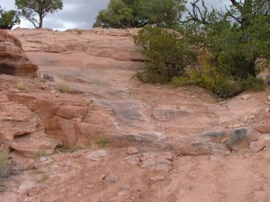
Soon, we started making our way down Flat Iron Mesa. With only two of us, we were able to keep a nice pace. Rubble Hill and the red slickrock Dome did not give us any issues.

Then we were at the Chute. Matt and Niko both went up the Chute with no issues except for the last part of the obstacle. We both tried to go up the very last, steep part of the Chute. There is a bypass for the last part, but we didn’t want to use it. In the end, Matt and Niko got their winches out for a small pull with the winch line. It was fun trying to make it up without the winch, though!

After the Chute, Flat Iron Mesa turned easy and we made good time until we got to Tilt-a-Whirl. We did not have any issues with Tilt-a-Whirl, but we ran into a group of Jeeps making their way down Flat Iron Mesa. We were able to ride with them without any troubles.

Next was Easter Egg Hill. The hard spot for Easter Egg Hill was the steep hill leading up to it. We did okay without any problems with the obstacle, because the big rock in the turn at the start of Easter Egg Hill was moved downhill. We helped guide the other group down Easter Egg Hill and the steep hill right before it.

The last obstacle on this trail is the Intimidator and it does live up to its name. We both did great with Intimidator but spotted each other through it. We helped spot the people from the other group again as they went through the Intimidator. None of them had any issues but for the last Jeep in their group who turned too late and got himself into a tippy spot. We had another Jeep pull him back onto the trail to make sure he wouldn’t go over the side of the cliff. It all worked out and we all drove off to the end of Flat Iron Mesa. It was a great start to our Moab trip.

IMG_5003
IMG_5004
IMG_5005
IMG_5006
IMG_5007
IMG_5008
IMG_5009
IMG_5010
IMG_5011
IMG_5012
IMG_5013
IMG_5014
IMG_5015
IMG_5016
IMG_5019
IMG_5020
IMG_5021
IMG_5023
IMG_5024
IMG_5025
IMG_5026
IMG_5027
IMG_5028
IMG_5029
IMG_5030
IMG_5031
IMG_5032
IMG_5033
IMG_5034
IMG_5035
IMG_5036
IMG_5037
IMG_5039
IMG_5040
IMG_5041
IMG_5042
IMG_5043
IMG_5045
IMG_5046
IMG_5047
IMG_5049
IMG_5051
IMG_5052
IMG_5053
IMG_5054
IMG_5055
IMG_5056
IMG_5057
IMG_5058
IMG_5059
IMG_5060
IMG_5061
IMG_5062
IMG_5063
IMG_5064
IMG_5065
IMG_5066
IMG_5067
IMG_5068
IMG_5069
IMG_5070
IMG_5071
IMG_5073
IMG_5074
IMG_5075
IMG_5076
IMG_5077
IMG_5079

Reports from Other Days: 5

Use the arrows or dots to flip through the previews of the other reports for Flat Iron Mesa. Click one of them to read more and see all of the photos from that day.

October 17, 2004

Led by Monica I.
We were hoping to squeeze in a quick trail before heading home and away from Moab, but it ended up being a little longer than we thought. It was worth it, though! The trail itself was a blast and a nice surprise. You don’t hear about it very often but…
«
  • 1
  • 2
  • 3
  • 4
  • 5
Join Us!
If you aren’t a Member or Subscriber, you can’t see all of the content on this site. Get membership information to see why this site is best when you join and log in

Information for Subscribers

When you log in you’ll see more information here:

  • Recent Community Forum posts
  • Recent polls
  • Upcoming Events you can attend
  • Links to online users

© 2000-2022 · TrailDamage.com · Terms and Conditions · About · Contact
Trail information is only accurate on the date posted. Trails may have changed or closed since that date. Use this information for historical purposes only.
Contact the Forest Service or Bureau of Land Management for up-to-date trail information.

/* ----------------------------------------- */ /* View slug: reports-other-reports-for-same-trail-slider - start */ /* ----------------------------------------- */ /* place the prev/next controls on the sides */ .td-transition-controls .wpv-filter-next-link, .td-transition-controls .wpv-filter-previous-link { border: none; font-size: 300%; position: absolute; top: 70px; } .td-transition-controls .wpv-filter-previous-link { left: 0; } .td-transition-controls .wpv-filter-next-link { right: 0; } /* center the page selector horizonatally */ .td-transition-controls ul.wpv_pagination_dots { text-align: center; margin-top: 10px; } /* center the page selector horizonatally */ .td-transition-controls ul.wpv_pagination_dots li.wpv_pagination_dots_item, .td-transition-controls .wpv_pagination_dots li a { display: inline-block; float: none; } /* remove the default styles */ .td-transition-controls .wpv_pagination_dots li a { text-decoration: none; border-bottom: none; } .td-slider-container { padding: 0 25px; margin-bottom: 20px; position: relative; width:100%; display:table; } .td-slides { position: relative; } .td-slides-image { float:left; display:table-cell; } .td-slides-image img { border:1px solid #c0c0c0; } .td-slides-content { padding:4px 4px 4px 10px; border-top:1px solid #c0c0c0; border-right:1px solid #c0c0c0; border-bottom:1px solid #c0c0c0; display:table-cell; height:227px; overflow:hidden; } .td-slides-content h3 { margin-top:8px; } .td-slides-leader { font-size:smaller; margin-top:4px; } /* ----------------------------------------- */ /* View slug: reports-other-reports-for-same-trail-slider - end */ /* ----------------------------------------- */
/* ----------------------------------------- */ /* Content Template: Template for a Single Report - start */ /* ----------------------------------------- */ .entry-header { display:none; } .entry-content h1 { margin-top:16px; padding-top:0; } h1 a { color:#222; } h1 a:hover { color:#666; } p.entry-meta { font-size:small; } #report-body-spacer { clear:both; width:100%; height:20px; } #addtoany-bar { margin-bottom:2em; text-align:center; } .category-reports .post-info .author, .post-info .date { display: none; } .addthis_recommended_horizontal { text-align:center !important; } /* ----------------------------------------- */ /* Content Template: Template for a Single Report - end */ /* ----------------------------------------- */ /* ----------------------------------------- */ /* Content Template: Loop item in REPORTS Runners - start */ /* ----------------------------------------- */ #runners-container { width:100%; clear:both; } .runner { border:1px solid #c0c0c0; margin:0 6px 6px 0; float:left; width:49%; height:81px; } .runner-image { float: left; } .runner-image img { margin:2px 10px 0 2px; height:75px; width:75px; } .runner-name { text-transform:uppercase; } .runner-name a { color:#222; } .runner-name a:hover { color:#666; } .runner-vehicle { font-size:small; } @media only screen and (max-width: 768px) { .runner { width:100%; } } /* ----------------------------------------- */ /* Content Template: Loop item in REPORTS Runners - end */ /* ----------------------------------------- */