TrailDamage.com

Photos, videos and information about 4x4 trails in Colorado and Utah

  • Trails
    • Colorado
    • Utah
  • Reports
    • Featured Photos
    • Featured Videos
    • Reports Calendar
  • Members
  • Search
  • Trail Damage Winners
  • FAQ
  • Community
  • Upcoming Events
  • Membership
  • Log In
  • Facebook
  • Instagram
  • RSS
  • Twitter
  • YouTube

Eldorado Mountain 071006

October 6, 2007 by Monica

Eldorado Mountain

Trail Run on October 6, 2007
Report and photos by Monica I., Trail Leader
View trail information for Eldorado Mountain

Bob R.
Green 2003 Jeep Wrangler Rubicon
Mike S.
Silver 2004 Jeep Wrangler Rubicon
Don W.
Silver 2005 Jeep Wrangler Rubicon

We had just finished West Magnolia, really enjoying the weather and exploring the mines there. We were looking forward to Eldorado Mountain but not looking forward to trying to find the trailhead.

Like usual, we wandered through the tiny town of Eldora without much luck. We passed some people on ATVs and barely got three words out before they all pointed to the road to the trailhead. We thanked them and took that road up to the trailhead, and finally we were going.

The trail starts out very narrow and doesn't get much wider for a long time. We climbed the bumpy section through dirt portions and portions covered in scree. The views of the gravel pit below us and Barker Reservoir out by Nederland were spectacular.

We were soon out on the exposed area, but it wasn't bad at all. We took the tight switchback and kept climbing, and soon we were surrounded by pine trees. It was a good place to take a break, so we got out to stretch our legs.

It was very peaceful in the trees, and the weather was still gorgeous. No one wanted to leave, but soon we climbed back into our Jeeps and headed out.

We wound our way through the the trees, passing only one other vehicle there. We soon came out into the clearing, climbing over the ridge. When we were at the bottom, a truck started coming down fast. We stopped, noting a place directly in front of us where he could pull to the side. Instead, he bounced off-trail and went by us at a pretty good speed, passing us before we had a chance to flag him down. It was very odd and disappointing.

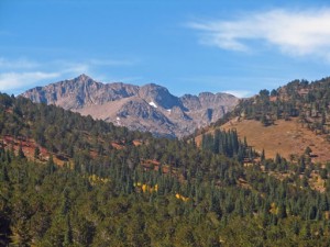
We went over the ridge and down the rocky hill, really enjoying the views. The mountains nearby had snow on them, though the temperatures were very nice.

The rest of the trail isn't particularly scenic, and it was very bumpy. We were pretty quiet as we bounced our way out and to the trailhead for Caribou Creek, which we would do next.

Even with the bouncing, this trail was really pretty. We were really glad we didn't run into anyone in the narrow section.

aspens_part_1
aspens_part_2
blue_sky
climbing
curve
descent
early_aspens
end_of_the_trail
gravel_pit
into_a_clearing
kiosk_sign_1
kiosk_sign_2
kiosk_sign_3
mellow_climb
mountain_view
narrow_trail
pine_trees
shady_climb
sign_near_the_end_of_the_trail
snow_on_mountains
snow_patch
trail_on_scree
trailhead_sign
trailhead
view_of_barker_reservoir_and_nederland
wide_trail
yellow_aspens

Reports from Other Days: 3

Use the arrows or dots to flip through the previews of the other reports for Eldorado Mountain. Click one of them to read more and see all of the photos from that day.

October 1, 2005

Led by Mark F.
After finishing the Caribou Creek trail, we continued southward on the Eldorado Mountain trail. The weather continued to be nice, but more breezy than it was earlier. We met a few northbound cyclists, and passed one large pickup truck in the woods above the narrow shelf road. We wondered if…
« »
  • 1
  • 2
  • 3
Join Us!
If you aren’t a Member or Subscriber, you can’t see all of the content on this site. Get membership information to see why this site is best when you join and log in

Information for Subscribers

When you log in you’ll see more information here:

  • Recent Community Forum posts
  • Recent polls
  • Upcoming Events you can attend
  • Links to online users

© 2000-2021 · TrailDamage.com · Terms and Conditions · About · Contact
Trail information is only accurate on the date posted. Trails may have changed or closed since that date. Use this information for historical purposes only.
Contact the Forest Service or Bureau of Land Management for up-to-date trail information.

/* ----------------------------------------- */ /* View slug: reports-other-reports-for-same-trail-slider - start */ /* ----------------------------------------- */ /* place the prev/next controls on the sides */ .td-transition-controls .wpv-filter-next-link, .td-transition-controls .wpv-filter-previous-link { border: none; font-size: 300%; position: absolute; top: 70px; } .td-transition-controls .wpv-filter-previous-link { left: 0; } .td-transition-controls .wpv-filter-next-link { right: 0; } /* center the page selector horizonatally */ .td-transition-controls ul.wpv_pagination_dots { text-align: center; margin-top: 10px; } /* center the page selector horizonatally */ .td-transition-controls ul.wpv_pagination_dots li.wpv_pagination_dots_item, .td-transition-controls .wpv_pagination_dots li a { display: inline-block; float: none; } /* remove the default styles */ .td-transition-controls .wpv_pagination_dots li a { text-decoration: none; border-bottom: none; } .td-slider-container { padding: 0 25px; margin-bottom: 20px; position: relative; width:100%; display:table; } .td-slides { position: relative; } .td-slides-image { float:left; display:table-cell; } .td-slides-image img { border:1px solid #c0c0c0; } .td-slides-content { padding:4px 4px 4px 10px; border-top:1px solid #c0c0c0; border-right:1px solid #c0c0c0; border-bottom:1px solid #c0c0c0; display:table-cell; height:227px; overflow:hidden; } .td-slides-content h3 { margin-top:8px; } .td-slides-leader { font-size:smaller; margin-top:4px; } /* ----------------------------------------- */ /* View slug: reports-other-reports-for-same-trail-slider - end */ /* ----------------------------------------- */
/* ----------------------------------------- */ /* Content Template: Template for a Single Report - start */ /* ----------------------------------------- */ .entry-header { display:none; } .entry-content h1 { margin-top:16px; padding-top:0; } h1 a { color:#222; } h1 a:hover { color:#666; } p.entry-meta { font-size:small; } #report-body-spacer { clear:both; width:100%; height:20px; } #addtoany-bar { margin-bottom:2em; text-align:center; } .category-reports .post-info .author, .post-info .date { display: none; } .addthis_recommended_horizontal { text-align:center !important; } /* ----------------------------------------- */ /* Content Template: Template for a Single Report - end */ /* ----------------------------------------- */ /* ----------------------------------------- */ /* Content Template: Loop item in REPORTS Runners - start */ /* ----------------------------------------- */ #runners-container { width:100%; clear:both; } .runner { border:1px solid #c0c0c0; margin:0 6px 6px 0; float:left; width:49%; height:81px; } .runner-image { float: left; } .runner-image img { margin:2px 10px 0 2px; height:75px; width:75px; } .runner-name { text-transform:uppercase; } .runner-name a { color:#222; } .runner-name a:hover { color:#666; } .runner-vehicle { font-size:small; } @media only screen and (max-width: 768px) { .runner { width:100%; } } /* ----------------------------------------- */ /* Content Template: Loop item in REPORTS Runners - end */ /* ----------------------------------------- */