TrailDamage.com

Photos, videos and information about 4x4 trails in Colorado and Utah

  • Trails
    • Colorado
    • Utah
  • Reports
    • Featured Photos
    • Featured Videos
    • Reports Calendar
  • Members
  • Search
  • Trail Damage Winners
  • FAQ
  • Community
  • Upcoming Events
  • Membership
  • Log In
  • Facebook
  • Instagram
  • RSS
  • Twitter
  • YouTube

Eagle Rock 160611

June 11, 2016 by Matt Kuczborski

Eagle Rock

Trail Run on June 11, 2016
Report and photos by Matt K., Trail Leader
View trail information for Eagle Rock

Matt K.
White 2016 Jeep Wrangler Unlimited Rubicon
Walt S.
Gray 2022 Jeep Wrangler Unlimited Rubicon 392
Roger R.
Gray 2021 Jeep Wrangler Rubicon 4xe

We met up at Home Depot in Colorado Springs and aired down in the parking lot. The Home Depot had a lot of Jeeps in the parking lot, and we imagined that all of them had the same plan of running Eagle Rock. So, we got in line and we started the long drive down Old Stage Road.

We were actually the first group to get to Eagle Rock. After we went through the small pond of water and came to the clearing, we saw Forest Service crews working with a big group of road trucks and SUVs cleaning up the area. It definitely needed a lot of work, so we were happy to see them.

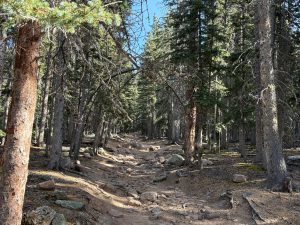
Soon, we were in the rocks on Eagle Rock. The trail looked a lot harder than we remembered from our trip there in 2011. We all had fun climbing over all the rocks on the trail. We eventually picked up another Jeep that stayed behind us for most of the trail.

Just before the first hill climb, Walt had problems with a few spots where he got hung up on rocks. With some spotting help, he made his way up the the rocky hill climb. The rest of us made it up the obstacle without any issues.

Then it was easy going with little rocks here and there to go around. Then, we came to the creek crossing and the hard right turn. We all got a little tippy there, and some of trees got very close to our Jeeps. They didn't get us, though!

Then, we were at a washed-out part of the trail with some big rocks all around us. We all took different lines on the way up, and the left-most line turned out to be the hardest one. Walt ended up getting his driver-side wheel off the ground, but did make his way up.

Near the top of Eagle Rock we got to see some snow still on the ground. Then, we stopped for lunch in a shady area with some trees to sit under. After lunch, we finished Eagle Rock and went back to run Mount Baldy. We did see a sign that Old Stage Road was closed a mile or so from the start of Eagle Rock, so it was good that we weren't heading up in that direction.

airing_down
jeeps_on_the_trail_part_1
jeeps_on_the_trail_part_2
jeeps_on_the_trail_part_3
jeeps_on_the_trail
matt_in_the_creek
matt_in_water
matt_next_to_a_big_rock
matt_on_a_rock
matt_on_the_trail
matt_parked_in_the_shade
rocky_trail
roger_a_little_tippy
roger_in_water
roger_on_the_trail_part_1
roger_on_the_trail_part_2
roger_on_the_trail_part_3
roger_on_the_trail_part_4
roger_on_the_trail_part_5
roger_on_the_trail_part_6
roger_pointing_up
snow
stopped_for_lunch
trail_part_1
trail_part_2
trail_part_3
trail_part_4
view
walt_and_roger
walt_going_up_a_hill_part_1
walt_going_up_a_hill_part_2
walt_going_up_a_hill_part_3
walt_in_water
walt_next_to_a_tree
walt_on_the_trail_part_1
walt_on_the_trail_part_3
walt_on_the_trail_part_4
walt_pointing_up
walt_tippy
walt_with_a_wheel_off_the_ground_part_1
walt_with_a_wheel_off_the_ground_part_2
waterfall

Reports from Other Days: 11

Use the arrows or dots to flip through the previews of the other reports for Eagle Rock. Click one of them to read more and see all of the photos from that day.

April 10, 2022

Led by Jason H.
The day started off at the meetup location, and after some off-topic conversation we headed up to the trailhead. The weather was beautiful but cold and windy. We aired down where the pavement ends on Old Stage Road, and then we were off. At the trailhead we stopped for a…
»
  • 1
  • 2
  • 3
  • 4
  • 5
  • 6
  • 7
  • 8
  • 9
  • 10
  • 11
Join Us!
If you aren’t a Member or Subscriber, you can’t see all of the content on this site. Get membership information to see why this site is best when you join and log in

Information for Subscribers

When you log in you’ll see more information here:

  • Recent Community Forum posts
  • Recent polls
  • Upcoming Events you can attend
  • Links to online users

© 2000-2023 · TrailDamage.com · Terms and Conditions · About · Contact
Trail information is only accurate on the date posted. Trails may have changed or closed since that date. Use this information for historical purposes only.
Contact the Forest Service or Bureau of Land Management for up-to-date trail information.

/* ----------------------------------------- */ /* View slug: reports-other-reports-for-same-trail-slider - start */ /* ----------------------------------------- */ /* place the prev/next controls on the sides */ .td-transition-controls .wpv-filter-next-link, .td-transition-controls .wpv-filter-previous-link { border: none; font-size: 300%; position: absolute; top: 70px; } .td-transition-controls .wpv-filter-previous-link { left: 0; } .td-transition-controls .wpv-filter-next-link { right: 0; } /* center the page selector horizonatally */ .td-transition-controls ul.wpv_pagination_dots { text-align: center; margin-top: 10px; } /* center the page selector horizonatally */ .td-transition-controls ul.wpv_pagination_dots li.wpv_pagination_dots_item, .td-transition-controls .wpv_pagination_dots li a { display: inline-block; float: none; } /* remove the default styles */ .td-transition-controls .wpv_pagination_dots li a { text-decoration: none; border-bottom: none; } .td-slider-container { padding: 0 25px; margin-bottom: 20px; position: relative; width:100%; display:table; } .td-slides { position: relative; } .td-slides-image { float:left; display:table-cell; } .td-slides-image img { border:1px solid #c0c0c0; } .td-slides-content { padding:4px 4px 4px 10px; border-top:1px solid #c0c0c0; border-right:1px solid #c0c0c0; border-bottom:1px solid #c0c0c0; display:table-cell; height:227px; overflow:hidden; } .td-slides-content h3 { margin-top:8px; } .td-slides-leader { font-size:smaller; margin-top:4px; } /* ----------------------------------------- */ /* View slug: reports-other-reports-for-same-trail-slider - end */ /* ----------------------------------------- */
/* ----------------------------------------- */ /* Content Template: Template for a Single Report - start */ /* ----------------------------------------- */ .entry-header { display:none; } .entry-content h1 { margin-top:16px; padding-top:0; } h1 a { color:#222; } h1 a:hover { color:#666; } p.entry-meta { font-size:small; } #report-body-spacer { clear:both; width:100%; height:20px; } #addtoany-bar { margin-bottom:2em; text-align:center; } .category-reports .post-info .author, .post-info .date { display: none; } .addthis_recommended_horizontal { text-align:center !important; } /* ----------------------------------------- */ /* Content Template: Template for a Single Report - end */ /* ----------------------------------------- */ /* ----------------------------------------- */ /* Content Template: Loop item in REPORTS Runners - start */ /* ----------------------------------------- */ #runners-container { width:100%; clear:both; } .runner { border:1px solid #c0c0c0; margin:0 6px 6px 0; float:left; width:49%; height:81px; } .runner-image { float: left; } .runner-image img { margin:2px 10px 0 2px; height:75px; width:75px; } .runner-name { text-transform:uppercase; } .runner-name a { color:#222; } .runner-name a:hover { color:#666; } .runner-vehicle { font-size:small; } @media only screen and (max-width: 768px) { .runner { width:100%; } } /* ----------------------------------------- */ /* Content Template: Loop item in REPORTS Runners - end */ /* ----------------------------------------- */