TrailDamage.com

Photos, videos and information about 4x4 trails in Colorado and Utah

  • Trails
    • Colorado
    • Utah
  • Reports
    • Featured Photos
    • Featured Videos
    • Reports Calendar
  • Members
  • Search
  • Trail Damage Winners
  • FAQ
  • Community
  • Upcoming Events
  • Membership
  • Log In
  • Facebook
  • Instagram
  • RSS
  • Twitter
  • YouTube

Devil’s Canyon 081115

November 15, 2008 by Monica

Devil’s Canyon

Trail Run on November 15, 2008
Report and photos by Monica I., Trail Leader
View trail information for Devil’s Canyon

Ryan S.
Red 1999 Jeep Wrangler
Brian S.
Blue 1997 Jeep Wrangler
Mark F.
Blue 2002 Jeep Wrangler
Chad S.
Blue 2004 Jeep Wrangler
Walt S.
Gray 2018 Jeep Wrangler Unlimited Rubicon
Bob S.
Green 1997 Jeep Wrangler
Ladd G.
Green 2003 Jeep Wrangler Rubicon
Bill S.
Khaki 2004 Jeep Wrangler Rubicon
Monica I.
Red 2010 Jeep Wrangler Rubicon

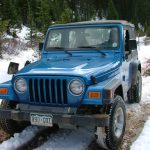
We had just finished Barbour Fork, so we had a good idea what the snow would be like on the trail. They're both in the same general area, though you have to drive for a bit on the pavement to get between the two trails. The snow ended up being just enough to add some fun but not enough to stop any progress.

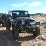
The trailhead snuck up on us, but we all made the turn. We started up, and the hill at the start was steeper than anything we'd found on Barbour Fork. Still, the snow wasn't enough to prevent us from climbing up into the network of trails.

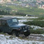
We knew from the maps that there were lots of trail spurs in the area, but we had a plan to make a loop. We did explore one spur, though, that took us almost to the highway where Cascade Creek starts.

It was a pretty steep descent down the spur. A few people stopped before we all got to the bottom where the turnaround was at a dead end. Those of us that went to the bottom just gave it a bunch of momentum and everyone made it up the hill just fine.

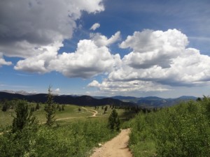
We got back on the main trail and headed up to the overlook at Devil's Hill. We stopped for lunch here, surrounded by scenery. It was sunny, but it was windy here because it was completely exposed. It made for a chilly lunch at times, but everyone enjoyed the company.

But we didn't stay long. We headed back down to the main trail and went around the big loop. There was a tippy spot at the far end that could have been really bad if it was snowy and slick, but luckily it was in the sun. It was on dry dirt, and no one had an issue.

We came around the ridge and then we went over it, back to the four-way intersection by Devil's Hill. After coming over the ridge, we tackled the hill climb to get back over the ridge. This was definitely the most fun section of the trail, and everyone enjoyed the climb.

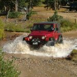
After getting back over the ridge it was pretty quick to get back down to the "Y" intersection and then back to the trailhead. Ladd and Mark had to head for home, but the rest of us went over to add Cascade Creek to our day. Devil's Canyon ended up being a lot of fun.

bare_aspens
bob_and_walt
bumpy
chad_in_scenery
climbing
devils_hill_part_1
devils_hill_part_2
dirt_trail
distant_mountains
early_scenery
elevation
hill_climb_part_1
hill_climb_part_2
little_snow
lunch
monica_and_bill
monica_on_the_trail
no_snow
rocks_above_the_trees
ryan_on_the_trail
seasonal_gate
snow_in_the_shade
snow-capped_mountains
start_of_the_trail
tall_trees
tippy_section
trailhead_sign_1
trailhead_sign_2
trailhead
up_to_devils_hill
view_from_devils_hill_part_1
view_from_devils_hill_part_2

Reports from Other Days: 3

Use the arrows or dots to flip through the previews of the other reports for Devil’s Canyon. Click one of them to read more and see all of the photos from that day.

August 3, 2013

Led by Monica I.
Andy’s back! We haven’t seen him in years, so it was nice to wheel with him again. We spent most of the morning trying to find a back way from Floyd Hill to Idaho Springs via Beaver Brook Canyon Road but it ended at private property, unfortunately. Roads labeled "Jeep…
« »
  • 1
  • 2
  • 3
Join Us!
If you aren’t a Member or Subscriber, you can’t see all of the content on this site. Get membership information to see why this site is best when you join and log in

Information for Subscribers

When you log in you’ll see more information here:

  • Recent Community Forum posts
  • Recent polls
  • Upcoming Events you can attend
  • Links to online users

© 2000-2021 · TrailDamage.com · Terms and Conditions · About · Contact
Trail information is only accurate on the date posted. Trails may have changed or closed since that date. Use this information for historical purposes only.
Contact the Forest Service or Bureau of Land Management for up-to-date trail information.

/* ----------------------------------------- */ /* View slug: reports-other-reports-for-same-trail-slider - start */ /* ----------------------------------------- */ /* place the prev/next controls on the sides */ .td-transition-controls .wpv-filter-next-link, .td-transition-controls .wpv-filter-previous-link { border: none; font-size: 300%; position: absolute; top: 70px; } .td-transition-controls .wpv-filter-previous-link { left: 0; } .td-transition-controls .wpv-filter-next-link { right: 0; } /* center the page selector horizonatally */ .td-transition-controls ul.wpv_pagination_dots { text-align: center; margin-top: 10px; } /* center the page selector horizonatally */ .td-transition-controls ul.wpv_pagination_dots li.wpv_pagination_dots_item, .td-transition-controls .wpv_pagination_dots li a { display: inline-block; float: none; } /* remove the default styles */ .td-transition-controls .wpv_pagination_dots li a { text-decoration: none; border-bottom: none; } .td-slider-container { padding: 0 25px; margin-bottom: 20px; position: relative; width:100%; display:table; } .td-slides { position: relative; } .td-slides-image { float:left; display:table-cell; } .td-slides-image img { border:1px solid #c0c0c0; } .td-slides-content { padding:4px 4px 4px 10px; border-top:1px solid #c0c0c0; border-right:1px solid #c0c0c0; border-bottom:1px solid #c0c0c0; display:table-cell; height:227px; overflow:hidden; } .td-slides-content h3 { margin-top:8px; } .td-slides-leader { font-size:smaller; margin-top:4px; } /* ----------------------------------------- */ /* View slug: reports-other-reports-for-same-trail-slider - end */ /* ----------------------------------------- */
/* ----------------------------------------- */ /* Content Template: Template for a Single Report - start */ /* ----------------------------------------- */ .entry-header { display:none; } .entry-content h1 { margin-top:16px; padding-top:0; } h1 a { color:#222; } h1 a:hover { color:#666; } p.entry-meta { font-size:small; } #report-body-spacer { clear:both; width:100%; height:20px; } #addtoany-bar { margin-bottom:2em; text-align:center; } .category-reports .post-info .author, .post-info .date { display: none; } .addthis_recommended_horizontal { text-align:center !important; } /* ----------------------------------------- */ /* Content Template: Template for a Single Report - end */ /* ----------------------------------------- */ /* ----------------------------------------- */ /* Content Template: Loop item in REPORTS Runners - start */ /* ----------------------------------------- */ #runners-container { width:100%; clear:both; } .runner { border:1px solid #c0c0c0; margin:0 6px 6px 0; float:left; width:49%; height:81px; } .runner-image { float: left; } .runner-image img { margin:2px 10px 0 2px; height:75px; width:75px; } .runner-name { text-transform:uppercase; } .runner-name a { color:#222; } .runner-name a:hover { color:#666; } .runner-vehicle { font-size:small; } @media only screen and (max-width: 768px) { .runner { width:100%; } } /* ----------------------------------------- */ /* Content Template: Loop item in REPORTS Runners - end */ /* ----------------------------------------- */