TrailDamage.com

Photos, videos and information about 4x4 trails in Colorado and Utah

  • Trails
    • Colorado
    • Utah
  • Reports
    • Featured Photos
    • Featured Videos
    • Reports Calendar
  • Members
  • Search
  • Trail Damage Winners
  • FAQ
  • Community
  • Upcoming Events
  • Membership
  • Log In
  • Facebook
  • Instagram
  • RSS
  • Twitter
  • YouTube

Cottonwood Canyon 090523

May 23, 2009 by Monica

Cottonwood Canyon

Trail Run on May 23, 2009
Report and photos by Monica I., Trail Leader
View trail information for Cottonwood Canyon

Jeffrey M.
Khaki 2006 Jeep Wrangler Unlimited Rubicon
Bob S.
Green 1997 Jeep Wrangler
Matt K.
White 2016 Jeep Wrangler Unlimited Rubicon
Walt S.
Gray 2022 Jeep Wrangler Unlimited Rubicon 392
Monica I.
Red 2010 Jeep Wrangler Rubicon
Bill S.
Yellow 2020 Jeep Wrangler Rubicon

We had just finished Pole Canyon Rim and said goodbye to Mike, and the weather was starting to turn. Dark rain clouds were coming in. We figured it would cut our day short, so we explored our options. There were quite a few trails to do in the area, and we decided to explore a new one and do Cottonwood Canyon.

We put doors and windows back in at the trailhead, and right after that it started raining. The trail didn't get slick, and we figured we'd be fine. It wasn't that short, and it would be difficult to turn around, anyway.

When we got to the big hill climb, a few people got out to walk it. Ordinarily it would just be a fun and bouncy climb, but now it was wet and muddy. The rocks looked slick, but looks can be deceiving in Moab.

Monica started up and it turned out to be just fine. The rain let up for a bit, and the wet rocks seemed to be only a little bit slicker than when they were dry. Everyone popped right up the obstacle without any issues.

Bill had told us stories in the past of when he was in the area with another group and they had been on a trail where part of the trail fell away when he was on it. He then remembered that we were on that trail. We might be up for more of an adventure than we thought!

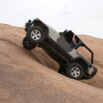
Monica went over a section where she had to cut into the side to get around a washed out portion, but Bill said that wasn't it. Then she got to a narrow section where her Jeep barely fit. Bill said that was it.

Her driver's side tires ran over loose rocks that held the cliff side together. It didn't seem safe. It also didn't sound safe, with the rocks moving under her tires. Still, she just drove right across.

Everyone else did the same thing. Bill was stressed and said it was like that before. We may have been more concerned if we had actually gotten out to look at it, but we didn't. Maybe that saved the rest of us from the stress.

We were soon back out on the road and we discussed going down to the Dolores River just to see how full it was and if it was even crossable. You have to dip into a narrow and low wash to get there, though, and the rain was really coming down. We saw all of the new waterfalls and streams coming down off of the rocks around us and decided that it didn't look like a good idea, so we headed off for town, calling it a day.

When we got to town, we found out that there were flash floods in multiple areas. The highway south of Moab was closed due to a mud slide, and we couldn't even get to our condo without taking back roads. Portions of our condo development were flooded with water and mud, and even we had a water leak. What a mess!

Even though it cut our day short, we were glad we called it early. Luckily, no one was hurt and everyone made it back without an issue.

We had a great dinner together and decided to convoy home in the morning instead of doing another trail. It was a great way to wrap up a great week.

bill_up_the_rocky_climb_part_1
bill_up_the_rocky_climb_part_2
bill_up_the_rocky_climb_part_3
bill_up_the_rocky_climb_part_4
bob_up_the_rocky_climb_part_1
bob_up_the_rocky_climb_part_2
jeffrey_up_the_rocky_climb_part_1
jeffrey_up_the_rocky_climb_part_2
jeffrey_up_the_rocky_climb_part_3
matt_up_the_rocky_climb_part_1
matt_up_the_rocky_climb_part_2
matt_up_the_rocky_climb_part_3
muddy_water
narrow_track
rocky_climb
shelf_road
soggy_jeeps
walt_on_the_trail
waterfall
wet_rocks
Join Us!
If you aren’t a Member or Subscriber, you can’t see all of the content on this site. Get membership information to see why this site is best when you join and log in

Information for Subscribers

When you log in you’ll see more information here:

  • Recent Community Forum posts
  • Recent polls
  • Upcoming Events you can attend
  • Links to online users

© 2000-2022 · TrailDamage.com · Terms and Conditions · About · Contact
Trail information is only accurate on the date posted. Trails may have changed or closed since that date. Use this information for historical purposes only.
Contact the Forest Service or Bureau of Land Management for up-to-date trail information.

/* ----------------------------------------- */ /* View slug: reports-other-reports-for-same-trail-slider - start */ /* ----------------------------------------- */ /* place the prev/next controls on the sides */ .td-transition-controls .wpv-filter-next-link, .td-transition-controls .wpv-filter-previous-link { border: none; font-size: 300%; position: absolute; top: 70px; } .td-transition-controls .wpv-filter-previous-link { left: 0; } .td-transition-controls .wpv-filter-next-link { right: 0; } /* center the page selector horizonatally */ .td-transition-controls ul.wpv_pagination_dots { text-align: center; margin-top: 10px; } /* center the page selector horizonatally */ .td-transition-controls ul.wpv_pagination_dots li.wpv_pagination_dots_item, .td-transition-controls .wpv_pagination_dots li a { display: inline-block; float: none; } /* remove the default styles */ .td-transition-controls .wpv_pagination_dots li a { text-decoration: none; border-bottom: none; } .td-slider-container { padding: 0 25px; margin-bottom: 20px; position: relative; width:100%; display:table; } .td-slides { position: relative; } .td-slides-image { float:left; display:table-cell; } .td-slides-image img { border:1px solid #c0c0c0; } .td-slides-content { padding:4px 4px 4px 10px; border-top:1px solid #c0c0c0; border-right:1px solid #c0c0c0; border-bottom:1px solid #c0c0c0; display:table-cell; height:227px; overflow:hidden; } .td-slides-content h3 { margin-top:8px; } .td-slides-leader { font-size:smaller; margin-top:4px; } /* ----------------------------------------- */ /* View slug: reports-other-reports-for-same-trail-slider - end */ /* ----------------------------------------- */
/* ----------------------------------------- */ /* Content Template: Template for a Single Report - start */ /* ----------------------------------------- */ .entry-header { display:none; } .entry-content h1 { margin-top:16px; padding-top:0; } h1 a { color:#222; } h1 a:hover { color:#666; } p.entry-meta { font-size:small; } #report-body-spacer { clear:both; width:100%; height:20px; } #addtoany-bar { margin-bottom:2em; text-align:center; } .category-reports .post-info .author, .post-info .date { display: none; } .addthis_recommended_horizontal { text-align:center !important; } /* ----------------------------------------- */ /* Content Template: Template for a Single Report - end */ /* ----------------------------------------- */ /* ----------------------------------------- */ /* Content Template: Loop item in REPORTS Runners - start */ /* ----------------------------------------- */ #runners-container { width:100%; clear:both; } .runner { border:1px solid #c0c0c0; margin:0 6px 6px 0; float:left; width:49%; height:81px; } .runner-image { float: left; } .runner-image img { margin:2px 10px 0 2px; height:75px; width:75px; } .runner-name { text-transform:uppercase; } .runner-name a { color:#222; } .runner-name a:hover { color:#666; } .runner-vehicle { font-size:small; } @media only screen and (max-width: 768px) { .runner { width:100%; } } /* ----------------------------------------- */ /* Content Template: Loop item in REPORTS Runners - end */ /* ----------------------------------------- */