TrailDamage.com

Photos, videos and information about 4x4 trails in Colorado and Utah

  • Trails
    • Colorado
    • Utah
  • Reports
    • Featured Photos
    • Featured Videos
    • Reports Calendar
  • Members
  • Search
  • Trail Damage Winners
  • FAQ
  • Community
  • Upcoming Events
  • Membership
  • Log In
  • Facebook
  • Instagram
  • RSS
  • Twitter
  • YouTube

Colorado River Overlook 111014

October 14, 2011 by Monica

Colorado River Overlook

Trail Run on October 14, 2011
Report and photos by Monica I., Trail Leader
View trail information for Colorado River Overlook

Mike S.
Silver 2004 Jeep Wrangler Rubicon
Hoa Q.
Black 1995 Land Rover Range Rover
Monica I.
Red 2010 Jeep Wrangler Rubicon

It was a gorgeous day as we prepared for traveling a lot of miles before the sun went down. We had lots of extra fuel as we headed north on highway 191 to get to Canyonlands National Park. Hoa had some trouble with his guages on the way there but once he turned his vehicle off and back on it went away. He wasn't too worried about it so we pressed on. It was a gorgeous drive.

We stopped at Newspaper Rock to check out the artwork. We took some pictures and talked about how we couldn't believe that people would add their own graffiti to it. It was chilly there in the shade but we could tell it was going to be a nice day.

Once we got to the Visitor Center we aired down in the parking lot. Then we headed to the other side of the lot to the trail and started in. It had been a long time since Monica had been on the trail and it was a new one for Hoa and Mike.

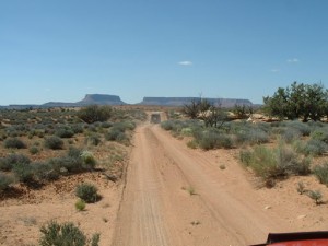
The first part was mellow though we couldn't go too fast because there wasn't much visibility. We were happy to get to some slickrock and Hoa practiced his rockcrawling. We were just happy to be out there.

The rocks were a lot more fun than we remembered. There were shelves here and there and some fun little hills.

Route finding was difficult in spots. It would be nearly impossible in the dark. We expected more from a trail inside the park. We managed to correct our mistakes right away, though, so it wasn't a huge deal.

We had a good trip and we eventually found the end of the trail. We parked and walked around a bit, getting some pictures. Then we decided to break for lunch because it was gorgeous. We got all of our stuff and hiked it out to the end where we had a very scenic break.

But it was soon time to go back. We parked back at the Visitor Center for a break and Mike found the noise he'd been chasing all summer and fixed it (good job!). We sat in the shade at a picnic table for a bit and enjoyed the day. We don't usually take a break like that and it was really nice.

We headed over to Elephant Hill with big plans but when we got there our plans changed. But any day wheeling is a good day.

approaching_the_end
blue_sky
bumpy
climb
first_rocks
follow_the_jeep
formerly_muddy
fun_section
hoa_at_lunch
hoa_on_slickrock_part_1
hoa_on_slickrock_part_2
hoa_on_slickrock_part_3
hoa_on_slickrock_part_4
hoa_on_slickrock_part_5
hoa_on_slickrock_part_6
hoa_taking_pictures
layers
ledges
little_rocks
mike_at_lunch
mike_on_slickrock_part_1
mike_on_slickrock_part_2
mike_on_slickrock_part_3
mike_on_slickrock_part_4
monica_on_slickrock_part_1
monica_on_slickrock_part_2
newspaper_rock_part_1
newspaper_rock_part_2
newspaper_rock_sign
puddle
rock_formations
sandy
sign_at_the_end
slickrock
start_of_the_trail
straight_trail
trailhead_sign_1
trailhead_sign_2
view_at_the_end_part_1
view_at_the_end_part_2
view_at_the_end_part_3
view_at_the_end_part_4
view_at_the_end_part_5
view_at_the_end_part_6
view_at_the_end_part_7

Report from a Different Day

May 13, 2004

Led by Monica I.
We ran this short trail after Elephant Hill because we had some extra time and it sounded fun. Though it was very easy (especially after Elephant Hill) it was worth the drive to check out the view from the Overlook. https://youtu.be/ygZczTxv1jA The majority of the trail was dirt road so…
Join Us!
If you aren’t a Member or Subscriber, you can’t see all of the content on this site. Get membership information to see why this site is best when you join and log in

Information for Subscribers

When you log in you’ll see more information here:

  • Recent Community Forum posts
  • Recent polls
  • Upcoming Events you can attend
  • Links to online users

© 2000-2021 · TrailDamage.com · Terms and Conditions · About · Contact
Trail information is only accurate on the date posted. Trails may have changed or closed since that date. Use this information for historical purposes only.
Contact the Forest Service or Bureau of Land Management for up-to-date trail information.

/* ----------------------------------------- */ /* View slug: reports-other-reports-for-same-trail-slider - start */ /* ----------------------------------------- */ /* place the prev/next controls on the sides */ .td-transition-controls .wpv-filter-next-link, .td-transition-controls .wpv-filter-previous-link { border: none; font-size: 300%; position: absolute; top: 70px; } .td-transition-controls .wpv-filter-previous-link { left: 0; } .td-transition-controls .wpv-filter-next-link { right: 0; } /* center the page selector horizonatally */ .td-transition-controls ul.wpv_pagination_dots { text-align: center; margin-top: 10px; } /* center the page selector horizonatally */ .td-transition-controls ul.wpv_pagination_dots li.wpv_pagination_dots_item, .td-transition-controls .wpv_pagination_dots li a { display: inline-block; float: none; } /* remove the default styles */ .td-transition-controls .wpv_pagination_dots li a { text-decoration: none; border-bottom: none; } .td-slider-container { padding: 0 25px; margin-bottom: 20px; position: relative; width:100%; display:table; } .td-slides { position: relative; } .td-slides-image { float:left; display:table-cell; } .td-slides-image img { border:1px solid #c0c0c0; } .td-slides-content { padding:4px 4px 4px 10px; border-top:1px solid #c0c0c0; border-right:1px solid #c0c0c0; border-bottom:1px solid #c0c0c0; display:table-cell; height:227px; overflow:hidden; } .td-slides-content h3 { margin-top:8px; } .td-slides-leader { font-size:smaller; margin-top:4px; } /* ----------------------------------------- */ /* View slug: reports-other-reports-for-same-trail-slider - end */ /* ----------------------------------------- */
/* ----------------------------------------- */ /* Content Template: Template for a Single Report - start */ /* ----------------------------------------- */ .entry-header { display:none; } .entry-content h1 { margin-top:16px; padding-top:0; } h1 a { color:#222; } h1 a:hover { color:#666; } p.entry-meta { font-size:small; } #report-body-spacer { clear:both; width:100%; height:20px; } #addtoany-bar { margin-bottom:2em; text-align:center; } .category-reports .post-info .author, .post-info .date { display: none; } .addthis_recommended_horizontal { text-align:center !important; } /* ----------------------------------------- */ /* Content Template: Template for a Single Report - end */ /* ----------------------------------------- */ /* ----------------------------------------- */ /* Content Template: Loop item in REPORTS Runners - start */ /* ----------------------------------------- */ #runners-container { width:100%; clear:both; } .runner { border:1px solid #c0c0c0; margin:0 6px 6px 0; float:left; width:49%; height:81px; } .runner-image { float: left; } .runner-image img { margin:2px 10px 0 2px; height:75px; width:75px; } .runner-name { text-transform:uppercase; } .runner-name a { color:#222; } .runner-name a:hover { color:#666; } .runner-vehicle { font-size:small; } @media only screen and (max-width: 768px) { .runner { width:100%; } } /* ----------------------------------------- */ /* Content Template: Loop item in REPORTS Runners - end */ /* ----------------------------------------- */