TrailDamage.com

Photos, videos and information about 4x4 trails in Colorado and Utah

  • Trails
    • Colorado
    • Utah
  • Reports
    • Featured Photos
    • Featured Videos
    • Reports Calendar
  • Members
  • Search
  • Trail Damage Winners
  • FAQ
  • Community
  • Upcoming Events
  • Membership
  • Log In
  • Facebook
  • Instagram
  • RSS
  • Twitter
  • YouTube

Clear Lake 080828

August 28, 2008 by Monica

Clear Lake

Trail Run on August 28, 2008
Report and photos by Monica I., Trail Leader
View trail information for Clear Lake

Michael M.
Black 2006 Jeep Wrangler Unlimited Rubicon
Walt S.
Gray 2018 Jeep Wrangler Unlimited Rubicon
Monica I.
Red 2010 Jeep Wrangler Rubicon

We started a gorgeous but long day with the Clear Lake trail. Michael had done it before, but it was new to the rest of us. The weather was perfect, and it ended up being one of the most beautiful trails we'd see the entire week.

We barely left Silverton and we were already at the trailhead. We aired down a bit to smooth out the bumpy spots, and then we were off. The early trail was very easy, but the scenery couldn't be beat. We saw many lucky RVs and other campers in the valley.

We made the right turn and started heading up the switchbacks. The trail immediately turned a bit rougher, but it was still pretty easy. The switchbacks weren't too tight, and there seemed to be room to pass other vehicles most of the time. In fact, we passed two vehicles carrying researchers on their way down. They were doing research up at Clear Lake.

The trail was nice in the trees, but when we came out of them the view was absolutely amazing. You could see for miles, and the sky was a gorgeous blue. We could see our trail switchbacking up the mountain ahead of us, and we thought it might be a rough one. Luckily, it just looked scary from the bottom -- it turned out to be a shelf road at times but usually a pretty mellow one.

We could soon see the waterfall ahead of us, and we couldn't wait to check it out. There was plenty of parking room at the switchback, and we were excited to walk to the water. Unfortunately, you couldn't walk very far. But we could get close enough for some great pictures. We stayed for awhile, enjoying the scenery and listening to the water.

We swung by the mine at the next switchback, but it was boarded up and no one got out. That meant we were soon on our way.

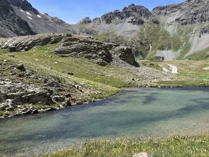
It got a little tight in places in the last half-mile, but then it opened up and we were at Clear Lake. There was good parking, and we were excited to get out and see it. You could definitely see why they call it Clear Lake. You could see the bottom of the lake, even when it was pretty deep.

Michael said that he'd done some fishing there recently, and that the fishing was good. He still enjoyed the trip up, even though he'd just seen it.

We saw the research being done up there, along with a sign explaining it. We also saw some hikers. Everyone was very happy, and it was a great way to start our day.

We soon headed back down, anxious to check out the other trails. We had a lot planned, but we could do it all. Right?

airing_down
approaching_timberline
bear_mountain
burbank_mine
clear_lake_part_1
clear_lake_part_2
clear_lake_part_3
clear_lake_part_4
clear_lake_part_5
clear_lake_part_6
clear_lake_part_7
clear_lake_research_note
climbing
colorful
don_in_scenery
down_from_the_lake
early_bridge
early_trail
gulch
jeeps_at_the_waterfall
michael_at_clear_lake
mineral_creek
monica_at_clear_lake
mountain_stream_part_1
mountain_stream_part_2
nearing_the_end
parked_at_clear_lake
ridge
snaking_trail
start_of_the_trail
stripes
trailhead_sign_1
trailhead_sign_2
trailhead_sign_3
trailhead_sign_4
trailhead_signs
turn_right_here
ulysses_s_grant_peak
walt_at_clear_lake
water_crossing_at_spur
waterfall
wet_trail
Join Us!
If you aren’t a Member or Subscriber, you can’t see all of the content on this site. Get membership information to see why this site is best when you join and log in

Information for Subscribers

When you log in you’ll see more information here:

  • Recent Community Forum posts
  • Recent polls
  • Upcoming Events you can attend
  • Links to online users

© 2000-2021 · TrailDamage.com · Terms and Conditions · About · Contact
Trail information is only accurate on the date posted. Trails may have changed or closed since that date. Use this information for historical purposes only.
Contact the Forest Service or Bureau of Land Management for up-to-date trail information.

/* ----------------------------------------- */ /* View slug: reports-other-reports-for-same-trail-slider - start */ /* ----------------------------------------- */ /* place the prev/next controls on the sides */ .td-transition-controls .wpv-filter-next-link, .td-transition-controls .wpv-filter-previous-link { border: none; font-size: 300%; position: absolute; top: 70px; } .td-transition-controls .wpv-filter-previous-link { left: 0; } .td-transition-controls .wpv-filter-next-link { right: 0; } /* center the page selector horizonatally */ .td-transition-controls ul.wpv_pagination_dots { text-align: center; margin-top: 10px; } /* center the page selector horizonatally */ .td-transition-controls ul.wpv_pagination_dots li.wpv_pagination_dots_item, .td-transition-controls .wpv_pagination_dots li a { display: inline-block; float: none; } /* remove the default styles */ .td-transition-controls .wpv_pagination_dots li a { text-decoration: none; border-bottom: none; } .td-slider-container { padding: 0 25px; margin-bottom: 20px; position: relative; width:100%; display:table; } .td-slides { position: relative; } .td-slides-image { float:left; display:table-cell; } .td-slides-image img { border:1px solid #c0c0c0; } .td-slides-content { padding:4px 4px 4px 10px; border-top:1px solid #c0c0c0; border-right:1px solid #c0c0c0; border-bottom:1px solid #c0c0c0; display:table-cell; height:227px; overflow:hidden; } .td-slides-content h3 { margin-top:8px; } .td-slides-leader { font-size:smaller; margin-top:4px; } /* ----------------------------------------- */ /* View slug: reports-other-reports-for-same-trail-slider - end */ /* ----------------------------------------- */
/* ----------------------------------------- */ /* Content Template: Template for a Single Report - start */ /* ----------------------------------------- */ .entry-header { display:none; } .entry-content h1 { margin-top:16px; padding-top:0; } h1 a { color:#222; } h1 a:hover { color:#666; } p.entry-meta { font-size:small; } #report-body-spacer { clear:both; width:100%; height:20px; } #addtoany-bar { margin-bottom:2em; text-align:center; } .category-reports .post-info .author, .post-info .date { display: none; } .addthis_recommended_horizontal { text-align:center !important; } /* ----------------------------------------- */ /* Content Template: Template for a Single Report - end */ /* ----------------------------------------- */ /* ----------------------------------------- */ /* Content Template: Loop item in REPORTS Runners - start */ /* ----------------------------------------- */ #runners-container { width:100%; clear:both; } .runner { border:1px solid #c0c0c0; margin:0 6px 6px 0; float:left; width:49%; height:81px; } .runner-image { float: left; } .runner-image img { margin:2px 10px 0 2px; height:75px; width:75px; } .runner-name { text-transform:uppercase; } .runner-name a { color:#222; } .runner-name a:hover { color:#666; } .runner-vehicle { font-size:small; } @media only screen and (max-width: 768px) { .runner { width:100%; } } /* ----------------------------------------- */ /* Content Template: Loop item in REPORTS Runners - end */ /* ----------------------------------------- */