TrailDamage.com

Photos, videos and information about 4x4 trails in Colorado and Utah

  • Trails
    • Colorado
    • Utah
  • Reports
    • Featured Photos
    • Featured Videos
    • Reports Calendar
  • Members
  • Search
  • Trail Damage Winners
  • FAQ
  • Community
  • Upcoming Events
  • Membership
  • Log In
  • Facebook
  • Instagram
  • RSS
  • Twitter
  • YouTube

Chinaman Gulch 090425

April 25, 2009 by Matt Kuczborski

Chinaman Gulch

Trail Run on April 25, 2009
Report and photos by Matt K., Trail Leader
View trail information for Chinaman Gulch

Roger R.
Gray 2021 Jeep Wrangler Rubicon 4xe
Matt K.
White 2016 Jeep Wrangler Unlimited Rubicon
Jeffrey M.
Khaki 2006 Jeep Wrangler Unlimited Rubicon

Chinaman Gulch is a great trail to run, and that's why it's one of our favorites. The weather for the day was great - not too hot and not too cold. When we met at Johnson Village we were a half-hour earlier than we thought we'd be, so we got to the trail early and aired down all before 10AM. We started down the trail for what promised to be a very nice run.

The Rock Garden was a lot harder than we remembered, but none of us ended up having any issues. We did have a group of Jeeps catch up with us while we were playing in the Rock Garden. They ended up running most of the trail with us and they even had lunch with our group.

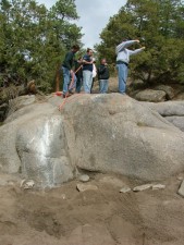
The trail up to the Rock Pile was easy going. Matt and Jeffrey played on the Rock Pile, and Matt drove over the obstacle without any problems. Jeffrey had a little harder time. Apparently, having the longer wheel base made it harder for him to get through the pile of big rocks.

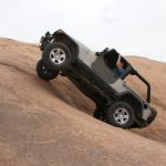
The next obstacle was Whale's Tail. The trail up to Whale's Tail had a few rocks to drive over or around if you could, and we enjoyed the trip. The Whale's tail was easy for all of us if we went up the center of it. Roger said that Matt went up too quickly for him to take a picture of Matt in the obstacle, but Roger went up even faster and Matt could not get a picture of Roger going up Whale's Tail either.

Then we were off to the Stairs, the next obstacle. The trail to the Stairs was fun, as it had big rocks that you had to go up and over. There were no bypasses for most of this part of the trail. Just before the Stairs we found an area to pull over and stop for lunch.

The Stairs made for a fun challenge and we all made it without any issues, going up the right side. None of us would have made it up the left side. This is where we split ways with the other group that we were wheeling with for most of the day.

The Chutes were next. It's only a short drive from the Stairs to that obstacle. We all went up easily. It looked like it was going to be harder than it ended up being, and no one had any trouble with it.

Then the last part of the trail was very tippy at times just before you get back to the Rock Garden again. The drive out is the same as the drive in, only going in the other direction. It's definitely fun in both directions.

The Chinaman Gulch trail has eroded a lot in the last couple of years. We all agreed that a stock Jeep Wrangler would have a bit more trouble driving the trail now compared to past years. But we really enjoyed the challenges.

OLYMPUS DIGITAL CAMERA

Reports from Other Days: 24

Use the arrows or dots to flip through the previews of the other reports for Chinaman Gulch. Click one of them to read more and see all of the photos from that day.

October 30, 2004

Led by Ladd G.
We met in Conifer at 8AM and we were on the trail at 10:45AM. It was 47 degrees when we started but the temperature got up to 71 degrees and we didn’t see a cloud in the sky. We saw several deer throughout the day, too. They finally got the…
« »
  • 1
  • 2
  • 3
  • 4
  • 5
  • 6
  • 7
  • 8
  • 9
  • 10
  • 11
  • 12
  • 13
  • 14
  • 15
  • 16
  • 17
  • 18
  • 19
  • 20
  • 21
  • 22
  • 23
  • 24
Join Us!
If you aren’t a Member or Subscriber, you can’t see all of the content on this site. Get membership information to see why this site is best when you join and log in

Information for Subscribers

When you log in you’ll see more information here:

  • Recent Community Forum posts
  • Recent polls
  • Upcoming Events you can attend
  • Links to online users

© 2000-2022 · TrailDamage.com · Terms and Conditions · About · Contact
Trail information is only accurate on the date posted. Trails may have changed or closed since that date. Use this information for historical purposes only.
Contact the Forest Service or Bureau of Land Management for up-to-date trail information.

/* ----------------------------------------- */ /* View slug: reports-other-reports-for-same-trail-slider - start */ /* ----------------------------------------- */ /* place the prev/next controls on the sides */ .td-transition-controls .wpv-filter-next-link, .td-transition-controls .wpv-filter-previous-link { border: none; font-size: 300%; position: absolute; top: 70px; } .td-transition-controls .wpv-filter-previous-link { left: 0; } .td-transition-controls .wpv-filter-next-link { right: 0; } /* center the page selector horizonatally */ .td-transition-controls ul.wpv_pagination_dots { text-align: center; margin-top: 10px; } /* center the page selector horizonatally */ .td-transition-controls ul.wpv_pagination_dots li.wpv_pagination_dots_item, .td-transition-controls .wpv_pagination_dots li a { display: inline-block; float: none; } /* remove the default styles */ .td-transition-controls .wpv_pagination_dots li a { text-decoration: none; border-bottom: none; } .td-slider-container { padding: 0 25px; margin-bottom: 20px; position: relative; width:100%; display:table; } .td-slides { position: relative; } .td-slides-image { float:left; display:table-cell; } .td-slides-image img { border:1px solid #c0c0c0; } .td-slides-content { padding:4px 4px 4px 10px; border-top:1px solid #c0c0c0; border-right:1px solid #c0c0c0; border-bottom:1px solid #c0c0c0; display:table-cell; height:227px; overflow:hidden; } .td-slides-content h3 { margin-top:8px; } .td-slides-leader { font-size:smaller; margin-top:4px; } /* ----------------------------------------- */ /* View slug: reports-other-reports-for-same-trail-slider - end */ /* ----------------------------------------- */
/* ----------------------------------------- */ /* Content Template: Template for a Single Report - start */ /* ----------------------------------------- */ .entry-header { display:none; } .entry-content h1 { margin-top:16px; padding-top:0; } h1 a { color:#222; } h1 a:hover { color:#666; } p.entry-meta { font-size:small; } #report-body-spacer { clear:both; width:100%; height:20px; } #addtoany-bar { margin-bottom:2em; text-align:center; } .category-reports .post-info .author, .post-info .date { display: none; } .addthis_recommended_horizontal { text-align:center !important; } /* ----------------------------------------- */ /* Content Template: Template for a Single Report - end */ /* ----------------------------------------- */ /* ----------------------------------------- */ /* Content Template: Loop item in REPORTS Runners - start */ /* ----------------------------------------- */ #runners-container { width:100%; clear:both; } .runner { border:1px solid #c0c0c0; margin:0 6px 6px 0; float:left; width:49%; height:81px; } .runner-image { float: left; } .runner-image img { margin:2px 10px 0 2px; height:75px; width:75px; } .runner-name { text-transform:uppercase; } .runner-name a { color:#222; } .runner-name a:hover { color:#666; } .runner-vehicle { font-size:small; } @media only screen and (max-width: 768px) { .runner { width:100%; } } /* ----------------------------------------- */ /* Content Template: Loop item in REPORTS Runners - end */ /* ----------------------------------------- */