TrailDamage.com

Photos, videos and information about 4x4 trails in Colorado and Utah

  • Trails
    • Colorado
    • Utah
  • Reports
    • Featured Photos
    • Featured Videos
    • Reports Calendar
  • Members
  • Search
  • Trail Damage Winners
  • FAQ
  • Community
  • Upcoming Events
  • Membership
  • Log In
  • Facebook
  • Instagram
  • RSS
  • Twitter
  • YouTube

The Causeway 111012

October 12, 2011 by Monica

The Causeway

Trail Run on October 12, 2011
Report and photos by Monica I., Trail Leader
View trail information for The Causeway

Mike S.
Silver 2004 Jeep Wrangler Rubicon
Hoa Q.
Black 1995 Land Rover Range Rover
Monica I.
Red 2010 Jeep Wrangler Rubicon

We were really looking forward to seeing the Causeway. It looked very impressive on the topo maps and the trail was very twisty. We had already done the far west end of it but we turned off to do the Mormon Pasture Mountain trail. After that, we ran The Causeway.

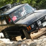
We followed some dump trucks as we went over the Reef of Rocks. We must have been between shifts after that, though, because we didn't see many dump trucks after that. We saw other cars, though.

We passed other spurs leading both north and south into the canyons next to us. We didn't have time to run them, though, so we made plans for other days in the future. So many trails, so little time!

The Chippean Rocks were especially cool. We could see them sticking out up over the big pine trees around us. We went around a big curve and saw the spur to the overlook next to the trail. The spur looked fun and we needed to use 4-wheel drive so we took it.

It was a nice climb to the top though it was short. There was a turnaround at the top around a huge bush. We decided to stop there for lunch even though it was insanely windy and a bit chilly. We found a place where the vehicles blocked the wind and sat down to enjoy the scenery. You could really see for miles in almost any direction and we really liked the views.

But we had to get back to wheeling eventually so we soon headed back down. The spur was fun on the way down, too. It was really cool when we came out to the bridge over The Causeway at its narrowest end. What a sight! It was narrow there but then it widened into a canyon miles across.

There wasn't anywhere to park so we didn't stop there. Instead, we went a bit farther to the spur for the next overlook. It was a bit of a walk but completely worth it. The views of the Causeway were amazing and we took lots of pictures.

After that overlook we stopped a couple of times at wide spots in the road to check out the view. It was hard to drive at times because it was so distracting. Hoa and Mike had cigars and life was good.

When we got to the trailhead we had some confusion finding the next trail, North Creek Pass. But it all worked out and we were on our way. We'll definitely be back to the Causeway to check out those other trails.

break_time
burned_tree
colors
cool_branches
crater
curve
dried_branch
dry_wash_reservoir_sign
dry_wash_reservoir
easy_trail
following_the_causeway
heading_down
hoa_down_from_the_overlook
hoa_on_the_trail
hoa_taking_pictures_part_1
hoa_taking_pictures_part_2
hoa_taking_pictures_part_3
holes_in_rock
little_dry_mesa_sign
mellow
mike_down_from_the_overlook
mike_on_the_trail
monica_on_the_trail
monica_taking_pictures
open_area
parked_at_lunch
ridge
skyline_trail_sign
straight_trail
the_causeway_part_1
the_causeway_part_2
the_causeway_part_3
the_causeway_part_4
the_causeway_part_5
the_causeway_part_6
the_causeway_part_7
the_causeway_part_8
the_causeway_part_9
three_spires
trailhead_sign
trailhead_signs
trees_and_shadows
trees_of_many_colors
tuerto_canyon_sign
view_from_overlook_1_part_1
view_from_overlook_1_part_2
view_from_overlook_1_part_3
wavy
weird_tree
well_maintained
west_end
white_dirt
woodpecker_damage
Join Us!
If you aren’t a Member or Subscriber, you can’t see all of the content on this site. Get membership information to see why this site is best when you join and log in

Information for Subscribers

When you log in you’ll see more information here:

  • Recent Community Forum posts
  • Recent polls
  • Upcoming Events you can attend
  • Links to online users

© 2000-2021 · TrailDamage.com · Terms and Conditions · About · Contact
Trail information is only accurate on the date posted. Trails may have changed or closed since that date. Use this information for historical purposes only.
Contact the Forest Service or Bureau of Land Management for up-to-date trail information.

/* ----------------------------------------- */ /* View slug: reports-other-reports-for-same-trail-slider - start */ /* ----------------------------------------- */ /* place the prev/next controls on the sides */ .td-transition-controls .wpv-filter-next-link, .td-transition-controls .wpv-filter-previous-link { border: none; font-size: 300%; position: absolute; top: 70px; } .td-transition-controls .wpv-filter-previous-link { left: 0; } .td-transition-controls .wpv-filter-next-link { right: 0; } /* center the page selector horizonatally */ .td-transition-controls ul.wpv_pagination_dots { text-align: center; margin-top: 10px; } /* center the page selector horizonatally */ .td-transition-controls ul.wpv_pagination_dots li.wpv_pagination_dots_item, .td-transition-controls .wpv_pagination_dots li a { display: inline-block; float: none; } /* remove the default styles */ .td-transition-controls .wpv_pagination_dots li a { text-decoration: none; border-bottom: none; } .td-slider-container { padding: 0 25px; margin-bottom: 20px; position: relative; width:100%; display:table; } .td-slides { position: relative; } .td-slides-image { float:left; display:table-cell; } .td-slides-image img { border:1px solid #c0c0c0; } .td-slides-content { padding:4px 4px 4px 10px; border-top:1px solid #c0c0c0; border-right:1px solid #c0c0c0; border-bottom:1px solid #c0c0c0; display:table-cell; height:227px; overflow:hidden; } .td-slides-content h3 { margin-top:8px; } .td-slides-leader { font-size:smaller; margin-top:4px; } /* ----------------------------------------- */ /* View slug: reports-other-reports-for-same-trail-slider - end */ /* ----------------------------------------- */
/* ----------------------------------------- */ /* Content Template: Template for a Single Report - start */ /* ----------------------------------------- */ .entry-header { display:none; } .entry-content h1 { margin-top:16px; padding-top:0; } h1 a { color:#222; } h1 a:hover { color:#666; } p.entry-meta { font-size:small; } #report-body-spacer { clear:both; width:100%; height:20px; } #addtoany-bar { margin-bottom:2em; text-align:center; } .category-reports .post-info .author, .post-info .date { display: none; } .addthis_recommended_horizontal { text-align:center !important; } /* ----------------------------------------- */ /* Content Template: Template for a Single Report - end */ /* ----------------------------------------- */ /* ----------------------------------------- */ /* Content Template: Loop item in REPORTS Runners - start */ /* ----------------------------------------- */ #runners-container { width:100%; clear:both; } .runner { border:1px solid #c0c0c0; margin:0 6px 6px 0; float:left; width:49%; height:81px; } .runner-image { float: left; } .runner-image img { margin:2px 10px 0 2px; height:75px; width:75px; } .runner-name { text-transform:uppercase; } .runner-name a { color:#222; } .runner-name a:hover { color:#666; } .runner-vehicle { font-size:small; } @media only screen and (max-width: 768px) { .runner { width:100%; } } /* ----------------------------------------- */ /* Content Template: Loop item in REPORTS Runners - end */ /* ----------------------------------------- */