TrailDamage.com

Photos, videos and information about 4x4 trails in Colorado and Utah

  • Trails
    • Colorado
    • Utah
  • Reports
    • Featured Photos
    • Featured Videos
    • Reports Calendar
  • Members
  • Search
  • Trail Damage Winners
  • FAQ
  • Community
  • Upcoming Events
  • Membership
  • Log In
  • Facebook
  • Instagram
  • RSS
  • Twitter
  • YouTube

Carnage Canyon LHC 070930

September 30, 2007 by Monica

Carnage Canyon LHC

Trail Run on September 30, 2007
Report and photos by Monica I., Trail Leader
View trail information for Carnage Canyon LHC

Chad S.
Blue 2004 Jeep Wrangler
Monica I.
Red 2010 Jeep Wrangler Rubicon

We were going to explore the Left Hand Canyon area of trails in order to fully map everything, especially the Five Points area. We started with Carnage Canyon and found ourselves in traffic right away.

While we were airing up, someone came up to ask us if we were meeting a bunch of people. He was supposed to meet a group but they didn't show up. We chatted for a bit, but then we left him there to start the trail.

There were a lot of shooters in the first section of Left Hand Canyon, and the place was pretty trashed. There was a lot of junk that they were all shooting at, and it was so destroyed by bullets that you couldn't tell what it used to be. It looked like appliances and other metal and plastic items. The trail itself was littered with shells.

Once we were past the shooters it mellowed out and we came up on two vehicles. We were skipping most of the big obstacles so we ended up passing them when they stopped to play on the side of the trail. It was impossible to tell which sections were legal and which were off-trail, like usual. We did our best to estimate what was correct.

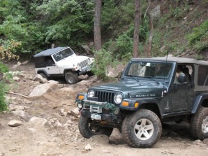
When we got to the first rocks we caught up with another group. We followed them for a bit, and then they were behind someone else who was broken and stuck in the trail. We had to go off-trail to get around the stuck vehicle, following an illegal trail up and around him. The illegal trail was pretty well-used.

We skipped the Waterfall and went around it, though the bypass around it was also slick and difficult in spots. We both made it through without incident, though.

When we got to the turnoff for Fireman Hill, the group in front of us took it. We kept going to Five Points and found ourselves alone.

We went up Upper Carnage and had a much different experience. It was peaceful and fun, and because of the fencing you could always tell that you were on the correct trail. It's good to know that you aren't destroying anything.

We took Upper Carnage as far as it would go, going to just past the Squeeze on Left Hand Canyon before intersecting with that trail. Then we followed Left Hand Canyon up to the upper kiosk.

We had lunch at that point, and took some time to check out the maps and signs on the kiosk. It was relaxing and we only saw two vehicles come up Castle Gulch while we were there.

When we finished lunch we headed down Fireman Hill. It was a pretty good start on Carnage Canyon, all things considered. No one broke anything!

airing_down_part_1
airing_down_part_2
broken_beer_bottle
chad_around_the_waterfall
chad_in_rocks_part_1
chad_in_rocks_part_2
chad_in_rocks_part_3
chad_in_rocks_part_4
chad_in_rocks_part_5
chad_in_rocks_part_6
chad_on_the_trail
colorful
destroyed_forest_service_sign
early_rocks
mellow_section_before_rocks
monica_on_the_trail
shooter_trash_part_1
shooter_trash_part_2
shooter_trash_part_3
shooter_trash_part_4
start_of_the_trail
the_slab_part_1
the_slab_part_2
trailhead_sign
upper_carnage_part_1
upper_carnage_part_2
view_from_upper_carnage

Reports from Other Days: 8

Use the arrows or dots to flip through the previews of the other reports for Carnage Canyon LHC. Click one of them to read more and see all of the photos from that day.

August 5, 2007

Led by Ladd G.
We decided to go for a little wheeling late Sunday afternoon. We got to the trailhead for Left Hand Canyon sometime after 4PM, where we aired down and disconnected our sway bars. We were soon on our way. We braved the shooting range to get to Carnage Canyon. Gun smoke…
»
  • 1
  • 2
  • 3
  • 4
  • 5
  • 6
  • 7
  • 8
Join Us!
If you aren’t a Member or Subscriber, you can’t see all of the content on this site. Get membership information to see why this site is best when you join and log in

Information for Subscribers

When you log in you’ll see more information here:

  • Recent Community Forum posts
  • Recent polls
  • Upcoming Events you can attend
  • Links to online users

© 2000-2021 · TrailDamage.com · Terms and Conditions · About · Contact
Trail information is only accurate on the date posted. Trails may have changed or closed since that date. Use this information for historical purposes only.
Contact the Forest Service or Bureau of Land Management for up-to-date trail information.

/* ----------------------------------------- */ /* View slug: reports-other-reports-for-same-trail-slider - start */ /* ----------------------------------------- */ /* place the prev/next controls on the sides */ .td-transition-controls .wpv-filter-next-link, .td-transition-controls .wpv-filter-previous-link { border: none; font-size: 300%; position: absolute; top: 70px; } .td-transition-controls .wpv-filter-previous-link { left: 0; } .td-transition-controls .wpv-filter-next-link { right: 0; } /* center the page selector horizonatally */ .td-transition-controls ul.wpv_pagination_dots { text-align: center; margin-top: 10px; } /* center the page selector horizonatally */ .td-transition-controls ul.wpv_pagination_dots li.wpv_pagination_dots_item, .td-transition-controls .wpv_pagination_dots li a { display: inline-block; float: none; } /* remove the default styles */ .td-transition-controls .wpv_pagination_dots li a { text-decoration: none; border-bottom: none; } .td-slider-container { padding: 0 25px; margin-bottom: 20px; position: relative; width:100%; display:table; } .td-slides { position: relative; } .td-slides-image { float:left; display:table-cell; } .td-slides-image img { border:1px solid #c0c0c0; } .td-slides-content { padding:4px 4px 4px 10px; border-top:1px solid #c0c0c0; border-right:1px solid #c0c0c0; border-bottom:1px solid #c0c0c0; display:table-cell; height:227px; overflow:hidden; } .td-slides-content h3 { margin-top:8px; } .td-slides-leader { font-size:smaller; margin-top:4px; } /* ----------------------------------------- */ /* View slug: reports-other-reports-for-same-trail-slider - end */ /* ----------------------------------------- */
/* ----------------------------------------- */ /* Content Template: Template for a Single Report - start */ /* ----------------------------------------- */ .entry-header { display:none; } .entry-content h1 { margin-top:16px; padding-top:0; } h1 a { color:#222; } h1 a:hover { color:#666; } p.entry-meta { font-size:small; } #report-body-spacer { clear:both; width:100%; height:20px; } #addtoany-bar { margin-bottom:2em; text-align:center; } .category-reports .post-info .author, .post-info .date { display: none; } .addthis_recommended_horizontal { text-align:center !important; } /* ----------------------------------------- */ /* Content Template: Template for a Single Report - end */ /* ----------------------------------------- */ /* ----------------------------------------- */ /* Content Template: Loop item in REPORTS Runners - start */ /* ----------------------------------------- */ #runners-container { width:100%; clear:both; } .runner { border:1px solid #c0c0c0; margin:0 6px 6px 0; float:left; width:49%; height:81px; } .runner-image { float: left; } .runner-image img { margin:2px 10px 0 2px; height:75px; width:75px; } .runner-name { text-transform:uppercase; } .runner-name a { color:#222; } .runner-name a:hover { color:#666; } .runner-vehicle { font-size:small; } @media only screen and (max-width: 768px) { .runner { width:100%; } } /* ----------------------------------------- */ /* Content Template: Loop item in REPORTS Runners - end */ /* ----------------------------------------- */