TrailDamage.com

Photos, videos and information about 4x4 trails in Colorado and Utah

  • Trails
    • Colorado
    • Utah
  • Reports
    • Featured Photos
    • Featured Videos
    • Reports Calendar
  • Members
  • Search
  • Trail Damage Winners
  • FAQ
  • Community
  • Upcoming Events
  • Membership
  • Log In
  • Facebook
  • Instagram
  • RSS
  • Twitter
  • YouTube

Boxcar Bridge 100519

May 19, 2010 by Monica

Boxcar Bridge

Trail Run on May 19, 2010
Report and photos by Monica I., Trail Leader
View trail information for Boxcar Bridge

Andrew W.
Gray 2002 Jeep Wrangler
Robert M.
Green 1987 Jeep Wrangler
Roger R.
Gray 2021 Jeep Wrangler Rubicon 4xe
Mark U.
Red 1989 Jeep Wrangler

We hadn't even been over in that area south of Moab so we were looking forward to checking out the scenery. We also didn't really know what to expect from the trail. It was going to be a good start to a fun week in Moab.

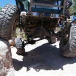
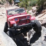
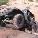
Mark and Robert had been working on their Jeeps for awhile, long enough to fall off of the "current members" list for the group. Both of their Jeeps started out as fairly standard YJ models but ended up with lots of modifications. This was the first trail run for both of them since doing all of the upgrades, and both were pretty excited to see how their "new" rigs would do on the trails.

Andrew had driven all night from Texas, arriving in Moab early that morning. We hoped he wouldn't just pass out on the trail.

The trail started out on an easy dirt road where we aired down to smooth out the bumps. We stopped at Looking Glass Rock and almost everyone hiked up into the arch. Everyone had a grin from ear to ear. That's a good way to start the trip!

We ended up starting the network of trails at the end of the trail, running the rest of it in the opposite direction. It would have been a bit more fun running it as it's described here on the Web site, so we'll do that next time.

That meant that we hit the wash right away instead of at the end. It was very green, especially for Moab. We stopped for a little bit to enjoy the shade and the scenery.

We had a marker on the GPS for Boxcar Bridge, but we didn't have any idea what it was. Was it a natural bridge or something man-made? Was it something made out of a boxcar? We got out of the Jeeps and looked all over the place, but no one found anything. It was disappointing.

Soon after looking for the bridge, we stopped for lunch. We had a nice, leisurely lunch, and as we were packing up we spotted Boxcar Bridge up on a ridge. It was just a coincidence! It turned out that it was a natural bridge.

We cut through a ravine soon after lunch, and that was pretty fun. Soon after that, the trail became very straight and easy. We turned to stay as close to the mesa's edge as we could, heading for what we hoped was an overlook.

We found the overlook, but we couldn't get as close to the edge as we'd hoped. Still, the views were good. Mark and Robert tested their flex by driving up on each other's tires. Everyone was impressed. Wow!

We soon found our way out and we were on the gravel road. We headed out to Anticline Overlook to do the Canyon Rim Overlooks trail. Boxcar Bridge ended up being a fun trail.

airing_down
andrew_in_scenery
andrew_on_the_trail
big_view
bit_of_slickrock
boxcar_bridge
bumpy
cactus
cave_house
curvy
dirt_trail
easy_trail
few_trees
following_36
following_paint
fun_climb
fun_stuff
getting_rougher
great_view
greenery
in_looking_glass_arch
in_the_wash
la_sal_mountains_hidden_in_clouds
la_sal_mountains_in_the_distance
lone_butte
long_section
looking_glass_arch_part_1
looking_glass_arch_part_2
mark_and_robert
mark_at_looking_glass_arch
mark_flex_part_1
mark_flex_part_2
mark_flex_part_3
marked_as_difficult
mellow_trail
moab_stuff
over_the_top
robert_flex_part_1
robert_flex_part_2
robert_flex_part_3
robert_on_the_trail
robert_with_last-minute_fixes
roger_on_the_dirt
roger_on_the_trail
sign_at_the_start
start_of_the_trail
through_trees
up_to_looking_glass_arch_part_1
up_to_looking_glass_arch_part_2
up_to_looking_glass_arch_part_3
up_to_looking_glass_arch_part_4
up_to_looking_glass_arch_part_5
view_from_looking_glass_arch
Join Us!
If you aren’t a Member or Subscriber, you can’t see all of the content on this site. Get membership information to see why this site is best when you join and log in

Information for Subscribers

When you log in you’ll see more information here:

  • Recent Community Forum posts
  • Recent polls
  • Upcoming Events you can attend
  • Links to online users

© 2000-2022 · TrailDamage.com · Terms and Conditions · About · Contact
Trail information is only accurate on the date posted. Trails may have changed or closed since that date. Use this information for historical purposes only.
Contact the Forest Service or Bureau of Land Management for up-to-date trail information.

/* ----------------------------------------- */ /* View slug: reports-other-reports-for-same-trail-slider - start */ /* ----------------------------------------- */ /* place the prev/next controls on the sides */ .td-transition-controls .wpv-filter-next-link, .td-transition-controls .wpv-filter-previous-link { border: none; font-size: 300%; position: absolute; top: 70px; } .td-transition-controls .wpv-filter-previous-link { left: 0; } .td-transition-controls .wpv-filter-next-link { right: 0; } /* center the page selector horizonatally */ .td-transition-controls ul.wpv_pagination_dots { text-align: center; margin-top: 10px; } /* center the page selector horizonatally */ .td-transition-controls ul.wpv_pagination_dots li.wpv_pagination_dots_item, .td-transition-controls .wpv_pagination_dots li a { display: inline-block; float: none; } /* remove the default styles */ .td-transition-controls .wpv_pagination_dots li a { text-decoration: none; border-bottom: none; } .td-slider-container { padding: 0 25px; margin-bottom: 20px; position: relative; width:100%; display:table; } .td-slides { position: relative; } .td-slides-image { float:left; display:table-cell; } .td-slides-image img { border:1px solid #c0c0c0; } .td-slides-content { padding:4px 4px 4px 10px; border-top:1px solid #c0c0c0; border-right:1px solid #c0c0c0; border-bottom:1px solid #c0c0c0; display:table-cell; height:227px; overflow:hidden; } .td-slides-content h3 { margin-top:8px; } .td-slides-leader { font-size:smaller; margin-top:4px; } /* ----------------------------------------- */ /* View slug: reports-other-reports-for-same-trail-slider - end */ /* ----------------------------------------- */
/* ----------------------------------------- */ /* Content Template: Template for a Single Report - start */ /* ----------------------------------------- */ .entry-header { display:none; } .entry-content h1 { margin-top:16px; padding-top:0; } h1 a { color:#222; } h1 a:hover { color:#666; } p.entry-meta { font-size:small; } #report-body-spacer { clear:both; width:100%; height:20px; } #addtoany-bar { margin-bottom:2em; text-align:center; } .category-reports .post-info .author, .post-info .date { display: none; } .addthis_recommended_horizontal { text-align:center !important; } /* ----------------------------------------- */ /* Content Template: Template for a Single Report - end */ /* ----------------------------------------- */ /* ----------------------------------------- */ /* Content Template: Loop item in REPORTS Runners - start */ /* ----------------------------------------- */ #runners-container { width:100%; clear:both; } .runner { border:1px solid #c0c0c0; margin:0 6px 6px 0; float:left; width:49%; height:81px; } .runner-image { float: left; } .runner-image img { margin:2px 10px 0 2px; height:75px; width:75px; } .runner-name { text-transform:uppercase; } .runner-name a { color:#222; } .runner-name a:hover { color:#666; } .runner-vehicle { font-size:small; } @media only screen and (max-width: 768px) { .runner { width:100%; } } /* ----------------------------------------- */ /* Content Template: Loop item in REPORTS Runners - end */ /* ----------------------------------------- */