TrailDamage.com

Photos, videos and information about 4x4 trails in Colorado and Utah

  • Trails
    • Colorado
    • Utah
  • Reports
    • Featured Photos
    • Featured Videos
    • Reports Calendar
  • Members
  • Search
  • Trail Damage Winners
  • FAQ
  • Community
  • Upcoming Events
  • Membership
  • Log In
  • Facebook
  • Instagram
  • RSS
  • Twitter
  • YouTube

Book Cliffs 081101

November 1, 2008 by Monica

Book Cliffs

Trail Run on November 1, 2008
Report and photos by Monica I., Trail Leader
View trail information for Book Cliffs

Monica I.
Red 2010 Jeep Wrangler Rubicon
Mike S.
Silver 2004 Jeep Wrangler Rubicon
Jeffrey M.
Khaki 2006 Jeep Wrangler Unlimited Rubicon
Michael M.
Black 2006 Jeep Wrangler Unlimited Rubicon

We had already put on a lot of miles for one day, but we really wanted to do the Book Cliffs trail before we called it a day. We still had a couple of hours of daylight left, so we headed out.

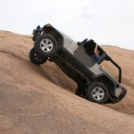
The trail was very easy to find, and very easy to travel. It was graded, so it was usually pretty smooth. Unfortunately, that also made it pretty dusty.

We turned off at the first overlook, lazy and mellow from driving such a smooth trail. The overlook spur woke us up a bit, with a few rocks and twists through the brush.

The overlook itself was amazing, with some gorgeous views of Crescent Junction, the area we're so familiar with. It's always a happy place, the I-70 exit where you turn to go to Moab. It was really awe-inspiring.

We got back to the trail and instantly got mellow again because the trail was so smooth. The scenery was pretty cool, traveling along the Book Cliffs, but after awhile they do tend to look the same. After such a long week, it made us sleepy.

The second overlook was short but interesting compared to the main trail. The scenery was also fantastic. It was good to get out and stretch our legs, too.

It wasn't long after that when we were at the main road. We realized that we didn't have enough light left to do Sego Canyon, another trail, so we headed off to the old town of Sego to do some sightseeing before heading out.

The old town was really cool, and we hung out for quite awhile pointing things out to each other. It must have been a really cool town.

We also stopped at the petroglyphs and walked around. It was very cool, and the signs were very informative.

We stayed at the last one to air up and reconnect while we lost the last of our light. We were all done and ready to go when Monica pulled the knob to turn on her lights and the whole knob came out in her hand.

We definitely needed headlights to get back to Moab, so the guys got together to figure out how to fix it. They hit the broken part hard enough to get it to go to the first position, enough to turn on the tail lights and running lights -- and Monica's super-bright auxiliary lights. She ran like that all the way back to Moab without any issues. Those lights are almost as bright as headlights anyway.

Unfortunately, no headlights meant that Monica was done and had to go home early the next day. Everyone else decided to go home, too, so Sego Canyon would have to wait for another trip.

We had a great time in Moab, as always, and we really saw a lot of new sights this time. Moab is always such a blast!

approaching_the_book_cliffs
awesome_bluff
big_view
colors
cowboy_cabin_part_1
cowboy_cabin_part_2
cowboy_cabin_part_3
creek_crossing_1
creek_crossing_2
curved_trail
few_trees
heading_up
interesting_formations
layers
majestic
narrow_point
sandy
start_of_the_trail
stripes
tall
to_overlook_1
to_overlook_2
trailhead_sign
view_from_overlook_1_part_1
view_from_overlook_1_part_2
view_from_overlook_1_part_3
view_from_overlook_2_part_1
view_from_overlook_2_part_2
view_from_overlook_2_part_3
wavy
Join Us!
If you aren’t a Member or Subscriber, you can’t see all of the content on this site. Get membership information to see why this site is best when you join and log in

Information for Subscribers

When you log in you’ll see more information here:

  • Recent Community Forum posts
  • Recent polls
  • Upcoming Events you can attend
  • Links to online users

© 2000-2023 · TrailDamage.com · Terms and Conditions · About · Contact
Trail information is only accurate on the date posted. Trails may have changed or closed since that date. Use this information for historical purposes only.
Contact the Forest Service or Bureau of Land Management for up-to-date trail information.

/* ----------------------------------------- */ /* View slug: reports-other-reports-for-same-trail-slider - start */ /* ----------------------------------------- */ /* place the prev/next controls on the sides */ .td-transition-controls .wpv-filter-next-link, .td-transition-controls .wpv-filter-previous-link { border: none; font-size: 300%; position: absolute; top: 70px; } .td-transition-controls .wpv-filter-previous-link { left: 0; } .td-transition-controls .wpv-filter-next-link { right: 0; } /* center the page selector horizonatally */ .td-transition-controls ul.wpv_pagination_dots { text-align: center; margin-top: 10px; } /* center the page selector horizonatally */ .td-transition-controls ul.wpv_pagination_dots li.wpv_pagination_dots_item, .td-transition-controls .wpv_pagination_dots li a { display: inline-block; float: none; } /* remove the default styles */ .td-transition-controls .wpv_pagination_dots li a { text-decoration: none; border-bottom: none; } .td-slider-container { padding: 0 25px; margin-bottom: 20px; position: relative; width:100%; display:table; } .td-slides { position: relative; } .td-slides-image { float:left; display:table-cell; } .td-slides-image img { border:1px solid #c0c0c0; } .td-slides-content { padding:4px 4px 4px 10px; border-top:1px solid #c0c0c0; border-right:1px solid #c0c0c0; border-bottom:1px solid #c0c0c0; display:table-cell; height:227px; overflow:hidden; } .td-slides-content h3 { margin-top:8px; } .td-slides-leader { font-size:smaller; margin-top:4px; } /* ----------------------------------------- */ /* View slug: reports-other-reports-for-same-trail-slider - end */ /* ----------------------------------------- */
/* ----------------------------------------- */ /* Content Template: Template for a Single Report - start */ /* ----------------------------------------- */ .entry-header { display:none; } .entry-content h1 { margin-top:16px; padding-top:0; } h1 a { color:#222; } h1 a:hover { color:#666; } p.entry-meta { font-size:small; } #report-body-spacer { clear:both; width:100%; height:20px; } #addtoany-bar { margin-bottom:2em; text-align:center; } .category-reports .post-info .author, .post-info .date { display: none; } .addthis_recommended_horizontal { text-align:center !important; } /* ----------------------------------------- */ /* Content Template: Template for a Single Report - end */ /* ----------------------------------------- */ /* ----------------------------------------- */ /* Content Template: Loop item in REPORTS Runners - start */ /* ----------------------------------------- */ #runners-container { width:100%; clear:both; } .runner { border:1px solid #c0c0c0; margin:0 6px 6px 0; float:left; width:49%; height:81px; } .runner-image { float: left; } .runner-image img { margin:2px 10px 0 2px; height:75px; width:75px; } .runner-name { text-transform:uppercase; } .runner-name a { color:#222; } .runner-name a:hover { color:#666; } .runner-vehicle { font-size:small; } @media only screen and (max-width: 768px) { .runner { width:100%; } } /* ----------------------------------------- */ /* Content Template: Loop item in REPORTS Runners - end */ /* ----------------------------------------- */