TrailDamage.com

Photos, videos and information about 4x4 trails in Colorado and Utah

  • Trails
    • Colorado
    • Utah
  • Reports
    • Featured Photos
    • Featured Videos
    • Reports Calendar
  • Members
  • Search
  • Trail Damage Winners
  • FAQ
  • Community
  • Upcoming Events
  • Membership
  • Log In
  • Facebook
  • Instagram
  • RSS
  • Twitter
  • YouTube

Blanding Cutoff 101020

October 20, 2010 by Monica

Blanding Cutoff

Trail Run on October 20, 2010
Report and photos by Monica I., Trail Leader
View trail information for Blanding Cutoff

Monica I.
Red 2010 Jeep Wrangler Rubicon
Walt S.
Gray 2022 Jeep Wrangler Unlimited Rubicon 392

Note that the Blanding Cutoff was run on October 20th but it was dark, so pictures were not taken. We returned on October 22nd to take some pictures but could not complete the trail due to the previous night's rain. The associated pictures are actually from October 22nd, 2010.

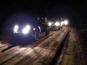
It was dark when we came off of Woodenshoe Buttes, and it made finding the Blanding Cutoff a definite challenge. A few trails and spurs all connect at the west end of the trail, and Monica couldn't find the correct one in the dark. She looped around and eventually ended up back with Walt at the confusing area. It took some exploring but we eventually found our way hiding in plain sight in the dark.

The trail was easy, and we couldn't see much. We could tell that the climb on the west end was next to a cliff, though, so we were careful. The section in the middle was easy, and the descent wasn't too bad at all.

It wasn't long before we were back in Blanding. We had an unsatisfying dinner in town and called it a night.

We had a great day of trail runs on October 21st, and then it started raining. It rained hard all through the night and it was raining off and on on the 22nd when we got up. We decided to risk a trail even though people in town said it was dangerous. We should have listened.

We figured we'd go over to the Blanding Cutoff to get some pictures. The trail was slick and muddy at first, and as we went it kept getting deeper and stickier. We started heading down on the other side and Monica realized that she was pretty much out of control, heading toward a curve on a shelf road. She stopped midway down the hill and Walt stopped at the top.

The mud was very deep and very sticky. It was difficult to walk in, and very difficult to drive on. The cliff was pretty steep, and it was slow and steady work getting the Jeeps turned around and back to relative safety. We were very careful getting back to town.

Walt ended up spending a fortune at the car wash trying to get the mud out of his suddenly out-of-balance wheels. We had our trail lunches at the hotel and decided just to take the day off. It was a bummer (and the first time we've had to do it) but there was too much rain and the mud had too much clay in it to be safe.

Still, we got some pictures of the trail. It all worked itself out, and everyone had a nice nap before dinner.

brush
curve
fall_colors
getting_slicker
gravel
hot_pockets!
jeeps_and_footprints
long_stretch
low_clouds
monica_muddy
mud_curve
pavement_end
rock_outcropping
sloppy
valley_view
walt_muddy_part_1
walt_muddy_part_2
walt_muddy_part_3
walt_muddy_part_4
walt_muddy
water_crossing

Report from a Different Day

October 14, 2011

Led by Monica I.
We had just completed a lot of miles of trails and we found ourselves on Cottonwood Wash, heading for Blanding and the hotel. The sun was completely down. Why not add another trail to the mix? Monica had done the Blanding Cutoff trail before but it was new to Mike…
Join Us!
If you aren’t a Member or Subscriber, you can’t see all of the content on this site. Get membership information to see why this site is best when you join and log in

Information for Subscribers

When you log in you’ll see more information here:

  • Recent Community Forum posts
  • Recent polls
  • Upcoming Events you can attend
  • Links to online users

© 2000-2022 · TrailDamage.com · Terms and Conditions · About · Contact
Trail information is only accurate on the date posted. Trails may have changed or closed since that date. Use this information for historical purposes only.
Contact the Forest Service or Bureau of Land Management for up-to-date trail information.

/* ----------------------------------------- */ /* View slug: reports-other-reports-for-same-trail-slider - start */ /* ----------------------------------------- */ /* place the prev/next controls on the sides */ .td-transition-controls .wpv-filter-next-link, .td-transition-controls .wpv-filter-previous-link { border: none; font-size: 300%; position: absolute; top: 70px; } .td-transition-controls .wpv-filter-previous-link { left: 0; } .td-transition-controls .wpv-filter-next-link { right: 0; } /* center the page selector horizonatally */ .td-transition-controls ul.wpv_pagination_dots { text-align: center; margin-top: 10px; } /* center the page selector horizonatally */ .td-transition-controls ul.wpv_pagination_dots li.wpv_pagination_dots_item, .td-transition-controls .wpv_pagination_dots li a { display: inline-block; float: none; } /* remove the default styles */ .td-transition-controls .wpv_pagination_dots li a { text-decoration: none; border-bottom: none; } .td-slider-container { padding: 0 25px; margin-bottom: 20px; position: relative; width:100%; display:table; } .td-slides { position: relative; } .td-slides-image { float:left; display:table-cell; } .td-slides-image img { border:1px solid #c0c0c0; } .td-slides-content { padding:4px 4px 4px 10px; border-top:1px solid #c0c0c0; border-right:1px solid #c0c0c0; border-bottom:1px solid #c0c0c0; display:table-cell; height:227px; overflow:hidden; } .td-slides-content h3 { margin-top:8px; } .td-slides-leader { font-size:smaller; margin-top:4px; } /* ----------------------------------------- */ /* View slug: reports-other-reports-for-same-trail-slider - end */ /* ----------------------------------------- */
/* ----------------------------------------- */ /* Content Template: Template for a Single Report - start */ /* ----------------------------------------- */ .entry-header { display:none; } .entry-content h1 { margin-top:16px; padding-top:0; } h1 a { color:#222; } h1 a:hover { color:#666; } p.entry-meta { font-size:small; } #report-body-spacer { clear:both; width:100%; height:20px; } #addtoany-bar { margin-bottom:2em; text-align:center; } .category-reports .post-info .author, .post-info .date { display: none; } .addthis_recommended_horizontal { text-align:center !important; } /* ----------------------------------------- */ /* Content Template: Template for a Single Report - end */ /* ----------------------------------------- */ /* ----------------------------------------- */ /* Content Template: Loop item in REPORTS Runners - start */ /* ----------------------------------------- */ #runners-container { width:100%; clear:both; } .runner { border:1px solid #c0c0c0; margin:0 6px 6px 0; float:left; width:49%; height:81px; } .runner-image { float: left; } .runner-image img { margin:2px 10px 0 2px; height:75px; width:75px; } .runner-name { text-transform:uppercase; } .runner-name a { color:#222; } .runner-name a:hover { color:#666; } .runner-vehicle { font-size:small; } @media only screen and (max-width: 768px) { .runner { width:100%; } } /* ----------------------------------------- */ /* Content Template: Loop item in REPORTS Runners - end */ /* ----------------------------------------- */