TrailDamage.com

Photos, videos and information about 4x4 trails in Colorado and Utah

  • Trails
    • Colorado
    • Utah
  • Reports
    • Featured Photos
    • Featured Videos
    • Reports Calendar
  • Members
  • Search
  • Trail Damage Winners
  • FAQ
  • Community
  • Upcoming Events
  • Membership
  • Log In
  • Facebook
  • Instagram
  • RSS
  • Twitter
  • YouTube

Black Bear Pass 170908

September 8, 2017 by Monica

Black Bear Pass

Trail Run on September 8, 2017
Report and photos by Monica I., Trail Leader
View trail information for Black Bear Pass

Niko K.
Gray 2017 Jeep Wrangler Unlimited
Walt S.
Gray 2018 Jeep Wrangler Unlimited Rubicon
Monica I.
Red 2010 Jeep Wrangler Rubicon

If you're in Ouray, the "classic" day is to do Black Bear Pass and Imogene Pass in a big loop, and that was our plan.  We met in town and then headed out to the trailhead, airing down when it was still pretty early in the morning.  That would give us lots of time to relax and enjoy the trip.  We passed all of the warning signs and headed up the trail.

The skies were hazy from fires in the northwest and southwest United States, so visibility wasn't as good as it usually was.  We hoped the sun would clear things up for us as the day progressed.  The side trip to the overlook was nice, and we were pointing things out all over the place.  We stopped at the wide meadow so Niko could get his drone set up, and it followed us for a bit.  

We were surprised to find a bypass around the series of ledges with water running down them.  Of course, we all did the obstacle and had a great time taking all different lines up it.  We wanted to check out the bypass, too, so we looped around to do the obstacle again.  It was a great way to start the day.

It didn't take long to get to Black Bear Pass, and we enjoyed the views but didn't get out.  It was pretty windy.  Then we headed down.

The trail is pretty and not too challenging as you come down to the basin, but then the trail starts descending pretty steeply and the obstacles start.  We got out to look over a chunky hill with big holes in it before heading down, and it was pretty crazy to have that so close to the edge.

Of course, that was nothing compared to the shelf road and corner.  Monica drove slowly and carefully, and it all went well.  Niko and Walt also took their time around the dangerous corner.  None of us had any issues with the switchback, and then we all parked to get out at Ingram Falls.  It's definitely a scenic area, and we spent some time there exploring and looking down at the switchbacks and Telluride.

There was a bit of a tippy section just past the falls, and then we got to the switchback where people have gone off the side and had so much trouble.  It's not a particularly tight switchback, but if you screwed up and got too close to the edge or if you had mechanical troubles you'd likely die in the accident when you went over the side.  It's definitely intimidating.  But we took it slow, spotting each other.  No one even needed too many points in their turn, and we were soon through it.

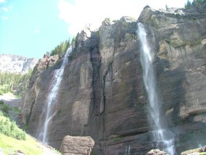
After that, the switchbacks were easy.  There were SUVs and hikers all over the place.  It looked like they were doing work on the Powerhouse, so we didn't stop near it.  When we got to Bridal Veil Falls, we were a bit sad to see the hiking trail to the base of the falls was pretty much gone.  A flood had come through and it was torn up, with big boulders and mounds of dirt and logs in the way.  We hoped they would fix it at some point, but for now it was definitely closed.  We met some cool people there, though, and Niko had some more fun with his drone.

The trail's end had been rerouted since we were there last, around private property.  Route finding was easy, though, and we were soon off the trail.  We stopped at the park near the base of the trail and had a nice lunch next to a pond with ducks begging for food.  We'd definitely do that again.  When lunch was over, we headed through town to Imogene Pass.

DSC01606
DSC01608
DSC01610
DSC01611
DSC01612
DSC01613
DSC01614
DSC01615
DSC01616
DSC01617
DSC01618
DSC01619
DSC01620
DSC01621
DSC01622
DSC01623
DSC01624
DSC01625
DSC01626
DSC01627
DSC01628
DSC01630
DSC01631
DSC01632
DSC01633
DSC01634
DSC01635
DSC01636
DSC01637
DSC01638
DSC01639
DSC01640
DSC01641
DSC01642
DSC01643
DSC01644
DSC01645
DSC01647
DSC01648
DSC01650
DSC01651
DSC01652
DSC01653
DSC01654
DSC01655
DSC01656
DSC01657
DSC01658
DSC01659
DSC01660
DSC01661
DSC01662
DSC01664
DSC01665
DSC01666
DSC01667
DSC01668
DSC01669
DSC01670
DSC01671
DSC01672
DSC01673
DSC01674
DSC01675
DSC01676
DSC01677
DSC01678
DSC01679
DSC01680
DSC01681
DSC01682
DSC01683
DSC01684
DSC01685
DSC01686
DSC01687
DSC01688
DSC01690
DSC01691
DSC01692
DSC01693
DSC01694
DSC01696
DSC01697
DSC01699
DSC01701
DSC01702
DSC01704
DSC01705
DSC01706
DSC01707
DSC01708
DSC01711
DSC01712
DSC01713
DSC01714
DSC01715
DSC01716
DSC01718
DSC01719
DSC01720
DSC01721
DSC01722
DSC01723
DSC01724
DSC01725
DSC01726
DSC01727
DSC01728
DSC01729
DSC01732
DSC01733
DSC01734
DSC01735
DSC01737
DSC01738
DSC01739
DSC01740
DSC01741
DSC01742
DSC01743
DSC01744
DSC01745
DSC01746
DSC01747
DSC01748
DSC01749
DSC01750
DSC01751
DSC01753
DSC01754
DSC01755
DSC01756
DSC01758
DSC01759
DSC01760
DSC01761
DSC01763
DSC01764
DSC01765
DSC01766
DSC01767
DSC01768
DSC01769
DSC01770
DSC01771
DSC01772-1
DSC01773
DSC01774
DSC01775
DSC01776
DSC01778
DSC01779
DSC01780
DSC01781
DSC01782
DSC01783
DSC01784
DSC01785
DSC01787
DSC01788
DSC01789
DSC01790
DSC01791
DSC01793
DSC01794
DSC01795
DSC01796
DSC01797

Reports from Other Days: 4

Use the arrows or dots to flip through the previews of the other reports for Black Bear Pass. Click one of them to read more and see all of the photos from that day.

August 29, 2008

Led by Monica I.
We’d done the loop made by Black Bear Pass and Imogene Pass before, but this time we were blessed with sunny and warm weather instead of chilly rain. We started the day with Bullion King Lake, so we were already in great moods. We started the trail, and clouds started…
« »
  • 1
  • 2
  • 3
  • 4
Join Us!
If you aren’t a Member or Subscriber, you can’t see all of the content on this site. Get membership information to see why this site is best when you join and log in

Information for Subscribers

When you log in you’ll see more information here:

  • Recent Community Forum posts
  • Recent polls
  • Upcoming Events you can attend
  • Links to online users

© 2000-2021 · TrailDamage.com · Terms and Conditions · About · Contact
Trail information is only accurate on the date posted. Trails may have changed or closed since that date. Use this information for historical purposes only.
Contact the Forest Service or Bureau of Land Management for up-to-date trail information.

/* ----------------------------------------- */ /* View slug: reports-other-reports-for-same-trail-slider - start */ /* ----------------------------------------- */ /* place the prev/next controls on the sides */ .td-transition-controls .wpv-filter-next-link, .td-transition-controls .wpv-filter-previous-link { border: none; font-size: 300%; position: absolute; top: 70px; } .td-transition-controls .wpv-filter-previous-link { left: 0; } .td-transition-controls .wpv-filter-next-link { right: 0; } /* center the page selector horizonatally */ .td-transition-controls ul.wpv_pagination_dots { text-align: center; margin-top: 10px; } /* center the page selector horizonatally */ .td-transition-controls ul.wpv_pagination_dots li.wpv_pagination_dots_item, .td-transition-controls .wpv_pagination_dots li a { display: inline-block; float: none; } /* remove the default styles */ .td-transition-controls .wpv_pagination_dots li a { text-decoration: none; border-bottom: none; } .td-slider-container { padding: 0 25px; margin-bottom: 20px; position: relative; width:100%; display:table; } .td-slides { position: relative; } .td-slides-image { float:left; display:table-cell; } .td-slides-image img { border:1px solid #c0c0c0; } .td-slides-content { padding:4px 4px 4px 10px; border-top:1px solid #c0c0c0; border-right:1px solid #c0c0c0; border-bottom:1px solid #c0c0c0; display:table-cell; height:227px; overflow:hidden; } .td-slides-content h3 { margin-top:8px; } .td-slides-leader { font-size:smaller; margin-top:4px; } /* ----------------------------------------- */ /* View slug: reports-other-reports-for-same-trail-slider - end */ /* ----------------------------------------- */
/* ----------------------------------------- */ /* Content Template: Template for a Single Report - start */ /* ----------------------------------------- */ .entry-header { display:none; } .entry-content h1 { margin-top:16px; padding-top:0; } h1 a { color:#222; } h1 a:hover { color:#666; } p.entry-meta { font-size:small; } #report-body-spacer { clear:both; width:100%; height:20px; } #addtoany-bar { margin-bottom:2em; text-align:center; } .category-reports .post-info .author, .post-info .date { display: none; } .addthis_recommended_horizontal { text-align:center !important; } /* ----------------------------------------- */ /* Content Template: Template for a Single Report - end */ /* ----------------------------------------- */ /* ----------------------------------------- */ /* Content Template: Loop item in REPORTS Runners - start */ /* ----------------------------------------- */ #runners-container { width:100%; clear:both; } .runner { border:1px solid #c0c0c0; margin:0 6px 6px 0; float:left; width:49%; height:81px; } .runner-image { float: left; } .runner-image img { margin:2px 10px 0 2px; height:75px; width:75px; } .runner-name { text-transform:uppercase; } .runner-name a { color:#222; } .runner-name a:hover { color:#666; } .runner-vehicle { font-size:small; } @media only screen and (max-width: 768px) { .runner { width:100%; } } /* ----------------------------------------- */ /* Content Template: Loop item in REPORTS Runners - end */ /* ----------------------------------------- */