TrailDamage.com

Photos, videos and information about 4x4 trails in Colorado and Utah

  • Trails
    • Colorado
    • Utah
  • Reports
    • Featured Photos
    • Featured Videos
    • Reports Calendar
  • Members
  • Search
  • Trail Damage Winners
  • FAQ
  • Community
  • Upcoming Events
  • Membership
  • Log In
  • Facebook
  • Instagram
  • RSS
  • Twitter
  • YouTube

Beef Basin 090520

May 20, 2009 by Monica

Beef Basin

Trail Run on May 20, 2009
Report and photos by Monica I., Trail Leader
View trail information for Beef Basin

Matt K.
White 2016 Jeep Wrangler Unlimited Rubicon
Mike S.
Silver 2004 Jeep Wrangler Rubicon
Monica I.
Red 2010 Jeep Wrangler Rubicon
Bill S.
Yellow 2020 Jeep Wrangler Rubicon
Jeffrey M.
Khaki 2006 Jeep Wrangler Unlimited Rubicon
Walt S.
Gray 2022 Jeep Wrangler Unlimited Rubicon 392

We made sure we had plenty of gas and we headed out of Moab nice and early for our first day of Utah wheeling in 2009. We had a nice, big group and the weather looked like it was going to be perfect.

We first turned at the wrong place, the driveway of a ranch. It had a sign pointing us to Beef Basin just down the road, so we went a little further and found it. We all aired down and everyone was grinning from ear to ear. It was already a gorgeous trail and we could still see the pavement.

It started out easy enough, and we were happy to see that the trail was well maintained and there were very few sections with washboards. It wasn't even too dusty because it had been raining off and on since the day before. It wasn't long at all before we found our way to the Cathedral Butte and our little spur.

The spur ended up being pretty fun. There were a few ledges to climb, and we were all happy to be climbing over something even though nothing was very big. When we got to the end, we found plenty of space to park next to a picnic table and a big fire ring. This would be a great place to camp.

The views were spectacular, and we all scanned the canyon for arches (we could only spot one without taking more time). You could see for many miles, and we could have stayed there for a long time just soaking in the view. But we had a long day ahead of us so we pushed on.

The other side of the narrow bluff was also very scenic, and the trail skirted the edge on the way back. There were a few fun sections of bumps in this direction, too.

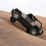
We got back to the main trail and headed off, and then Gary found out that he couldn't get his Jeep out of low range. We pulled to the side of the trail and Gary messed with his transmission as much as he could, but he seemed to be stuck with no high range. We hadn't even had lunch yet on the first day and Gary was out for the rest of the week without a Jeep. He turned around and made his slow way back to town while the rest of us continued on. Gary rode along with someone most of the rest of the week, but it wasn't as nice as it would have been if he could have had his Jeep along. Bummer!

The trail continued to be mellow and we quickly found ourselves climbing up Horse Mountain. The trail was chewed up a bit and you could tell that it had recently been muddy and someone had worked pretty hard to get through it. Some places were still a little damp, but it was pretty much dry and easy for us.

We turned right at the mountain intersection and headed back down. The mountain part almost felt like a tiny trip to Colorado right in the middle of a Utah trail. Weird! It would have been a really nice break from the usual heat if it had been a hot day, but we were having nice temperatures.

Our first sight seeing spur was to the cliff dwellings after getting into Beef Basin. There were cows and cowboys all over the place, so we had managed to drive into a cattle run. We passed them and took the trail for a little way, enjoying some rocky sections and some washed out sections, but we never saw the cliff dwellings. Admittedly, we never got out of our vehicles to go look, but we felt like we still had a long day ahead of us so we didn't take the time.

We had a nice lunch under some cottonwood trees in a sandy wash. There isn't much better than lunch on a Moab trail, and we all enjoyed ourselves.

We did the big loop in Beef Basin and stopped to see the hillside ruin on the far end. It was nice climbing around without too much heat.

We thought it would take longer, but it wasn't long at all before we were at the Tower Ruin. Wow, that site is awesome! The tower still stands pretty tall on one side, and it is still pretty straight. It has seen so much weather and so many people, but it still stands. We took a break in the shade and talked about it for a bit, but then we were off.

The Farmhouse Ruin was much bigger than the Tower Ruin but not that tall in any one spot. It was pretty cool to check out, and we all took lots of pictures.

Even with all of our dawdling we had made it to the end with lots of time left in the day. We all had about a half of a tank of gas, so we pushed on to do the Devil's Lane trail and come out at the trailhead to Elephant Hill. Beef Basin was a great way to start our vacation.

airing_down_part_1
airing_down_part_2
arch_seen_from_cathedral_point
beef_basin_sign_1
beef_basin_sign_2
beef_basin
big_view
canyon_view
cathedral_butte
cathedral_point_trail
climbing
cool_formation
crossroads
early_trail
farmhouse_ruin_part_1
farmhouse_ruin_part_2
farmhouse_ruin_part_3
farmhouse_ruin_part_4
farmhouse_ruin_part_5
farmhouse_ruin_part_6
farmhouse_ruin_sign
following_a_butte
hilltop_ruin
intersection_in_the_mountains
jeeps_to_the_cliff_dwelling
jeffrey_at_cathedral_point
la_sal_mountains
long_and_straight
matt_at_cathedral_point
matt_at_the_farmhouse_ruin
mellow_trail
mike_and_walt
mountain_peak
mountain_sign_1
mountain_signs_2
nearby_rock
parked_at_cathedral_point
parked_at_the_tower_ruin
salt_creek_canyon_sign
sandy
scenery
shelf_road_part_1
shelf_road_part_2
shelf_road_part_3
to_cathedral_point
tom_at_the_farmhouse_ruin
tower_ruin_part_1
tower_ruin_part_2
tower_ruin_part_3
tower_ruin_part_4
trail_on_the_edge
trailhead_sign_1
trailhead_sign_2
up_into_the_mountains
view_from_cathedral_point_part_1
view_from_cathedral_point_part_2
view_from_cathedral_point_part_3
view_from_cathedral_point_part_4
walking_back_from_the_farmhouse_ruin
water_crossing
Join Us!
If you aren’t a Member or Subscriber, you can’t see all of the content on this site. Get membership information to see why this site is best when you join and log in

Information for Subscribers

When you log in you’ll see more information here:

  • Recent Community Forum posts
  • Recent polls
  • Upcoming Events you can attend
  • Links to online users

© 2000-2022 · TrailDamage.com · Terms and Conditions · About · Contact
Trail information is only accurate on the date posted. Trails may have changed or closed since that date. Use this information for historical purposes only.
Contact the Forest Service or Bureau of Land Management for up-to-date trail information.

/* ----------------------------------------- */ /* View slug: reports-other-reports-for-same-trail-slider - start */ /* ----------------------------------------- */ /* place the prev/next controls on the sides */ .td-transition-controls .wpv-filter-next-link, .td-transition-controls .wpv-filter-previous-link { border: none; font-size: 300%; position: absolute; top: 70px; } .td-transition-controls .wpv-filter-previous-link { left: 0; } .td-transition-controls .wpv-filter-next-link { right: 0; } /* center the page selector horizonatally */ .td-transition-controls ul.wpv_pagination_dots { text-align: center; margin-top: 10px; } /* center the page selector horizonatally */ .td-transition-controls ul.wpv_pagination_dots li.wpv_pagination_dots_item, .td-transition-controls .wpv_pagination_dots li a { display: inline-block; float: none; } /* remove the default styles */ .td-transition-controls .wpv_pagination_dots li a { text-decoration: none; border-bottom: none; } .td-slider-container { padding: 0 25px; margin-bottom: 20px; position: relative; width:100%; display:table; } .td-slides { position: relative; } .td-slides-image { float:left; display:table-cell; } .td-slides-image img { border:1px solid #c0c0c0; } .td-slides-content { padding:4px 4px 4px 10px; border-top:1px solid #c0c0c0; border-right:1px solid #c0c0c0; border-bottom:1px solid #c0c0c0; display:table-cell; height:227px; overflow:hidden; } .td-slides-content h3 { margin-top:8px; } .td-slides-leader { font-size:smaller; margin-top:4px; } /* ----------------------------------------- */ /* View slug: reports-other-reports-for-same-trail-slider - end */ /* ----------------------------------------- */
/* ----------------------------------------- */ /* Content Template: Template for a Single Report - start */ /* ----------------------------------------- */ .entry-header { display:none; } .entry-content h1 { margin-top:16px; padding-top:0; } h1 a { color:#222; } h1 a:hover { color:#666; } p.entry-meta { font-size:small; } #report-body-spacer { clear:both; width:100%; height:20px; } #addtoany-bar { margin-bottom:2em; text-align:center; } .category-reports .post-info .author, .post-info .date { display: none; } .addthis_recommended_horizontal { text-align:center !important; } /* ----------------------------------------- */ /* Content Template: Template for a Single Report - end */ /* ----------------------------------------- */ /* ----------------------------------------- */ /* Content Template: Loop item in REPORTS Runners - start */ /* ----------------------------------------- */ #runners-container { width:100%; clear:both; } .runner { border:1px solid #c0c0c0; margin:0 6px 6px 0; float:left; width:49%; height:81px; } .runner-image { float: left; } .runner-image img { margin:2px 10px 0 2px; height:75px; width:75px; } .runner-name { text-transform:uppercase; } .runner-name a { color:#222; } .runner-name a:hover { color:#666; } .runner-vehicle { font-size:small; } @media only screen and (max-width: 768px) { .runner { width:100%; } } /* ----------------------------------------- */ /* Content Template: Loop item in REPORTS Runners - end */ /* ----------------------------------------- */