TrailDamage.com

Photos, videos and information about 4x4 trails in Colorado and Utah

  • Trails
    • Colorado
    • Utah
  • Reports
    • Featured Photos
    • Featured Videos
    • Reports Calendar
  • Members
  • Search
  • Trail Damage Winners
  • FAQ
  • Community
  • Upcoming Events
  • Membership
  • Log In
  • Facebook
  • Instagram
  • RSS
  • Twitter
  • YouTube

Bangs Canyon 040905

September 5, 2004 by Monica

Bangs Canyon

Trail Run on September 5, 2004
Report and photos by Monica I., Trail Leader
View trail information for Bangs Canyon

Monica I.
Red 2010 Jeep Wrangler Rubicon
Bob R.
Green 2003 Jeep Wrangler Rubicon
Robert M.
Green 1987 Jeep Wrangler
John K.
Black 1990 Jeep Cherokee

After a rainy day the day before we were treated to sunshine all day as we played on the trail. We had a blast at the playground but we only made it a little way into the clay until it was too slick to continue. It was a great 3.5 miles, though!

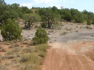
We aired down and got on the trail, expecting lots of people there for Labor Day Weekend. We ended up only seeing one other truck on the trail and we made the first tracks in the mud. The start of the trail was filled with mud puddles in the deep ruts in the sandy dirt, and we watched the clouds roll out to be replaced with blue skies.

The views were incredible and looked so much like Moab it was amazing. A lot of it looked like the small trees on Porcupine Rim. There were also the big slabs of rock that you see out there, and the trail was marked with white rectangles painted on the rock, making it really easy to find.

We took the "difficult" route at the fork, putting us on the stairs. There was one set that had pretty tall stairs, but we all got down them without any trouble. Then we were in the playground.

Robert was the only one to try the big obstacle, and he made it up and down it multiple times, in addition to the big stairs next to it. It was great to watch him, and he didn't get any trail damage.

Monica, Bob and John all played up and down the other slopes of slickrock. There was a little scraping on the way down the steep one (and it's pretty steep!) but no damage.

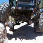
Robert's power steering was making a lot of noise so he checked it out, only to find his fluid was almost gone. He decided to run back to town to get more, then come back to catch up with the rest of the group.

We continued on, following the sign that said "trail" after the rock hill, pointing to the right. This took us to a sandy area that was flat and large. We got out to check it out and there was a hiking trail there that went down to the canyon floor. The sign said hikers and motorcycles were permitted, but upon closer
inspection you could tell that someone had peeled off the red line through the motorcycle icon. Only hikers were permitted on that trail.

We continued on in the sand and soon found ourselves climbing up a rocky trail. There were a few bigger rocks to either drive over or around, and we all picked fun lines. Then the sand started to turn to mud.

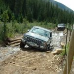
We got to one obstacle where there was a big rock at the top (too big to straddle for us). It was really hard to get around and impossible to get over because the mud was starting to mix with clay and it was extremely slick. John went last and had it worst because Bob and Monica had really made it slippery.

We all made it past the rock and kept climbing. Finally we made it to the true clay and it was very wet. The clay on the sides was still shiny with water, though it hadn't rained since the night before. It was slick and Monica had some issues but we finally got to the bottom of the switchbacks.

Monica tried to go up the first clay switchback but it wasn't going to happen. From the place where she was stuck she could see the other switchbacks and it looked way too dangerous on slick clay.

Bob gave it a try but it wasn't going to happen for him either. That's when Robert caught up to us again. We decided this was a good place for lunch so we took a break before heading back down.

When we got back to the playground we all played on the biggest stairs on the trail. With the sand on them they were pretty challenging and fun. We made it back to the trailhead without any issues.

This trail is a blast and we hope to see the rest of it on a day that isn't so sloppy.

airing_down
as_far_as_we_got
big_view
blue_skies_appearing
bob_and_john
bob_and_monica
bob_climbing_a_hill
bob_climbing_down_part_1
bob_climbing_down_part_2
bob_climbing_up
bob_down_stairs
bob_on_clay
bob_on_sand
bob_on_the_edge
bob_on_the_trail
bob_shoe_bumper
clarks_bench
clay
climbing_rocks
climbing_wet_clay
coming_down
cross_canyon
fall_colors
flat_trail
follow_markers
grand_junction
horse_mesa
john_and_monica
john_climbing_a_hill
john_climbing_down_part_1
john_climbing_down_part_2
john_climbing_up_part_1
john_climbing_up_part_2
john_climbing_up_part_3
john_climbing_up_part_4
john_down_stairs
john_on_clay
john_on_the_edge
john_on_the_trail
john_on_wet_clay_part_1
john_on_wet_clay_part_2
john_on_wet_clay_part_3
john_slipping_part_1
john_slipping_part_2
john_slipping_part_3
john_up_the_stairs
lone_clouds
monica_climbing_down_part_1
monica_climbing_down_part_2
monica_climbing_down_part_3
monica_climbing_down_part_4
monica_muddy
monica_on_clay
monica_on_the_trail
on_the_sand
packed_tire
robert_at_the_top
robert_checking_power_steering
robert_climbing_down
robert_down_stairs
robert_flexing
robert_in_the_rocks_part_1
robert_in_the_rocks_part_2
robert_in_the_rocks_part_3
robert_in_the_rocks_part_4
robert_in_the_rocks_part_5
robert_on_stairs
robert_on_the_trail
robert_up_the_stairs
rocky_trail
rough_canyon
sandy_trail
scenery
shoe
short_trees
sign_number_1
sign_number_2
sign_number_3
sign_number_4
sign_number_5
sign_number_6
sign_number_7
slab_of_rock
slickrock
slippery_clay
stairs
start_of_the_clay
start_of_the_trail
stay_on_route
the_rocks_part_1
the_rocks_part_2
thick_clay_mud
trail_downhill
trail_on_the_edge
trees

Report from a Different Day

August 26, 2007

Led by Monica I.
Robert and Ladd headed for home and Don and Monica headed off to run Bangs Canyon before going back to Denver. It was a gorgeous day as we aired down at the staging area and started in along the trail. We had run Bangs Canyon in 2004 but we were…
Join Us!
If you aren’t a Member or Subscriber, you can’t see all of the content on this site. Get membership information to see why this site is best when you join and log in

Information for Subscribers

When you log in you’ll see more information here:

  • Recent Community Forum posts
  • Recent polls
  • Upcoming Events you can attend
  • Links to online users

© 2000-2022 · TrailDamage.com · Terms and Conditions · About · Contact
Trail information is only accurate on the date posted. Trails may have changed or closed since that date. Use this information for historical purposes only.
Contact the Forest Service or Bureau of Land Management for up-to-date trail information.

/* ----------------------------------------- */ /* View slug: reports-other-reports-for-same-trail-slider - start */ /* ----------------------------------------- */ /* place the prev/next controls on the sides */ .td-transition-controls .wpv-filter-next-link, .td-transition-controls .wpv-filter-previous-link { border: none; font-size: 300%; position: absolute; top: 70px; } .td-transition-controls .wpv-filter-previous-link { left: 0; } .td-transition-controls .wpv-filter-next-link { right: 0; } /* center the page selector horizonatally */ .td-transition-controls ul.wpv_pagination_dots { text-align: center; margin-top: 10px; } /* center the page selector horizonatally */ .td-transition-controls ul.wpv_pagination_dots li.wpv_pagination_dots_item, .td-transition-controls .wpv_pagination_dots li a { display: inline-block; float: none; } /* remove the default styles */ .td-transition-controls .wpv_pagination_dots li a { text-decoration: none; border-bottom: none; } .td-slider-container { padding: 0 25px; margin-bottom: 20px; position: relative; width:100%; display:table; } .td-slides { position: relative; } .td-slides-image { float:left; display:table-cell; } .td-slides-image img { border:1px solid #c0c0c0; } .td-slides-content { padding:4px 4px 4px 10px; border-top:1px solid #c0c0c0; border-right:1px solid #c0c0c0; border-bottom:1px solid #c0c0c0; display:table-cell; height:227px; overflow:hidden; } .td-slides-content h3 { margin-top:8px; } .td-slides-leader { font-size:smaller; margin-top:4px; } /* ----------------------------------------- */ /* View slug: reports-other-reports-for-same-trail-slider - end */ /* ----------------------------------------- */
/* ----------------------------------------- */ /* Content Template: Template for a Single Report - start */ /* ----------------------------------------- */ .entry-header { display:none; } .entry-content h1 { margin-top:16px; padding-top:0; } h1 a { color:#222; } h1 a:hover { color:#666; } p.entry-meta { font-size:small; } #report-body-spacer { clear:both; width:100%; height:20px; } #addtoany-bar { margin-bottom:2em; text-align:center; } .category-reports .post-info .author, .post-info .date { display: none; } .addthis_recommended_horizontal { text-align:center !important; } /* ----------------------------------------- */ /* Content Template: Template for a Single Report - end */ /* ----------------------------------------- */ /* ----------------------------------------- */ /* Content Template: Loop item in REPORTS Runners - start */ /* ----------------------------------------- */ #runners-container { width:100%; clear:both; } .runner { border:1px solid #c0c0c0; margin:0 6px 6px 0; float:left; width:49%; height:81px; } .runner-image { float: left; } .runner-image img { margin:2px 10px 0 2px; height:75px; width:75px; } .runner-name { text-transform:uppercase; } .runner-name a { color:#222; } .runner-name a:hover { color:#666; } .runner-vehicle { font-size:small; } @media only screen and (max-width: 768px) { .runner { width:100%; } } /* ----------------------------------------- */ /* Content Template: Loop item in REPORTS Runners - end */ /* ----------------------------------------- */