TrailDamage.com

Photos, videos and information about 4x4 trails in Colorado and Utah

  • Trails
    • Colorado
    • Utah
  • Reports
    • Featured Photos
    • Featured Videos
    • Reports Calendar
  • Members
  • Search
  • Trail Damage Winners
  • FAQ
  • Community
  • Upcoming Events
  • Membership
  • Log In
  • Facebook
  • Instagram
  • RSS
  • Twitter
  • YouTube

Withers Canyon 130615

June 15, 2013 by Monica

Withers Canyon

Trail Run on June 15, 2013
Report and photos by Monica I., Trail Leader
View trail information for Withers Canyon

Monica I.
Red 2010 Jeep Wrangler Rubicon
Ben P.
Green 2012 Jeep Wrangler Unlimited Rubicon
Walt S.
Gray 2018 Jeep Wrangler Unlimited Rubicon

We came off of the Picketwire Canyon tour with many hours of sunshine left in the day. The tour guide had told us about Withers Canyon, a great way to see Picketwire Canyon from above. He gave us verbal directions and we headed off to find the trail. It turned out the directions weren't entirely accurate.

We passed by the trailhead by a few miles and then stopped to consult a map as we knew we were far from Picketwire Canyon. At that point, Bob told us he was going to head into town so the three of us turned around to go back to an area we suspected was where the trailhead was hidden. We found it, along with a broken and closed pit toilet.

We found ourselves at the campground first. The trip down into Withers Canyon was a hiking trail so we continued on. When we got back to the loop we found some people at the intersection who had been on our tour. They said they also followed some poor directions but managed to find their way to the overlook. We were happy to hear we weren't the only lost ones.

We headed to the end of the trail at the locked gate and decided to walk the rest of the way. It was overcast and it looked like the rain was on its way, but we decided to chance it. The walk was easy and nice, and the views at the end were cool. We could see a cabin down in the valley and the 4x4 trail below us.

The walk back was in the sun and we were all sunburned and tired. Still, when we got back to the vehicles we stopped at the other overlooks on the way back to the intersection. We hadn't seen the Spanish mission on the tour because of mud, so it was good to see it from above.

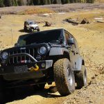
The rest of the loop would have been really mellow but we had fun because it was really muddy in spots. Ben had fun getting his Jeep very, very muddy. It meant we were smiling when we made it back to the trailhead.

We headed back into town and met Bob for dinner at a weird Mexican restaurant. Bob was heading home in the morning but the rest of us would go explore other canyons in the area. We had a really good time in the ones we'd found so far.

ben_on_the_trail
big_sky
cabin_below
cactus_bloom
cactus_flowers
campground_pit_toilet
canyon_curves
carsonite_sign
cattle_guard
cloud-making_machine
clouds
country_road
coyote
dirt_track
early_bumps
fish_eye_weather
hanging_out
intersection_panorama
intersection_view_part_1
intersection_view_part_2
kiosk_map
locked_gate
monica_and_ben
monica_on_the_trail
not-so-distant_rain
on_the_trail
on_the_way_out
overlook_3_panorama
parked_at_the_intersection
picketwire_canyon
picketwire_corrals
pronghorn
puddle
purgatoire_river
right_turn
sign_near_the_trailhead
small_trees
spanish_mission
start_of_the_trail
storm_clouds
trail_sign
trailhead_sign
trailhead
view_from_overlook_3_part_1
view_from_overlook_3_part_2
view_from_overlook_3_part_3
view_from_overlook_3_part_4
view_from_overlook_3_part_5
walk_to_overlook_3
walt_on_the_trail
withers_canyon_campground
Join Us!
If you aren’t a Member or Subscriber, you can’t see all of the content on this site. Get membership information to see why this site is best when you join and log in

Information for Subscribers

When you log in you’ll see more information here:

  • Recent Community Forum posts
  • Recent polls
  • Upcoming Events you can attend
  • Links to online users

© 2000-2021 · TrailDamage.com · Terms and Conditions · About · Contact
Trail information is only accurate on the date posted. Trails may have changed or closed since that date. Use this information for historical purposes only.
Contact the Forest Service or Bureau of Land Management for up-to-date trail information.

/* ----------------------------------------- */ /* View slug: reports-other-reports-for-same-trail-slider - start */ /* ----------------------------------------- */ /* place the prev/next controls on the sides */ .td-transition-controls .wpv-filter-next-link, .td-transition-controls .wpv-filter-previous-link { border: none; font-size: 300%; position: absolute; top: 70px; } .td-transition-controls .wpv-filter-previous-link { left: 0; } .td-transition-controls .wpv-filter-next-link { right: 0; } /* center the page selector horizonatally */ .td-transition-controls ul.wpv_pagination_dots { text-align: center; margin-top: 10px; } /* center the page selector horizonatally */ .td-transition-controls ul.wpv_pagination_dots li.wpv_pagination_dots_item, .td-transition-controls .wpv_pagination_dots li a { display: inline-block; float: none; } /* remove the default styles */ .td-transition-controls .wpv_pagination_dots li a { text-decoration: none; border-bottom: none; } .td-slider-container { padding: 0 25px; margin-bottom: 20px; position: relative; width:100%; display:table; } .td-slides { position: relative; } .td-slides-image { float:left; display:table-cell; } .td-slides-image img { border:1px solid #c0c0c0; } .td-slides-content { padding:4px 4px 4px 10px; border-top:1px solid #c0c0c0; border-right:1px solid #c0c0c0; border-bottom:1px solid #c0c0c0; display:table-cell; height:227px; overflow:hidden; } .td-slides-content h3 { margin-top:8px; } .td-slides-leader { font-size:smaller; margin-top:4px; } /* ----------------------------------------- */ /* View slug: reports-other-reports-for-same-trail-slider - end */ /* ----------------------------------------- */
/* ----------------------------------------- */ /* Content Template: Template for a Single Report - start */ /* ----------------------------------------- */ .entry-header { display:none; } .entry-content h1 { margin-top:16px; padding-top:0; } h1 a { color:#222; } h1 a:hover { color:#666; } p.entry-meta { font-size:small; } #report-body-spacer { clear:both; width:100%; height:20px; } #addtoany-bar { margin-bottom:2em; text-align:center; } .category-reports .post-info .author, .post-info .date { display: none; } .addthis_recommended_horizontal { text-align:center !important; } /* ----------------------------------------- */ /* Content Template: Template for a Single Report - end */ /* ----------------------------------------- */ /* ----------------------------------------- */ /* Content Template: Loop item in REPORTS Runners - start */ /* ----------------------------------------- */ #runners-container { width:100%; clear:both; } .runner { border:1px solid #c0c0c0; margin:0 6px 6px 0; float:left; width:49%; height:81px; } .runner-image { float: left; } .runner-image img { margin:2px 10px 0 2px; height:75px; width:75px; } .runner-name { text-transform:uppercase; } .runner-name a { color:#222; } .runner-name a:hover { color:#666; } .runner-vehicle { font-size:small; } @media only screen and (max-width: 768px) { .runner { width:100%; } } /* ----------------------------------------- */ /* Content Template: Loop item in REPORTS Runners - end */ /* ----------------------------------------- */