TrailDamage.com

Photos, videos and information about 4x4 trails in Colorado and Utah

  • Trails
    • Colorado
    • Utah
  • Reports
    • Featured Photos
    • Featured Videos
    • Reports Calendar
  • Members
  • Search
  • Trail Damage Winners
  • FAQ
  • Community
  • Upcoming Events
  • Membership
  • Log In
  • Facebook
  • Instagram
  • RSS
  • Twitter
  • YouTube

Tower Arch 121019

October 19, 2012 by Monica

Tower Arch

Trail Run on October 19, 2012
Report and photos by Monica I., Trail Leader
View trail information for Tower Arch

Ben P.
Green 2012 Jeep Wrangler Unlimited Rubicon
Roger R.
Gray 2021 Jeep Wrangler Rubicon 4xe
Bill S.
Yellow 2020 Jeep Wrangler Rubicon
Monica I.
Red 2010 Jeep Wrangler Rubicon

Tower Arch was one of the first trails we did as a group in Moab a decade ago, so it was nice to visit it again. We found it in the middle of the trail when we finished the Eye of the Whale trail, which was handy. We headed southwest on the mellow sand.

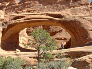
The trail was nothing compared to the Cache Valley trail we'd done earlier, but it had its fun spots. It was a really nice drive, and the scenery was really great. We soon found our way at the end of the trail in the big parking area next to the arch. Monica had done the hike before so she hung back to take pictures of the hikers as they worked their way to the arch.

It's funny how small the arch looks when you first see it, because it's actually pretty big when you're under it. Everyone walked around exploring the area and finding Parallel Arch next to it. The weather and the scenery were both perfect, and everyone just relaxed.

When the hikers got back we all sat on a big rock talking and being mellow. It was our first day in Moab this trip and no one ever wants to go back to town. Still, Walt was waiting in town so we headed back in. We had considered mapping out the entirety of Salt Valley Road, but when we got to it at the Tower Arch trailhead we just decided to head back.

We got to the Balanced Rock parking area at sunset, so we stopped with a lot of other people to snap some pictures. It was a really nice sunset, and we left in a big mob. That meant we were in a long line of cars on the way out, which was kind of cool.

When we got back to town we found Walt all fixed and ready to go. We had dinner at our favorite Mexican restaurant and headed back to our wonderful stay at the Adventure Inn. It was an incredible day!

approaching_the_arch
awesome_view
balanced_rock_part_2
balanced_rock
ben_and_roger_hiking
ben_on_the_trail
big_sky
bill_on_the_trail
chunks
cool_rock_formations
crazy_views
curve
fins_near_the_arch
four-wheel_drive
hike_to_the_arch_part_1
hike_to_the_arch_part_2
hoodoos
little_fins
long_and_sandy
marching_men
moab_colors
nick_hiking
parallel_arch_part_2
parallel_arch
red_dirt
roger_and_ben_at_the_arch
salt_valley_road
shadows
sign_to_eye_of_the_whale
skyline_arch_part_1
skyline_arch_part_2
slickrock_trail
through_brush
tower_and_arch
tower_arch
trailhead_sign
under_the_arch
view_from_the_arch_parking
y_m_c_a!

Reports from Other Days: 2

Use the arrows or dots to flip through the previews of the other reports for Tower Arch. Click one of them to read more and see all of the photos from that day.

October 17, 2002

Led by Monica I.
We ran this one to check out an arch — we had been to Moab before but hadn’t done any trails with arches. We also hadn’t seen Arches National Park before so that was cool too. The dirt road isn’t that fun. It’s all washboard and really bumpy for what…
«
  • 1
  • 2
Join Us!
If you aren’t a Member or Subscriber, you can’t see all of the content on this site. Get membership information to see why this site is best when you join and log in

Information for Subscribers

When you log in you’ll see more information here:

  • Recent Community Forum posts
  • Recent polls
  • Upcoming Events you can attend
  • Links to online users

© 2000-2023 · TrailDamage.com · Terms and Conditions · About · Contact
Trail information is only accurate on the date posted. Trails may have changed or closed since that date. Use this information for historical purposes only.
Contact the Forest Service or Bureau of Land Management for up-to-date trail information.

/* ----------------------------------------- */ /* View slug: reports-other-reports-for-same-trail-slider - start */ /* ----------------------------------------- */ /* place the prev/next controls on the sides */ .td-transition-controls .wpv-filter-next-link, .td-transition-controls .wpv-filter-previous-link { border: none; font-size: 300%; position: absolute; top: 70px; } .td-transition-controls .wpv-filter-previous-link { left: 0; } .td-transition-controls .wpv-filter-next-link { right: 0; } /* center the page selector horizonatally */ .td-transition-controls ul.wpv_pagination_dots { text-align: center; margin-top: 10px; } /* center the page selector horizonatally */ .td-transition-controls ul.wpv_pagination_dots li.wpv_pagination_dots_item, .td-transition-controls .wpv_pagination_dots li a { display: inline-block; float: none; } /* remove the default styles */ .td-transition-controls .wpv_pagination_dots li a { text-decoration: none; border-bottom: none; } .td-slider-container { padding: 0 25px; margin-bottom: 20px; position: relative; width:100%; display:table; } .td-slides { position: relative; } .td-slides-image { float:left; display:table-cell; } .td-slides-image img { border:1px solid #c0c0c0; } .td-slides-content { padding:4px 4px 4px 10px; border-top:1px solid #c0c0c0; border-right:1px solid #c0c0c0; border-bottom:1px solid #c0c0c0; display:table-cell; height:227px; overflow:hidden; } .td-slides-content h3 { margin-top:8px; } .td-slides-leader { font-size:smaller; margin-top:4px; } /* ----------------------------------------- */ /* View slug: reports-other-reports-for-same-trail-slider - end */ /* ----------------------------------------- */
/* ----------------------------------------- */ /* Content Template: Template for a Single Report - start */ /* ----------------------------------------- */ .entry-header { display:none; } .entry-content h1 { margin-top:16px; padding-top:0; } h1 a { color:#222; } h1 a:hover { color:#666; } p.entry-meta { font-size:small; } #report-body-spacer { clear:both; width:100%; height:20px; } #addtoany-bar { margin-bottom:2em; text-align:center; } .category-reports .post-info .author, .post-info .date { display: none; } .addthis_recommended_horizontal { text-align:center !important; } /* ----------------------------------------- */ /* Content Template: Template for a Single Report - end */ /* ----------------------------------------- */ /* ----------------------------------------- */ /* Content Template: Loop item in REPORTS Runners - start */ /* ----------------------------------------- */ #runners-container { width:100%; clear:both; } .runner { border:1px solid #c0c0c0; margin:0 6px 6px 0; float:left; width:49%; height:81px; } .runner-image { float: left; } .runner-image img { margin:2px 10px 0 2px; height:75px; width:75px; } .runner-name { text-transform:uppercase; } .runner-name a { color:#222; } .runner-name a:hover { color:#666; } .runner-vehicle { font-size:small; } @media only screen and (max-width: 768px) { .runner { width:100%; } } /* ----------------------------------------- */ /* Content Template: Loop item in REPORTS Runners - end */ /* ----------------------------------------- */