TrailDamage.com

Photos, videos and information about 4x4 trails in Colorado and Utah

  • Trails
    • Colorado
    • Utah
  • Reports
    • Featured Photos
    • Featured Videos
    • Reports Calendar
  • Members
  • Search
  • Trail Damage Winners
  • FAQ
  • Community
  • Upcoming Events
  • Membership
  • Log In
  • Facebook
  • Instagram
  • RSS
  • Twitter
  • YouTube

Slaughterhouse Gulch 100710

July 10, 2010 by Monica

Slaughterhouse Gulch

Trail Run on July 10, 2010
Report and photos by Monica I., Trail Leader
View trail information for Slaughterhouse Gulch

Monica I.
Red 2010 Jeep Wrangler Rubicon
Matt K.
White 2016 Jeep Wrangler Unlimited Rubicon
Mark F.
Blue 2002 Jeep Wrangler
Bryan P.
Teal 1993 Jeep Wrangler
Walt S.
Gray 2018 Jeep Wrangler Unlimited Rubicon

Back in the day, we used to run Slaughterhouse Gulch at least once a year. It was one of our favorite trails, and we always had a good time there. Over the last few years, though, it seems to have been replaced by other trails for us. This year, however, we were going to enjoy it again like we used to.

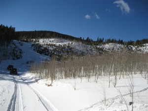
We only had five vehicles on the trail, which was nice. It was a sunny day and it promised to be a good one on the trail. We aired down at the trailhead and we were soon on our way. We saw a couple people camping but otherwise the trail was pretty empty.

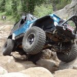
When we got to Poser Rock, only a few people got on it. Matt felt his rear tire getting light, and he stopped there for poser pictures. Bryan got some good flex on it, too. Walt gave it a good try but his bumper wouldn't let him really get up on the rock unless he gunned it, and he decided that wasn't a good idea.

We stopped for a little break in the open area just before heading down the hill, but then it was time to descend. It sure is easier when it isn't covered in snow and ice. No one had any issues and we were soon down at the bottom.

It was very green, with lots of trees surrounding the trail. There were also lots of wild flowers on both sides. There wasn't much mud, and the mud hole that once gave us some trouble as well as some fun was dried up and filled in with logs.

It didn't take us long at all to get to the bottom of the hill that takes you back up to the top. We had heard that the whoopdeedoos were filled in, so we were very happy to find out that the rumors weren't true. The trail was as fun as it always had been in the past.

We didn't remember so many options to climb the base of the hill, however. We all took different lines, too. Monica went up the old way on the left, Mark went up the middle, and the other people went up the right side. They were all fun in their own way, though it seemed like the left line was steeper and the right light was looser with more rocks. The middle line was definitely the easiest way up.

The whoopdeedoo section has changed here and there but it was still quite a bit of fun. Almost everyone went through it, testing their suspensions along the way. Bryan had his mom along in the passenger seat, and they both looked like they had a blast.

We kept going up the hill, enjoying its challenges. When we came to flat spot that had parking, we stopped for lunch. It was a good time sitting and chatting, as always.

The gate was up by the mud pits, closing that area off as well as blocking the way to the Crow Creek trail. We had hoped to take that way out to the highway as an alternate exit, but it wasn't meant to be. So we headed out the usual way.

We finally stopped at the gas station near the highway, and it was just as busy as ever. Bryan and Mark headed for home while Monica, Matt and Walt all continued on with their adventures. It was still very early in the afternoon and the day held more promises.

airing_down
aspen_trees
big_view
blue_jeeps
bryan_climbing
bryan_in_whoopdeedoos_part_1
bryan_in_whoopdeedoos_part_2
bryan_in_whoopdeedoos_part_3
bryan_in_whoopdeedoos_part_4
bryan_in_whoopdeedoos_part_5
bryan_in_whoopdeedoos_part_6
bryan_in_whoopdeedoos_part_7
bryan_in_whoopdeedoos_part_8
bryan_on_poser_rock_part_1
bryan_on_poser_rock_part_2
bryan_on_poser_rock_part_3
bryan_on_the_trail
bryan_parked
bryan_up_the_hill_part_1
bryan_up_the_hill_part_2
bryan_up_the_hill_part_3
bumpy
campsite
crossroads
down_the_big_hill
green
hillside
into_a_clearing
into_the_trees
little_mud
lunch_part_1
lunch_part_2
mark_climbing
mark_on_the_trail
mark_up_the_hill_part_1
mark_up_the_hill_part_2
matt_in_whoopdeedoos_part_1
matt_in_whoopdeedoos_part_2
matt_in_whoopdeedoos_part_3
matt_in_whoopdeedoos_part_4
matt_in_whoopdeedoos_part_5
matt_on_poser_rock_part_1
matt_on_poser_rock_part_2
matt_on_poser_rock_part_3
matt_on_the_trail
matt_parked
matt_up_the_hill_part_1
matt_up_the_hill_part_2
matt_up_the_hill_part_3
mellow_trail
monica_airing_down
monica_in_whoopdeedoos_part_1
monica_in_whoopdeedoos_part_2
monica_in_whoopdeedoos_part_3
monica_in_whoopdeedoos_part_4
monica_on_the_trail
monica_parked
monica_up_the_hill_part_1
monica_up_the_hill_part_2
monica_up_the_hill_part_3
monica_up_the_hill_part_4
mud_pits_closed
mud_pits_gate
old_mud_hole
old_stump_hill
parked_at_the_bottom
scenery
start_of_the_trail
sunny_skies
trail_across_the_way
trees_close_by
walt_down_a_hill
walt_in_scenery
walt_in_whoopdeedoos_part_1
walt_in_whoopdeedoos_part_2
walt_in_whoopdeedoos_part_3
walt_in_whoopdeedoos_part_4
walt_on_poser_rock
walt_on_the_trail
walt_parked
walt_playing
walt_up_the_hill_part_1
walt_up_the_hill_part_2
walt_up_the_hill_part_3

Reports from Other Days: 15

Use the arrows or dots to flip through the previews of the other reports for Slaughterhouse Gulch. Click one of them to read more and see all of the photos from that day.

January 12, 2008

Led by Mike S.
Slaughterhouse Gulch has been a great trail for late fall runs or early spring runs, always with a good chance that there might be some snow. The trail is usually passable, though. This time we were trying the trail in mid-January looking for more of a challenge, and we found…
« »
  • 1
  • 2
  • 3
  • 4
  • 5
  • 6
  • 7
  • 8
  • 9
  • 10
  • 11
  • 12
  • 13
  • 14
  • 15
Join Us!
If you aren’t a Member or Subscriber, you can’t see all of the content on this site. Get membership information to see why this site is best when you join and log in

Information for Subscribers

When you log in you’ll see more information here:

  • Recent Community Forum posts
  • Recent polls
  • Upcoming Events you can attend
  • Links to online users

© 2000-2022 · TrailDamage.com · Terms and Conditions · About · Contact
Trail information is only accurate on the date posted. Trails may have changed or closed since that date. Use this information for historical purposes only.
Contact the Forest Service or Bureau of Land Management for up-to-date trail information.

/* ----------------------------------------- */ /* View slug: reports-other-reports-for-same-trail-slider - start */ /* ----------------------------------------- */ /* place the prev/next controls on the sides */ .td-transition-controls .wpv-filter-next-link, .td-transition-controls .wpv-filter-previous-link { border: none; font-size: 300%; position: absolute; top: 70px; } .td-transition-controls .wpv-filter-previous-link { left: 0; } .td-transition-controls .wpv-filter-next-link { right: 0; } /* center the page selector horizonatally */ .td-transition-controls ul.wpv_pagination_dots { text-align: center; margin-top: 10px; } /* center the page selector horizonatally */ .td-transition-controls ul.wpv_pagination_dots li.wpv_pagination_dots_item, .td-transition-controls .wpv_pagination_dots li a { display: inline-block; float: none; } /* remove the default styles */ .td-transition-controls .wpv_pagination_dots li a { text-decoration: none; border-bottom: none; } .td-slider-container { padding: 0 25px; margin-bottom: 20px; position: relative; width:100%; display:table; } .td-slides { position: relative; } .td-slides-image { float:left; display:table-cell; } .td-slides-image img { border:1px solid #c0c0c0; } .td-slides-content { padding:4px 4px 4px 10px; border-top:1px solid #c0c0c0; border-right:1px solid #c0c0c0; border-bottom:1px solid #c0c0c0; display:table-cell; height:227px; overflow:hidden; } .td-slides-content h3 { margin-top:8px; } .td-slides-leader { font-size:smaller; margin-top:4px; } /* ----------------------------------------- */ /* View slug: reports-other-reports-for-same-trail-slider - end */ /* ----------------------------------------- */
/* ----------------------------------------- */ /* Content Template: Template for a Single Report - start */ /* ----------------------------------------- */ .entry-header { display:none; } .entry-content h1 { margin-top:16px; padding-top:0; } h1 a { color:#222; } h1 a:hover { color:#666; } p.entry-meta { font-size:small; } #report-body-spacer { clear:both; width:100%; height:20px; } #addtoany-bar { margin-bottom:2em; text-align:center; } .category-reports .post-info .author, .post-info .date { display: none; } .addthis_recommended_horizontal { text-align:center !important; } /* ----------------------------------------- */ /* Content Template: Template for a Single Report - end */ /* ----------------------------------------- */ /* ----------------------------------------- */ /* Content Template: Loop item in REPORTS Runners - start */ /* ----------------------------------------- */ #runners-container { width:100%; clear:both; } .runner { border:1px solid #c0c0c0; margin:0 6px 6px 0; float:left; width:49%; height:81px; } .runner-image { float: left; } .runner-image img { margin:2px 10px 0 2px; height:75px; width:75px; } .runner-name { text-transform:uppercase; } .runner-name a { color:#222; } .runner-name a:hover { color:#666; } .runner-vehicle { font-size:small; } @media only screen and (max-width: 768px) { .runner { width:100%; } } /* ----------------------------------------- */ /* Content Template: Loop item in REPORTS Runners - end */ /* ----------------------------------------- */