TrailDamage.com

Photos, videos and information about 4x4 trails in Colorado and Utah

  • Trails
    • Colorado
    • Utah
  • Reports
    • Featured Photos
    • Featured Videos
    • Reports Calendar
  • Members
  • Search
  • Trail Damage Winners
  • FAQ
  • Community
  • Upcoming Events
  • Membership
  • Log In
  • Facebook
  • Instagram
  • RSS
  • Twitter
  • YouTube

Saints John 200801

August 1, 2020 by Monica

Saints John

Trail Run on August 1, 2020
Report and photos by Monica I., Trail Leader
View trail information for Saints John

Matt K.
White 2016 Jeep Wrangler Unlimited Rubicon
Monica I.
Red 2010 Jeep Wrangler Rubicon

Saints John and Deer Creek both leave from Montezuma and head up above timberline, but they do it across a valley from each other.  They're both amazing trails, and this time we did Saints John to get back up to elevation.  Naturally, it was gorgeous.

We saw a few people camping and enjoying the trail all the way to the end.  We went through the little community on the trail, and then we didn't see civilization again for a while.

For the first time, we saw the mountain goats well below timberline.  We usually see them up on Wise Mountain, but this time they were grazing below the switchbacks.  A new Grand Cherokee with paper plates was headed down, and we were impressed.  They were also completely distracted by the goats.

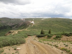
The switchbacks were chunky and fun, but it wasn't long before we were at the top.  The weather there was completely different than it was on our last trail and in Montezuma.  Below timberline, it was sunny and warm with not much of a breeze.  Up on top, it was very windy and probably around 50 degrees.  And the blue skies were starting to cloud over.

We started to see many side-by-sides on the trail.  It would be a good place to be in an OHV, because it is a large network of trails.  We all managed to get around each other on the flat spots between the steep hills.

Almost to the end at the intersection with Swan River, we saw a huge collection of OHVs in the distance, with a smaller group we were catching up to that was parked in the trail.  As we got closer, one did a donut on the short, fragile grass well off of the trail while another drove around on it.  Then they threw a beer can down the side of the mountain and headed off.  It was the only bad behavior we'd seen all day, and it was a shock.  Luckily, we don't see much of that anymore, but it does seem to go with drinking and driving.

They caught up with the rest of their huge group, and we watched them all turn to go down Swan River.  We were headed that way, but we went up to the Wise Mountain cabin instead so we could put a little distance between us and the rowdy group.  We were glad we did, because we found the cabin completely caved in on the inside.  Apparently it fell into a mine shaft.  It is not usable now, and it is dangerous.  It was also odd to not see any mountain goats at the cabin.

When we eventually wandered back down to Swan River we caught up with the group again, and it was raining hard.  We slowly followed them down to their huge camp spot near the end of the trail.  Apparently everyone isn't following the coronavirus guidance.  We still really enjoyed the trip over the mountain.

P1060639
P1060699
P1060700
P1060701
P1060702
P1060703
P1060704
P1060705
P1060706
P1060707
P1060708
P1060709
P1060710
P1060712
P1060713
P1060714
P1060715
P1060716
P1060717
P1060718
P1060719
P1060720
P1060721
P1060722
P1060723
P1060724
P1060725
P1060726
P1060727
P1060728
P1060729
P1060730
P1060731
P1060732
P1060733
P1060734
P1060735
P1060736
P1060737
P1060738
P1060739
P1060740
P1060741
P1060742
P1060743

Reports from Other Days: 2

Use the arrows or dots to flip through the previews of the other reports for Saints John. Click one of them to read more and see all of the photos from that day.

July 26, 2014

Led by Monica I.
We left from the tiny town of Montezuma and headed uphill. We talked for a moment about doing Hunkidori Mine, but we planned on wrestling with S.O.B. Hill later so we skipped it. S.O.B. Hill proved to be too difficult in the rain and mud, so it turned out to…
»
  • 1
  • 2
Join Us!
If you aren’t a Member or Subscriber, you can’t see all of the content on this site. Get membership information to see why this site is best when you join and log in

Information for Subscribers

When you log in you’ll see more information here:

  • Recent Community Forum posts
  • Recent polls
  • Upcoming Events you can attend
  • Links to online users

© 2000-2023 · TrailDamage.com · Terms and Conditions · About · Contact
Trail information is only accurate on the date posted. Trails may have changed or closed since that date. Use this information for historical purposes only.
Contact the Forest Service or Bureau of Land Management for up-to-date trail information.

/* ----------------------------------------- */ /* View slug: reports-other-reports-for-same-trail-slider - start */ /* ----------------------------------------- */ /* place the prev/next controls on the sides */ .td-transition-controls .wpv-filter-next-link, .td-transition-controls .wpv-filter-previous-link { border: none; font-size: 300%; position: absolute; top: 70px; } .td-transition-controls .wpv-filter-previous-link { left: 0; } .td-transition-controls .wpv-filter-next-link { right: 0; } /* center the page selector horizonatally */ .td-transition-controls ul.wpv_pagination_dots { text-align: center; margin-top: 10px; } /* center the page selector horizonatally */ .td-transition-controls ul.wpv_pagination_dots li.wpv_pagination_dots_item, .td-transition-controls .wpv_pagination_dots li a { display: inline-block; float: none; } /* remove the default styles */ .td-transition-controls .wpv_pagination_dots li a { text-decoration: none; border-bottom: none; } .td-slider-container { padding: 0 25px; margin-bottom: 20px; position: relative; width:100%; display:table; } .td-slides { position: relative; } .td-slides-image { float:left; display:table-cell; } .td-slides-image img { border:1px solid #c0c0c0; } .td-slides-content { padding:4px 4px 4px 10px; border-top:1px solid #c0c0c0; border-right:1px solid #c0c0c0; border-bottom:1px solid #c0c0c0; display:table-cell; height:227px; overflow:hidden; } .td-slides-content h3 { margin-top:8px; } .td-slides-leader { font-size:smaller; margin-top:4px; } /* ----------------------------------------- */ /* View slug: reports-other-reports-for-same-trail-slider - end */ /* ----------------------------------------- */
/* ----------------------------------------- */ /* Content Template: Template for a Single Report - start */ /* ----------------------------------------- */ .entry-header { display:none; } .entry-content h1 { margin-top:16px; padding-top:0; } h1 a { color:#222; } h1 a:hover { color:#666; } p.entry-meta { font-size:small; } #report-body-spacer { clear:both; width:100%; height:20px; } #addtoany-bar { margin-bottom:2em; text-align:center; } .category-reports .post-info .author, .post-info .date { display: none; } .addthis_recommended_horizontal { text-align:center !important; } /* ----------------------------------------- */ /* Content Template: Template for a Single Report - end */ /* ----------------------------------------- */ /* ----------------------------------------- */ /* Content Template: Loop item in REPORTS Runners - start */ /* ----------------------------------------- */ #runners-container { width:100%; clear:both; } .runner { border:1px solid #c0c0c0; margin:0 6px 6px 0; float:left; width:49%; height:81px; } .runner-image { float: left; } .runner-image img { margin:2px 10px 0 2px; height:75px; width:75px; } .runner-name { text-transform:uppercase; } .runner-name a { color:#222; } .runner-name a:hover { color:#666; } .runner-vehicle { font-size:small; } @media only screen and (max-width: 768px) { .runner { width:100%; } } /* ----------------------------------------- */ /* Content Template: Loop item in REPORTS Runners - end */ /* ----------------------------------------- */