TrailDamage.com

Photos, videos and information about 4x4 trails in Colorado and Utah

  • Trails
    • Colorado
    • Utah
  • Reports
    • Featured Photos
    • Featured Videos
    • Reports Calendar
  • Members
  • Search
  • Trail Damage Winners
  • FAQ
  • Community
  • Upcoming Events
  • Membership
  • Log In
  • Facebook
  • Instagram
  • RSS
  • Twitter
  • YouTube

Round Mountain 160814

August 14, 2016 by Monica

Round Mountain

Trail Run on August 14, 2016
Report and photos by Monica I., Trail Leader
View trail information for Round Mountain

Monica I.
Red 2010 Jeep Wrangler Rubicon
Walt S.
Gray 2022 Jeep Wrangler Unlimited Rubicon 392

Round Mountain would take us all the way north to where La Salle Pass starts, cutting through the huge network of trails. We didn't have enough time to explore everything, but we had enough daylight to cut through the middle of all of it to check things out. It was a nice, mellow trail to end our three-day weekend in Lake George.

We decided to drive through the Round Mountain Campground to see how it was, and we realized that we'd stay there the next time we were in the area. It's right off of the highway, but still fairly remote for something with developed campsites and pit toilets. It was almost completely empty, too. It was a good find.

We went a little farther in and stopped at the kiosk to check out the map and make our plans. We found a route all the way to the end and got back in our vehicles to explore.

There were lots of closed spurs on the southern end, though it didn't look like most of them went very far anyway. Without taking any side roads, it didn't take us long to get to the big intersection with the Badger Flats trail where we had been not too long before. We cruised through it and kept heading north.

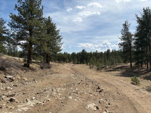
Then we found lots of spurs on both sides of the trail, heading down Badger Gulch on one side and down to the county road on the other side. There was too much to see! It's always frustrating to have to drive by trails we didn't have time to check out. It just means we'll have more to do next time.

The trail went around Boomer Mine and then it ended at Forest Service Road 896. We were shooting for the most direct north/south route, so we turned right there to head up to the La Salle Pass trailhead. When we got there, we found lots of construction equipment and torn-up spots, though the trail went through to the highway.

We knew that Highway 77 was closed in a section due to a helpful alert on the Pike National Forest website, but we weren't exactly sure where it was closed. We knew there was a possibility that we'd come out to a highway that wasn't available. When we got there, the pavement was dirt as they were still working on it. We watched two vehicles go by, heading north. Then, we saw both vehicles come back, returning south. That meant that we could head south, which was good news.

We decided to take on the dirt highway while still aired down, which turned out to be a good idea. It was pavement again by the time we got to the end of the Badger Flats trail, so we pulled back in there to air up at the nice spot for that there. We still had daylight left, which was nice.

Walt headed for home while Monica headed back to Lake George to stay another night under the stars. It was a great trip, and we still have so many more trails left to do in the area. Perfect!

afternoon_shadows
along_a_fence
badger_gulch_spur
beryllium
big_sky
boomer_spur
bumpy
campground_part_1
campground_part_2
campground_part_3
campground_part_4
campground_part_5
campground_part_6
campground_part_7
campground_part_8
climbing
construction
easy_road
fencing
flowers
gentle_climb
kiosk_part_1
kiosk_part_2
kiosk_part_3
kiosk_part_4
long_view
mellow
more_trails
mountain_peak
mountain_view
northern_end_sign
northern_kiosk
open_space
private
round_mountain_campground_sign
signs
spur_to_county_road_31
spur
start_of_the_trail
sun_and_shadows
trail_ahead
unexplored_spur
wide_trail
wildlife
Join Us!
If you aren’t a Member or Subscriber, you can’t see all of the content on this site. Get membership information to see why this site is best when you join and log in

Information for Subscribers

When you log in you’ll see more information here:

  • Recent Community Forum posts
  • Recent polls
  • Upcoming Events you can attend
  • Links to online users

© 2000-2022 · TrailDamage.com · Terms and Conditions · About · Contact
Trail information is only accurate on the date posted. Trails may have changed or closed since that date. Use this information for historical purposes only.
Contact the Forest Service or Bureau of Land Management for up-to-date trail information.

/* ----------------------------------------- */ /* View slug: reports-other-reports-for-same-trail-slider - start */ /* ----------------------------------------- */ /* place the prev/next controls on the sides */ .td-transition-controls .wpv-filter-next-link, .td-transition-controls .wpv-filter-previous-link { border: none; font-size: 300%; position: absolute; top: 70px; } .td-transition-controls .wpv-filter-previous-link { left: 0; } .td-transition-controls .wpv-filter-next-link { right: 0; } /* center the page selector horizonatally */ .td-transition-controls ul.wpv_pagination_dots { text-align: center; margin-top: 10px; } /* center the page selector horizonatally */ .td-transition-controls ul.wpv_pagination_dots li.wpv_pagination_dots_item, .td-transition-controls .wpv_pagination_dots li a { display: inline-block; float: none; } /* remove the default styles */ .td-transition-controls .wpv_pagination_dots li a { text-decoration: none; border-bottom: none; } .td-slider-container { padding: 0 25px; margin-bottom: 20px; position: relative; width:100%; display:table; } .td-slides { position: relative; } .td-slides-image { float:left; display:table-cell; } .td-slides-image img { border:1px solid #c0c0c0; } .td-slides-content { padding:4px 4px 4px 10px; border-top:1px solid #c0c0c0; border-right:1px solid #c0c0c0; border-bottom:1px solid #c0c0c0; display:table-cell; height:227px; overflow:hidden; } .td-slides-content h3 { margin-top:8px; } .td-slides-leader { font-size:smaller; margin-top:4px; } /* ----------------------------------------- */ /* View slug: reports-other-reports-for-same-trail-slider - end */ /* ----------------------------------------- */
/* ----------------------------------------- */ /* Content Template: Template for a Single Report - start */ /* ----------------------------------------- */ .entry-header { display:none; } .entry-content h1 { margin-top:16px; padding-top:0; } h1 a { color:#222; } h1 a:hover { color:#666; } p.entry-meta { font-size:small; } #report-body-spacer { clear:both; width:100%; height:20px; } #addtoany-bar { margin-bottom:2em; text-align:center; } .category-reports .post-info .author, .post-info .date { display: none; } .addthis_recommended_horizontal { text-align:center !important; } /* ----------------------------------------- */ /* Content Template: Template for a Single Report - end */ /* ----------------------------------------- */ /* ----------------------------------------- */ /* Content Template: Loop item in REPORTS Runners - start */ /* ----------------------------------------- */ #runners-container { width:100%; clear:both; } .runner { border:1px solid #c0c0c0; margin:0 6px 6px 0; float:left; width:49%; height:81px; } .runner-image { float: left; } .runner-image img { margin:2px 10px 0 2px; height:75px; width:75px; } .runner-name { text-transform:uppercase; } .runner-name a { color:#222; } .runner-name a:hover { color:#666; } .runner-vehicle { font-size:small; } @media only screen and (max-width: 768px) { .runner { width:100%; } } /* ----------------------------------------- */ /* Content Template: Loop item in REPORTS Runners - end */ /* ----------------------------------------- */