TrailDamage.com

Photos, videos and information about 4x4 trails in Colorado and Utah

  • Trails
    • Colorado
    • Utah
  • Reports
    • Featured Photos
    • Featured Videos
    • Reports Calendar
  • Members
  • Search
  • Trail Damage Winners
  • FAQ
  • Community
  • Upcoming Events
  • Membership
  • Log In
  • Facebook
  • Instagram
  • RSS
  • Twitter
  • YouTube

Predator 160812

August 12, 2016 by Monica

Predator

Trail Run on August 12, 2016
Report and photos by Monica I., Trail Leader
View trail information for Predator

Chad T.
Black 2006 Jeep Wrangler Unlimited
Matt K.
White 2016 Jeep Wrangler Unlimited Rubicon
Monica I.
Red 2010 Jeep Wrangler Rubicon

We had a full weekend of wheeling planned, with home base in Lake George. It's not a big town, and our campground was less than ideal. We met at the campground and got set up, and we were on the trail before noon. The weather promised to be perfect, and we were off to check out the Gulches.

From Lake George, it was a quick trip to Cedar Mountain Road. We only did a bit of it though, airing down a short distance into the trail. Our first stop was a new trail for us, and we found it easily enough. The GPS told us the trail's name is Predator.

It parallels Hackett Gulch, with the actual gulch between them. It stays up on the ridge for most of it. It was right in the middle of the burn area, too. We came across a truck on its way out right after we started down the trail, and then we had it to ourselves.

It was pretty mellow for most of it, with scenic views that wouldn't have been possible if all of the trees hadn't burned away. We were cruising along when Matt asked what was smoking. We stopped to find a tree that had been hit by lightening. It wasn't only smoking -- it was actually on fire.

There were bits of exploded tree around it, with small flames and smoke coming out of the top. Matt leaned a log against it so he could get to the top, and we handed him water bottles. He dumped water on it, and put it out after a few bottles. We hung out for a bit, peeling bark away from it just in case it was hot, still. We knew we'd be back to it, so we eventually left it to check it again later on the way back by.

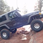
Then we were heading downhill fast. It was loose and rocky in spots, and we knew it would be fun on the way up. When we got to the wide spot that looked perfect for turning around, we all got out to walk the rest of it. The trail obviously continued, and after a bit of discussion we decided to go for it.

There is a rock slab along the way that was pretty fun, but then it was steep and there was nowhere to turn around. Monica made a 10-point turn in the middle of the hill while Matt and Chad went farther down to make their own 10-point turns on trail that was narrower but flatter. Though it was a fun side trail, we'd turn around at the wide spot next time.

The way back up was a blast. When we went by the tree again, the fire was still out. All was well, and we were lucky to catch it before a fire broke out. It was an interesting start to our trip! We finished up the trail and went over to do Hackett Gulch.

along_the_ridge
aspens
bumpy
burn_area
chad_and_matt
chad_on_the_trail
climbing
clouds
curve_with_a_view
deadwood
distance
downhill
end_of_the_trail
fire_part_1
fire_part_2
fire_part_3
fire_part_4
fire_part_5
fire_part_6
fire_part_7
fire_part_8
fire_part_9
hackett_gulch
hayman_fire_damage
in_the_trees
jeeps_on_the_trail
layers
little-used_trail
loose
matt_on_the_trail
matts_new_hood
mellow_section
monica_in_scenery
monica_on_the_trail
mountain_range
mountain_view
new_growth
no_hayman
open
parked
scenic
south_platte_river_valley_part_1
south_platte_river_valley_part_2
start_of_the_trail
trail_ahead
trailhead_sign
Join Us!
If you aren’t a Member or Subscriber, you can’t see all of the content on this site. Get membership information to see why this site is best when you join and log in

Information for Subscribers

When you log in you’ll see more information here:

  • Recent Community Forum posts
  • Recent polls
  • Upcoming Events you can attend
  • Links to online users

© 2000-2021 · TrailDamage.com · Terms and Conditions · About · Contact
Trail information is only accurate on the date posted. Trails may have changed or closed since that date. Use this information for historical purposes only.
Contact the Forest Service or Bureau of Land Management for up-to-date trail information.

/* ----------------------------------------- */ /* View slug: reports-other-reports-for-same-trail-slider - start */ /* ----------------------------------------- */ /* place the prev/next controls on the sides */ .td-transition-controls .wpv-filter-next-link, .td-transition-controls .wpv-filter-previous-link { border: none; font-size: 300%; position: absolute; top: 70px; } .td-transition-controls .wpv-filter-previous-link { left: 0; } .td-transition-controls .wpv-filter-next-link { right: 0; } /* center the page selector horizonatally */ .td-transition-controls ul.wpv_pagination_dots { text-align: center; margin-top: 10px; } /* center the page selector horizonatally */ .td-transition-controls ul.wpv_pagination_dots li.wpv_pagination_dots_item, .td-transition-controls .wpv_pagination_dots li a { display: inline-block; float: none; } /* remove the default styles */ .td-transition-controls .wpv_pagination_dots li a { text-decoration: none; border-bottom: none; } .td-slider-container { padding: 0 25px; margin-bottom: 20px; position: relative; width:100%; display:table; } .td-slides { position: relative; } .td-slides-image { float:left; display:table-cell; } .td-slides-image img { border:1px solid #c0c0c0; } .td-slides-content { padding:4px 4px 4px 10px; border-top:1px solid #c0c0c0; border-right:1px solid #c0c0c0; border-bottom:1px solid #c0c0c0; display:table-cell; height:227px; overflow:hidden; } .td-slides-content h3 { margin-top:8px; } .td-slides-leader { font-size:smaller; margin-top:4px; } /* ----------------------------------------- */ /* View slug: reports-other-reports-for-same-trail-slider - end */ /* ----------------------------------------- */
/* ----------------------------------------- */ /* Content Template: Template for a Single Report - start */ /* ----------------------------------------- */ .entry-header { display:none; } .entry-content h1 { margin-top:16px; padding-top:0; } h1 a { color:#222; } h1 a:hover { color:#666; } p.entry-meta { font-size:small; } #report-body-spacer { clear:both; width:100%; height:20px; } #addtoany-bar { margin-bottom:2em; text-align:center; } .category-reports .post-info .author, .post-info .date { display: none; } .addthis_recommended_horizontal { text-align:center !important; } /* ----------------------------------------- */ /* Content Template: Template for a Single Report - end */ /* ----------------------------------------- */ /* ----------------------------------------- */ /* Content Template: Loop item in REPORTS Runners - start */ /* ----------------------------------------- */ #runners-container { width:100%; clear:both; } .runner { border:1px solid #c0c0c0; margin:0 6px 6px 0; float:left; width:49%; height:81px; } .runner-image { float: left; } .runner-image img { margin:2px 10px 0 2px; height:75px; width:75px; } .runner-name { text-transform:uppercase; } .runner-name a { color:#222; } .runner-name a:hover { color:#666; } .runner-vehicle { font-size:small; } @media only screen and (max-width: 768px) { .runner { width:100%; } } /* ----------------------------------------- */ /* Content Template: Loop item in REPORTS Runners - end */ /* ----------------------------------------- */