TrailDamage.com

Photos, videos and information about 4x4 trails in Colorado and Utah

  • Trails
    • Colorado
    • Utah
  • Reports
    • Featured Photos
    • Featured Videos
    • Reports Calendar
  • Members
  • Search
  • Trail Damage Winners
  • FAQ
  • Community
  • Upcoming Events
  • Membership
  • Log In
  • Facebook
  • Instagram
  • RSS
  • Twitter
  • YouTube

Picayne Gulch 080827

August 27, 2008 by Monica

Picayne Gulch

Trail Run on August 27, 2008
Report and photos by Monica I., Trail Leader
View trail information for Picayne Gulch

Don W.
Silver 2005 Jeep Wrangler Rubicon
Monica I.
Red 2010 Jeep Wrangler Rubicon
Walt S.
Gray 2018 Jeep Wrangler Unlimited Rubicon
Michael M.
Black 2006 Jeep Wrangler Unlimited Rubicon

We stopped at a pullout just before getting to the trailhead because the views of the Animas River were really good. We also saw an old footbridge that we had to see from a closer view. It looked like it was rickety, even when it was together. We couldn't imagine actually using it.

We started up the trail, eventually, and the climb was fun from the start. This was already one of the best trails of the day and we weren't even very far into it. It was in trees, but it was fun.

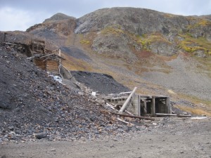
We were coming out of the trees when we came to the Treasure Mountain Mining Company buildings. We parked and got out to explore, and we were there awhile. There was so much to see. Vandals had messed it up a bit over the years, but you could still see how many of the rooms once looked. Across the way, the mill was very intact. Railroad ties went into the top, but they stuck out into mid-air where they had broken away from the building across the way. That building had sagged down quite a bit.

It was too much to explore in a short amount of time, unfortunately. We stayed awhile, but we had to leave long before we wanted to. We'd have to spend more time here the next time.

We went up and over to Placer Gulch and then headed down. We viewed all of the mining buildings from our Jeeps, but no one got out. There was just too much to see. We were soon on our way.

At the end of the trail, we pulled over and had our first evening meeting of the trip. Walt brought cashews and Don brought cookies. We discussed how we would finish the evening. Would we head over to Hurricane Pass and Corkscrew Gulch, hoping to air up before the sun went down? Or would we head back to Silverton now? Of course, the answer with us always involves doing more trails, so we turned left on California Gulch to head over to Hurricane Pass.

Do we even need to have these evening meetings? Probably not -- let's just do more trails!

animas_river
around_a_curve
climbing
county_road_sign
creek_part_1
creek_part_2
early_trail
elevation
eureka_mountain
gold_prince_mining_building_1
gold_prince_mining_building_2
gold_prince_mining_building_3
gold_prince_mining_building_4
gold_prince_mining_building_5
gold_prince_tramway_tower
long_trail
monica_at_the_treasure_mountain_mine
mountain_lake
old_mine
old_trail
placer_gulch_sign
placer_gulch
rolling_hills
snowfields
start_of_the_trail
to_the_bottom
trailhead_sign
treasure_mountain_mine_part_1
treasure_mountain_mine_part_2
treasure_mountain_mine_part_3
treasure_mountain_mine_part_4
treasure_mountain_mine_part_5
treasure_mountain_mine_part_6
treasure_mountain_mine_part_7
treasure_mountain_mine_part_8
treasure_mountain_mine_part_9
walkway_near_the_trailhead

Report from a Different Day

September 20, 2014

Led by Roger R.
We found the trailhead for Picayne Gulch just south of Animas Forks. We started up the trail, and the climb was fun from the start. This was already one of the best trails of the day and we weren’t even very far into it. It was in trees, but it…
Join Us!
If you aren’t a Member or Subscriber, you can’t see all of the content on this site. Get membership information to see why this site is best when you join and log in

Information for Subscribers

When you log in you’ll see more information here:

  • Recent Community Forum posts
  • Recent polls
  • Upcoming Events you can attend
  • Links to online users

© 2000-2021 · TrailDamage.com · Terms and Conditions · About · Contact
Trail information is only accurate on the date posted. Trails may have changed or closed since that date. Use this information for historical purposes only.
Contact the Forest Service or Bureau of Land Management for up-to-date trail information.

/* ----------------------------------------- */ /* View slug: reports-other-reports-for-same-trail-slider - start */ /* ----------------------------------------- */ /* place the prev/next controls on the sides */ .td-transition-controls .wpv-filter-next-link, .td-transition-controls .wpv-filter-previous-link { border: none; font-size: 300%; position: absolute; top: 70px; } .td-transition-controls .wpv-filter-previous-link { left: 0; } .td-transition-controls .wpv-filter-next-link { right: 0; } /* center the page selector horizonatally */ .td-transition-controls ul.wpv_pagination_dots { text-align: center; margin-top: 10px; } /* center the page selector horizonatally */ .td-transition-controls ul.wpv_pagination_dots li.wpv_pagination_dots_item, .td-transition-controls .wpv_pagination_dots li a { display: inline-block; float: none; } /* remove the default styles */ .td-transition-controls .wpv_pagination_dots li a { text-decoration: none; border-bottom: none; } .td-slider-container { padding: 0 25px; margin-bottom: 20px; position: relative; width:100%; display:table; } .td-slides { position: relative; } .td-slides-image { float:left; display:table-cell; } .td-slides-image img { border:1px solid #c0c0c0; } .td-slides-content { padding:4px 4px 4px 10px; border-top:1px solid #c0c0c0; border-right:1px solid #c0c0c0; border-bottom:1px solid #c0c0c0; display:table-cell; height:227px; overflow:hidden; } .td-slides-content h3 { margin-top:8px; } .td-slides-leader { font-size:smaller; margin-top:4px; } /* ----------------------------------------- */ /* View slug: reports-other-reports-for-same-trail-slider - end */ /* ----------------------------------------- */
/* ----------------------------------------- */ /* Content Template: Template for a Single Report - start */ /* ----------------------------------------- */ .entry-header { display:none; } .entry-content h1 { margin-top:16px; padding-top:0; } h1 a { color:#222; } h1 a:hover { color:#666; } p.entry-meta { font-size:small; } #report-body-spacer { clear:both; width:100%; height:20px; } #addtoany-bar { margin-bottom:2em; text-align:center; } .category-reports .post-info .author, .post-info .date { display: none; } .addthis_recommended_horizontal { text-align:center !important; } /* ----------------------------------------- */ /* Content Template: Template for a Single Report - end */ /* ----------------------------------------- */ /* ----------------------------------------- */ /* Content Template: Loop item in REPORTS Runners - start */ /* ----------------------------------------- */ #runners-container { width:100%; clear:both; } .runner { border:1px solid #c0c0c0; margin:0 6px 6px 0; float:left; width:49%; height:81px; } .runner-image { float: left; } .runner-image img { margin:2px 10px 0 2px; height:75px; width:75px; } .runner-name { text-transform:uppercase; } .runner-name a { color:#222; } .runner-name a:hover { color:#666; } .runner-vehicle { font-size:small; } @media only screen and (max-width: 768px) { .runner { width:100%; } } /* ----------------------------------------- */ /* Content Template: Loop item in REPORTS Runners - end */ /* ----------------------------------------- */