TrailDamage.com

Photos, videos and information about 4x4 trails in Colorado and Utah

  • Trails
    • Colorado
    • Utah
  • Reports
    • Featured Videos
    • Reports Calendar
  • Members
  • Search
  • Trail Damage Winners
  • FAQ
  • Community
  • Upcoming Events
  • Membership
  • Log In
  • Facebook
  • Instagram
  • RSS
  • Twitter
  • YouTube

Miners Gulch 160716

July 16, 2016 by Monica

Miners Gulch

Trail Run on July 16, 2016
Report and photos by Monica I., Trail Leader
View trail information for Miners Gulch

Monica I.
Red 2010 Jeep Wrangler Rubicon
Bryan P.
Teal 1993 Jeep Wrangler
Holly P.
Gray 2013 Jeep Wrangler Unlimited Rubicon
Jeffrey M.
Khaki 2006 Jeep Wrangler Unlimited Rubicon
Roger R.
White 2005 Jeep Wrangler Unlimited Rubicon
Matt K.
White 2016 Jeep Wrangler Unlimited Rubicon

We took the side trip off of Yankee Hill to do Miners Gulch, but we did it in a weird way. We wanted to see all of Yankee Hill, including the part between the start and end of Miners Gulch. So, we started at the eastern end, did Miners Hill, then did the whole Miners Gulch trail from west to east. It probably wasn't the best decision, as this is where all of the people were.

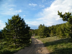
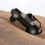
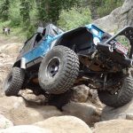
We had the beginning of Miners Gulch to ourselves. It was easy going, and we soon came to Miners Hill. We couldn't remember how steep it was, but it wasn't bad. It opened up at one point, and we stopped to get out and enjoy the scenery. The weather was perfect, so we took our time.

It seemed like a good idea to do the trail in reverse, but it wasn't. For one thing, that meant we did the hill in the downhill direction, making it much easier and not as much fun. For another thing, everyone else does it in the opposite direction. We ran into multiple groups of dirtbikes and ATVs, and it was kind of a mess at times. Lesson learned!

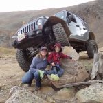
Just past the open spot at the bottom of the rocky hill, we took the spur over to the campsite. It was the perfect place for lunch, and we didn't see anyone else over there. We took our time just hanging out and enjoying ourselves.

We finally had to pack up and go, doing the rest of the trail in the opposite direction. We got lucky and didn't see anyone else on the way out. It's a fairly uneventful trail. It was the only place where everyone was quiet, just driving. Still, the weather was absolutely perfect.

When we were done, we lined up all of the Jeeps at the huge intersection at the trailhead for some group photos. Perfect! Then we headed west on Yankee Hill and to the rest of our day.

back_to_the_trailhead
camping_spot
colorful
creekside
down_the_rocky_hill_part_1
down_the_rocky_hill_part_2
down_the_rocky_hill_part_3
down_the_rocky_hill_part_4
down_the_rocky_hill_part_5
easy_curve
healthy_trees
layers
line_up_part_1
line_up_part_2
line_up_part_3
lunch
miners_hill_part_1
miners_hill_part_2
miners_hill_part_3
miners_hill_part_4
miners_hill_part_5
miners_hill_part_6
mountain_view
north_clear_creek
puddle
shadows
snow_in_the_distance
start_of_the_trail
trailhead_at_intersection
uphill
view_from_miners_hill

Reports from Other Days: 2

Use the arrows or dots to flip through the previews of the other reports for Miners Gulch. Click one of them to read more and see all of the photos from that day.

July 3, 2010

Led by Monica I.
It had already been a full day of wheeling complete with a relaxing BBQ at lunch time. The sun was threatening to go down as we turned off of the Sheridan Hill trail and started Miners Gulch. We still had some miles to cover, but we kept at it. We…
»
  • 1
  • 2
Join Us!
If you aren’t a Member or Subscriber, you can’t see all of the content on this site. Get membership information to see why this site is best when you join and log in

Information for Subscribers

When you log in you’ll see more information here:

  • Recent Community Forum posts
  • Recent polls
  • Upcoming Events you can attend
  • Links to online users

© 2000-2019 · TrailDamage.com · Terms and Conditions · About · Contact
Trail information is only accurate on the date posted. Trails may have changed or closed since that date. Use this information for historical purposes only.
Contact the Forest Service or Bureau of Land Management for up-to-date trail information.

/* ----------------------------------------- */ /* View slug: reports-other-reports-for-same-trail-slider - start */ /* ----------------------------------------- */ /* place the prev/next controls on the sides */ .td-transition-controls .wpv-filter-next-link, .td-transition-controls .wpv-filter-previous-link { border: none; font-size: 300%; position: absolute; top: 70px; } .td-transition-controls .wpv-filter-previous-link { left: 0; } .td-transition-controls .wpv-filter-next-link { right: 0; } /* center the page selector horizonatally */ .td-transition-controls ul.wpv_pagination_dots { text-align: center; margin-top: 10px; } /* center the page selector horizonatally */ .td-transition-controls ul.wpv_pagination_dots li.wpv_pagination_dots_item, .td-transition-controls .wpv_pagination_dots li a { display: inline-block; float: none; } /* remove the default styles */ .td-transition-controls .wpv_pagination_dots li a { text-decoration: none; border-bottom: none; } .td-slider-container { padding: 0 25px; margin-bottom: 20px; position: relative; width:100%; display:table; } .td-slides { position: relative; } .td-slides-image { float:left; display:table-cell; } .td-slides-image img { border:1px solid #c0c0c0; } .td-slides-content { padding:4px 4px 4px 10px; border-top:1px solid #c0c0c0; border-right:1px solid #c0c0c0; border-bottom:1px solid #c0c0c0; display:table-cell; height:227px; overflow:hidden; } .td-slides-content h3 { margin-top:8px; } .td-slides-leader { font-size:smaller; margin-top:4px; } /* ----------------------------------------- */ /* View slug: reports-other-reports-for-same-trail-slider - end */ /* ----------------------------------------- */
/* ----------------------------------------- */ /* Content Template: Template for a Single Report - start */ /* ----------------------------------------- */ .entry-header { display:none; } .entry-content h1 { margin-top:16px; padding-top:0; } h1 a { color:#222; } h1 a:hover { color:#666; } p.entry-meta { font-size:small; } #report-body-spacer { clear:both; width:100%; height:20px; } #addtoany-bar { margin-bottom:2em; text-align:center; } .category-reports .post-info .author, .post-info .date { display: none; } .addthis_recommended_horizontal { text-align:center !important; } /* ----------------------------------------- */ /* Content Template: Template for a Single Report - end */ /* ----------------------------------------- */ /* ----------------------------------------- */ /* Content Template: Loop item in REPORTS Runners - start */ /* ----------------------------------------- */ #runners-container { width:100%; clear:both; } .runner { border:1px solid #c0c0c0; margin:0 6px 6px 0; float:left; width:49%; height:81px; } .runner-image { float: left; } .runner-image img { margin:2px 10px 0 2px; height:75px; width:75px; } .runner-name { text-transform:uppercase; } .runner-name a { color:#222; } .runner-name a:hover { color:#666; } .runner-vehicle { font-size:small; } @media only screen and (max-width: 768px) { .runner { width:100%; } } /* ----------------------------------------- */ /* Content Template: Loop item in REPORTS Runners - end */ /* ----------------------------------------- */