TrailDamage.com

Photos, videos and information about 4x4 trails in Colorado and Utah

  • Trails
    • Colorado
    • Utah
  • Reports
    • Featured Photos
    • Featured Videos
    • Reports Calendar
  • Members
  • Search
  • Trail Damage Winners
  • FAQ
  • Community
  • Upcoming Events
  • Membership
  • Log In
  • Facebook
  • Instagram
  • RSS
  • Twitter
  • YouTube

Mineral Creek 080830

August 30, 2008 by Monica

Mineral Creek

Trail Run on August 30, 2008
Report and photos by Monica I., Trail Leader
View trail information for Mineral Creek

Michael M.
Black 2006 Jeep Wrangler Unlimited Rubicon
Walt S.
Gray 2018 Jeep Wrangler Unlimited Rubicon
Don W.
Silver 2005 Jeep Wrangler Rubicon

Mineral Creek is definitely a fun trail, but doing it first thing on a Saturday morning in August meant there was lots of traffic. We shared the trail with vehicles and ATVs going both directions, and many of the drivers were in a bit over their heads. Still, we had a great time on the bumpy stuff.

We aired down at the trailhead with lots of other people. We were getting ready with the people we finished Black Bear Pass with the day before, and we were all chatting. It looked like it was going to be a great day, with perfect weather.

We soon got started, and it was bumpy right away. We saw the Michael Breen Mine, but didn't stop. When we got to the intersection with Poughkeepsie Gulch, we passed it. Our plan was to check out the rest of Mineral Creek and then double back to do Poughkeepsie Gulch.

We took the detour to Mineral Point, noticing that the trail to the marker for Mineral Point hasn't been used in a long time. It is closed off, now. We did see some vehicles way off in the distance, and we guessed that they had used the illegal trail, anyway. It probably needs to be marked a bit better.

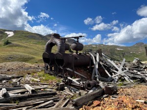
We continued on, and the trail snaked around through the mines. It was tight in places, and a good time as we worked our way back to the main trail. We checked out the San Juan Chief Mine, but only viewed the British Queen Mine from the trail. This looked like a popular ATV spot.

We kept going to the end of the trail, and just before the intersection with Engineer Pass we passed an older vehicle with a flat all-terrain tire. They said they had everything they needed, so we passed by. We soon made it to the end and turned around, so we passed them again in a matter of a few minutes. They probably thought we were lost.

We worked our way back to Poughkeepsie Gulch, and we didn't see as much traffic. Maybe it was all on its way to the Alpine Loop. Not us, though, we were doing Poughkeepsie Gulch!

airing_down
around_a_curve
back_to_poughkeepsie_gulch
bumpy
climbing
deer
early_bumps
michael_breen_mine
mine_ruins
mineral_creek
mineral_point_bumps
mineral_point_sign
mineral_point_trails
mountain_view
near_engineer_pass
old_cabin_1
old_cabin_2
open_trail
poughkeepsie_gulch_sign_1
poughkeepsie_gulch_sign_2
san_juan_chief_mine_part_1
san_juan_chief_mine_part_2
san_juan_chief_mine_part_3
shelf_road
sign_at_the_end_1
sign_at_the_end_2
snow_on_a_distant_mountain
snowfield_over_the_creek
start_of_the_trail
switchback
tiny_waterfall
trailhead_sign_1
trailhead_sign_2
trailhead_sign_3
uphill
valley_view
view_at_the_end
view_from_the_san_juan_chief_mine
walt_on_the_trail
water_crossing

Report from a Different Day

August 20, 2004

Led by Monica I.
We started the trail and ended up a little surprised to find it a little rocky in places. You could definitely find your way around the rockier sections and make it fairly easy if you wanted. Of course most of us took the rockiest lines. There was one part with…
Join Us!
If you aren’t a Member or Subscriber, you can’t see all of the content on this site. Get membership information to see why this site is best when you join and log in

Information for Subscribers

When you log in you’ll see more information here:

  • Recent Community Forum posts
  • Recent polls
  • Upcoming Events you can attend
  • Links to online users

© 2000-2021 · TrailDamage.com · Terms and Conditions · About · Contact
Trail information is only accurate on the date posted. Trails may have changed or closed since that date. Use this information for historical purposes only.
Contact the Forest Service or Bureau of Land Management for up-to-date trail information.

/* ----------------------------------------- */ /* View slug: reports-other-reports-for-same-trail-slider - start */ /* ----------------------------------------- */ /* place the prev/next controls on the sides */ .td-transition-controls .wpv-filter-next-link, .td-transition-controls .wpv-filter-previous-link { border: none; font-size: 300%; position: absolute; top: 70px; } .td-transition-controls .wpv-filter-previous-link { left: 0; } .td-transition-controls .wpv-filter-next-link { right: 0; } /* center the page selector horizonatally */ .td-transition-controls ul.wpv_pagination_dots { text-align: center; margin-top: 10px; } /* center the page selector horizonatally */ .td-transition-controls ul.wpv_pagination_dots li.wpv_pagination_dots_item, .td-transition-controls .wpv_pagination_dots li a { display: inline-block; float: none; } /* remove the default styles */ .td-transition-controls .wpv_pagination_dots li a { text-decoration: none; border-bottom: none; } .td-slider-container { padding: 0 25px; margin-bottom: 20px; position: relative; width:100%; display:table; } .td-slides { position: relative; } .td-slides-image { float:left; display:table-cell; } .td-slides-image img { border:1px solid #c0c0c0; } .td-slides-content { padding:4px 4px 4px 10px; border-top:1px solid #c0c0c0; border-right:1px solid #c0c0c0; border-bottom:1px solid #c0c0c0; display:table-cell; height:227px; overflow:hidden; } .td-slides-content h3 { margin-top:8px; } .td-slides-leader { font-size:smaller; margin-top:4px; } /* ----------------------------------------- */ /* View slug: reports-other-reports-for-same-trail-slider - end */ /* ----------------------------------------- */
/* ----------------------------------------- */ /* Content Template: Template for a Single Report - start */ /* ----------------------------------------- */ .entry-header { display:none; } .entry-content h1 { margin-top:16px; padding-top:0; } h1 a { color:#222; } h1 a:hover { color:#666; } p.entry-meta { font-size:small; } #report-body-spacer { clear:both; width:100%; height:20px; } #addtoany-bar { margin-bottom:2em; text-align:center; } .category-reports .post-info .author, .post-info .date { display: none; } .addthis_recommended_horizontal { text-align:center !important; } /* ----------------------------------------- */ /* Content Template: Template for a Single Report - end */ /* ----------------------------------------- */ /* ----------------------------------------- */ /* Content Template: Loop item in REPORTS Runners - start */ /* ----------------------------------------- */ #runners-container { width:100%; clear:both; } .runner { border:1px solid #c0c0c0; margin:0 6px 6px 0; float:left; width:49%; height:81px; } .runner-image { float: left; } .runner-image img { margin:2px 10px 0 2px; height:75px; width:75px; } .runner-name { text-transform:uppercase; } .runner-name a { color:#222; } .runner-name a:hover { color:#666; } .runner-vehicle { font-size:small; } @media only screen and (max-width: 768px) { .runner { width:100%; } } /* ----------------------------------------- */ /* Content Template: Loop item in REPORTS Runners - end */ /* ----------------------------------------- */