TrailDamage.com

Photos, videos and information about 4x4 trails in Colorado and Utah

  • Trails
    • Colorado
    • Utah
  • Reports
    • Featured Photos
    • Featured Videos
    • Reports Calendar
  • Members
  • Search
  • Trail Damage Winners
  • FAQ
  • Community
  • Upcoming Events
  • Membership
  • Log In
  • Facebook
  • Instagram
  • RSS
  • Twitter
  • YouTube

Liberty Trail 060909

September 9, 2006 by Monica

Liberty Trail

Trail Run on September 9, 2006
Report and photos by Monica I., Trail Leader
View trail information for Liberty Trail

Monica I.
Red 2010 Jeep Wrangler Rubicon
Mark G.
Green 1993 Jeep Wrangler

We had just two Jeeps on the trail this time, with Mike S. hiking alongside us as we wheeled it. He was always faster than we were as we worked our way to the end. It was a great trip to the southern tip of the trail, as always.

Even the entrance was fun, so it started off right. Monica was first on the way in, and she got tippy near the end but it was fine. Mark got tippy too but he drove right through it.

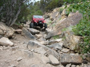
We had a blast on the early rocks, weaving our way around them or over them. No one caught a corner panel here, unlike last time. It felt good to escape it.

We played in the Gap, and both Monica and Mark straddled it on the way through without any issues.

It wasn't long at all before we got to the Waterfall. We had a quick lunch and talked about who would go down it and who would go around it. Monica had been down it twice already this year and hit her spare tire carrier both times (both times requiring a weld to fix the breaks), so she decided to go around it this time.

Mark wasn't about to go around it, though, so he lined up and headed down. He used a modified version of the line down the side where you aren't airborne, and it worked out well. He rode his passenger tires along the rocky side and flexed his way through it. He was definitely tippy but in no danger of going over. He didn't even get stuck between the rocks and the tree. Nice!

Monica worked her way down the V and stopped just above the Wall to watch Mark come down the V. That's when we all heard a lot of air come out of one of Mark's tires. Mike took a look and found a huge cut in Mark's front passenger-side tire. It must have been pinched between a rock and his rim, slicing through the sidewall.

It was too difficult to Hi-Lift it where it was, so Mark backed up just a bit to get in a better place. Then he lifted it and changed the tire. He had a cordless impact wrench that made the job go by very quickly, which was cool. He aired the spare tire down too far (that always happens!) and had to air up a little bit before leaving, but it wasn't long before he was down the V and we were on our way.

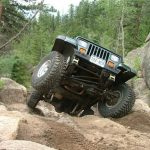
Monica went down the Wall and through the next bit of challenging rocks, then went back to watch Mark. Mark came down the Wall with no issues at all, but then straddled a big rock at the bottom and he was high centered.

Mike and Mark worked on getting him off the rock, but in the end Mark used his winch to pull himself sideways enough to get off of it. Then he immediately ended up on another rock and stuck again. A little bit of stacking got him off of that one, though. It's amazing how changing your line just a little bit on Liberty will really get you stuck.

We had to pose on the Cube, of course. Monica got some great flex and some great pictures. Mark did the same and got some amazing flex out of his YJ. We both had a hard time getting back into our Jeeps because the driver's seat was so high in the air.

It was nice to have a bit of relaxing trail, then we started in on the last bit of rocks. Mark ended up with a rear tire in a hole and got a great wheel stand, and had a good time getting through it. He also noticed that he had managed to hit his passenger-side fender flares somewhere along the trail and both of them were off at one end.

The last bit actually had a foot of standing water around it, which we thought might make it a bit tougher. It didn't end up changing things, though, which was good.

Monica weaved her way around the big rock and had to work on not getting high centered there, but she got around it. The last set of rocks were just as interesting as always, and the drop off was a bit more severe because the mud had been dug out a bit.

Mark came through it without any issues, and the drop off at the end was also pretty steep for him.

We had walked up Patriot Trail and down Freedom Trail and the bottom half of Independence Trail before finishing up with Liberty Trail. After a little discussion we decided that instead of spending the next five or six hours working our way back out Liberty we were going to try to get up Bunker Hill on Independence. There were a few buggies there, but we got in line and headed out.

Liberty is such a great trail, and we had a great time!

airing_down
easiest_part
jumbled_rocks
mark_airing_down
mark_at_the_end_part_1
mark_at_the_end_part_2
mark_at_the_end_part_3
mark_at_the_end_part_4
mark_at_the_end_part_5
mark_at_the_end_part_6
mark_at_the_end_part_7
mark_at_the_gap_part_1
mark_at_the_gap_part_2
mark_at_the_gap_part_3
mark_at_the_start_part_1
mark_at_the_start_part_2
mark_at_the_start_part_3
mark_at_the_start_part_4
mark_at_the_start_part_5
mark_down_the_wall_part_1
mark_down_the_wall_part_2
mark_down_the_wall_part_3
mark_down_the_wall_part_4
mark_down_the_wall_part_5
mark_down_the_wall_part_6
mark_down_the_wall_part_7
mark_down_the_wall_part_8
mark_down_the_wall_part_9
mark_down_the_waterfall_part_1
mark_down_the_waterfall_part_2
mark_down_the_waterfall_part_3
mark_down_the_waterfall_part_4
mark_down_the_waterfall_part_5
mark_down_the_waterfall_part_6
mark_down_the_waterfall_part_7
mark_down_the_waterfall_part_8
mark_down_the_waterfall_part_9
mark_in_rocks_part_1
mark_in_rocks_part_2
mark_in_rocks_part_3
mark_in_rocks_part_4
mark_in_rocks_part_5
mark_in_the_v
mark_on_the_cube_part_1
mark_on_the_cube_part_2
mark_on_the_cube_part_3
mark_on_the_cube_part_4
mark_on_the_cube_part_5
mark_on_the_cube_part_6
mark_on_the_cube_part_7
mark_through_some_rocks_part_1
mark_through_some_rocks_part_2
mark_through_some_rocks_part_3
mark_through_some_rocks_part_4
mark_through_some_rocks_part_5
mark_through_some_rocks_part_6
mark_through_some_rocks_part_7
mark_through_some_rocks_part_8
mark_through_some_rocks_part_9
mark_trail_damage_part_1
mark_trail_damage_part_2
mark_trail_damage_part_3
mark_trail_damage_part_4
mark_trail_damage_part_5
mark_trail_damage_part_6
mark_trail_damage_part_7
mark_trail_damage_part_8
mark_trail_damage_part_9
monica_airing_down
monica_at_the_end_part_1
monica_at_the_end_part_2
monica_at_the_end_part_3
monica_at_the_end_part_4
monica_at_the_start_part_1
monica_at_the_start_part_2
monica_at_the_start_part_3
monica_at_the_start_part_4
monica_at_the_start_part_5
monica_down_the_wall_part_1
monica_down_the_wall_part_2
monica_on_the_cube_part_1
monica_on_the_cube_part_2
monica_on_the_cube_part_3
our_jeeps_seen_from_the_ridge
start_of_the_trail
trailhead
water_near_the_end

Reports from Other Days: 4

Use the arrows or dots to flip through the previews of the other reports for Liberty Trail. Click one of them to read more and see all of the photos from that day.

June 27, 2010

Led by Monica I.
We headed off from our meeting place in Castle Rock and got down to Penrose at around 11AM, so we made pretty good time. Although there were quite a few trailers and vehicles at the trailhead, we really didn’t have to wait on any other groups throughout the day. Everybody…
»
  • 1
  • 2
  • 3
  • 4
Join Us!
If you aren’t a Member or Subscriber, you can’t see all of the content on this site. Get membership information to see why this site is best when you join and log in

Information for Subscribers

When you log in you’ll see more information here:

  • Recent Community Forum posts
  • Recent polls
  • Upcoming Events you can attend
  • Links to online users

© 2000-2022 · TrailDamage.com · Terms and Conditions · About · Contact
Trail information is only accurate on the date posted. Trails may have changed or closed since that date. Use this information for historical purposes only.
Contact the Forest Service or Bureau of Land Management for up-to-date trail information.

/* ----------------------------------------- */ /* View slug: reports-other-reports-for-same-trail-slider - start */ /* ----------------------------------------- */ /* place the prev/next controls on the sides */ .td-transition-controls .wpv-filter-next-link, .td-transition-controls .wpv-filter-previous-link { border: none; font-size: 300%; position: absolute; top: 70px; } .td-transition-controls .wpv-filter-previous-link { left: 0; } .td-transition-controls .wpv-filter-next-link { right: 0; } /* center the page selector horizonatally */ .td-transition-controls ul.wpv_pagination_dots { text-align: center; margin-top: 10px; } /* center the page selector horizonatally */ .td-transition-controls ul.wpv_pagination_dots li.wpv_pagination_dots_item, .td-transition-controls .wpv_pagination_dots li a { display: inline-block; float: none; } /* remove the default styles */ .td-transition-controls .wpv_pagination_dots li a { text-decoration: none; border-bottom: none; } .td-slider-container { padding: 0 25px; margin-bottom: 20px; position: relative; width:100%; display:table; } .td-slides { position: relative; } .td-slides-image { float:left; display:table-cell; } .td-slides-image img { border:1px solid #c0c0c0; } .td-slides-content { padding:4px 4px 4px 10px; border-top:1px solid #c0c0c0; border-right:1px solid #c0c0c0; border-bottom:1px solid #c0c0c0; display:table-cell; height:227px; overflow:hidden; } .td-slides-content h3 { margin-top:8px; } .td-slides-leader { font-size:smaller; margin-top:4px; } /* ----------------------------------------- */ /* View slug: reports-other-reports-for-same-trail-slider - end */ /* ----------------------------------------- */
/* ----------------------------------------- */ /* Content Template: Template for a Single Report - start */ /* ----------------------------------------- */ .entry-header { display:none; } .entry-content h1 { margin-top:16px; padding-top:0; } h1 a { color:#222; } h1 a:hover { color:#666; } p.entry-meta { font-size:small; } #report-body-spacer { clear:both; width:100%; height:20px; } #addtoany-bar { margin-bottom:2em; text-align:center; } .category-reports .post-info .author, .post-info .date { display: none; } .addthis_recommended_horizontal { text-align:center !important; } /* ----------------------------------------- */ /* Content Template: Template for a Single Report - end */ /* ----------------------------------------- */ /* ----------------------------------------- */ /* Content Template: Loop item in REPORTS Runners - start */ /* ----------------------------------------- */ #runners-container { width:100%; clear:both; } .runner { border:1px solid #c0c0c0; margin:0 6px 6px 0; float:left; width:49%; height:81px; } .runner-image { float: left; } .runner-image img { margin:2px 10px 0 2px; height:75px; width:75px; } .runner-name { text-transform:uppercase; } .runner-name a { color:#222; } .runner-name a:hover { color:#666; } .runner-vehicle { font-size:small; } @media only screen and (max-width: 768px) { .runner { width:100%; } } /* ----------------------------------------- */ /* Content Template: Loop item in REPORTS Runners - end */ /* ----------------------------------------- */