TrailDamage.com

Photos, videos and information about 4x4 trails in Colorado and Utah

  • Trails
    • Colorado
    • Utah
  • Reports
    • Featured Photos
    • Featured Videos
    • Reports Calendar
  • Members
  • Search
  • Trail Damage Winners
  • FAQ
  • Community
  • Upcoming Events
  • Membership
  • Log In
  • Facebook
  • Instagram
  • RSS
  • Twitter
  • YouTube

Kingston Peak 070910

September 10, 2007 by Monica

Kingston Peak

Trail Run on September 10, 2007
Report and photos by Monica I., Trail Leader
View trail information for Kingston Peak

Monica I.
Red 2010 Jeep Wrangler Rubicon
Walt S.
Gray 2022 Jeep Wrangler Unlimited Rubicon 392
Mark F.
Blue 2002 Jeep Wrangler

It's usually insanely windy and cold on Kingston Peak, and this trip was no exception. Monica didn't have a muffler attached, so she had her windows out and it made things a lot colder. Still, the sun was out and the scenery was gorgeous.

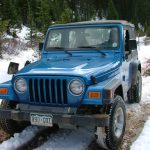
We started at the trail's intersection with Apex Road so we missed the climb up from Rollinsville. That put us at the mud puddles pretty quickly, just after we climbed above timberline. Monica and Walt bypassed the mud, but Mark got in it.

Mark remembered them being a bit more shallow, so he went through them with a lot of gusto. That meant he got some great splashes and had a great time in the muddy water.

After the puddles we headed off to the long portion of shelf road before the overlook at the James Peak hiking trail. It was very windy, but beautiful. We didn't see anyone else on the trail, so we didn't have to worry about passing anyone here.

When we got to the overlook, it was really, really windy. Mark got out, but Walt and Monica stayed in their vehicles. We didn't stay long in that wind!

The climb up from the overlook is always a good time. No one had any issues as we all enjoyed the hill.

The views at the top were phenomenal, and we all noted that we could still see the bad weather below us. We wondered if it was raining and just as cold.

We were quickly down to the low part and working our way across it to the next hill. When we went up the hill we noticed that the alternate routes were closed now. There is only one route up the hill, but it was still a fun one.

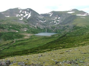
Once at the top, we stopped at the rock house. Walt put a new rock on the house for good luck, and everyone snapped pictures of Loch Lomond and Chinns Lake below us.

The "enchanted forest" was as strange as ever as we worked our way down the hill to Alice. When we got to Alice we decided that we'd add another new trail to the day and head over to do Chinns Lake. Kingston Peak is one of our favorites, even if it's too windy to even walk around. It was a beautiful trail.

above_the_weather
above_timberline
around_to_the_overlook
big_view
chinns_lake
climb_from_the_overlook
down_to_the_bottom
empire
enchanted_forest
exposed
hiking_trail
instructional_sign
james_peak_hiking_trail
leaving_the_overlook
little_echo_lake
loch_lomond
long_trail
mark_and_walt_at_the_overlook
mark_through_the_mud_part_1
mark_through_the_mud_part_2
mark_through_the_mud_part_3
mark_through_the_mud_part_4
mark_through_the_mud_part_5
mark_through_the_mud_part_6
mark_through_the_mud_part_7
mark_through_the_mud_part_8
mellow_trail
mud_puddles
nearing_timberline
rock_house_part_1
rock_house_part_2
rocky_climb
second_uphill
shelf_road
to_alice
trail_below_us
trail_in_front_of_us
trail_in_scenery
trail_sign
uphill
view_from_the_top_part_1
view_from_the_top_part_2
view_from_the_top_part_3
view_from_the_top_part_4
view_from_the_top_part_5
walt_nearing_the_overlook
water_on_the_trail
yankee_hill

Reports from Other Days: 10

Use the arrows or dots to flip through the previews of the other reports for Kingston Peak. Click one of them to read more and see all of the photos from that day.

September 20, 2003

Led by Monica I.
There was a dusting of snow on all of the peaks around the trail and we saw snow in places along the trail too. Ladd’s thermometer said it was 40 degrees, but that wasn’t including the wind chill factor. The wind was strong enough to make you lose your balance…
« »
  • 1
  • 2
  • 3
  • 4
  • 5
  • 6
  • 7
  • 8
  • 9
  • 10
Join Us!
If you aren’t a Member or Subscriber, you can’t see all of the content on this site. Get membership information to see why this site is best when you join and log in

Information for Subscribers

When you log in you’ll see more information here:

  • Recent Community Forum posts
  • Recent polls
  • Upcoming Events you can attend
  • Links to online users

© 2000-2023 · TrailDamage.com · Terms and Conditions · About · Contact
Trail information is only accurate on the date posted. Trails may have changed or closed since that date. Use this information for historical purposes only.
Contact the Forest Service or Bureau of Land Management for up-to-date trail information.

/* ----------------------------------------- */ /* View slug: reports-other-reports-for-same-trail-slider - start */ /* ----------------------------------------- */ /* place the prev/next controls on the sides */ .td-transition-controls .wpv-filter-next-link, .td-transition-controls .wpv-filter-previous-link { border: none; font-size: 300%; position: absolute; top: 70px; } .td-transition-controls .wpv-filter-previous-link { left: 0; } .td-transition-controls .wpv-filter-next-link { right: 0; } /* center the page selector horizonatally */ .td-transition-controls ul.wpv_pagination_dots { text-align: center; margin-top: 10px; } /* center the page selector horizonatally */ .td-transition-controls ul.wpv_pagination_dots li.wpv_pagination_dots_item, .td-transition-controls .wpv_pagination_dots li a { display: inline-block; float: none; } /* remove the default styles */ .td-transition-controls .wpv_pagination_dots li a { text-decoration: none; border-bottom: none; } .td-slider-container { padding: 0 25px; margin-bottom: 20px; position: relative; width:100%; display:table; } .td-slides { position: relative; } .td-slides-image { float:left; display:table-cell; } .td-slides-image img { border:1px solid #c0c0c0; } .td-slides-content { padding:4px 4px 4px 10px; border-top:1px solid #c0c0c0; border-right:1px solid #c0c0c0; border-bottom:1px solid #c0c0c0; display:table-cell; height:227px; overflow:hidden; } .td-slides-content h3 { margin-top:8px; } .td-slides-leader { font-size:smaller; margin-top:4px; } /* ----------------------------------------- */ /* View slug: reports-other-reports-for-same-trail-slider - end */ /* ----------------------------------------- */
/* ----------------------------------------- */ /* Content Template: Template for a Single Report - start */ /* ----------------------------------------- */ .entry-header { display:none; } .entry-content h1 { margin-top:16px; padding-top:0; } h1 a { color:#222; } h1 a:hover { color:#666; } p.entry-meta { font-size:small; } #report-body-spacer { clear:both; width:100%; height:20px; } #addtoany-bar { margin-bottom:2em; text-align:center; } .category-reports .post-info .author, .post-info .date { display: none; } .addthis_recommended_horizontal { text-align:center !important; } /* ----------------------------------------- */ /* Content Template: Template for a Single Report - end */ /* ----------------------------------------- */ /* ----------------------------------------- */ /* Content Template: Loop item in REPORTS Runners - start */ /* ----------------------------------------- */ #runners-container { width:100%; clear:both; } .runner { border:1px solid #c0c0c0; margin:0 6px 6px 0; float:left; width:49%; height:81px; } .runner-image { float: left; } .runner-image img { margin:2px 10px 0 2px; height:75px; width:75px; } .runner-name { text-transform:uppercase; } .runner-name a { color:#222; } .runner-name a:hover { color:#666; } .runner-vehicle { font-size:small; } @media only screen and (max-width: 768px) { .runner { width:100%; } } /* ----------------------------------------- */ /* Content Template: Loop item in REPORTS Runners - end */ /* ----------------------------------------- */