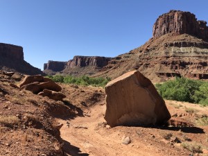
TrailDamage.com

Photos, videos and information about 4x4 trails in Colorado and Utah

  • Trails
    • Colorado
    • Utah
  • Reports
    • Featured Photos
    • Featured Videos
    • Reports Calendar
  • Members
  • Search
  • Trail Damage Winners
  • FAQ
  • Community
  • Upcoming Events
  • Membership
  • Log In
  • Facebook
  • Instagram
  • RSS
  • Twitter
  • YouTube

Kane Creek Canyon 021018

October 18, 2002 by Monica

Kane Creek Canyon

Trail Run on October 18, 2002
Report and photos by Monica I., Trail Leader
View trail information for Kane Creek Canyon

Dave R.
Blue 2001 Jeep Wrangler
Monica I.
Red 2010 Jeep Wrangler Rubicon
Beth G.
Black 1990 Jeep Wrangler

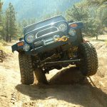
We were really looking forward to this trail -- and it was worth the drive. There were lots of places where you could either drive straight up something or go around (we usually chose stright up, of course).

We even had the "Moab Sand Races" where we got our Wranglers in a row and let off the clutch at the same time, crawling to the finish line. Monica needs her gears adjusted and beat everyone there by a long shot.

It's a very dusty place and you'll be covered in that red Moab dust right away. It's very red, with a very blue sky and green bushes up to about the middle of both sides of the canyon. There were too many nature photos to be taken.

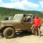
The floor of the canyon is fun too, with blind curves in sand and sudden creek crossings. We were crossing yet another place when a girl came running up to us out of nowhere. It turns out her boyfriend drove his Cherokee (XJ) into a large hole of water and couldn't get out.

We drove and walked over through the water to go check it out and nearly the entire front end was under water, just about up to the windshield wipers. The open tailgate was about 6 inches from flooding the inside with water too. The inside of the Jeep was also flooded with water.

We tried a few different ways -- including hooking all three Wranglers up with tow straps and pulling -- but we couldn't get him out because we were all in the Creek. Finally Dave hooked up his winch and managed to pull the Cherokee out.

We made sure they were okay and went on our way. The Cherokee died again later and we waited with him until he got it going again. Then later a dirt bike chain broke and we helped someone else.

We didn't end up finishing the trail -- we only made it deep into the canyon and water crossings before the sun started going down. We probably could have started earlier, but we spent quite a few hours helping other people too. We still had a good time, and I'd like to do this trail again.

beth_at_lunch
beth_playing_in_the_sand
beth_posing_part_1
beth_posing_part_2
beth_posing_part_3
beth_posing_part_4
beth_taking_a_walk
bottom_of_the_canyon
canyon_shot
dog_rock_part_1
dog_rock_part_2
horseshoe_hill
kane_creek_sunset
kane_creek
lunch_part_1
lunch_part_2
monica_from_the_top_of_horseshoe_hill
monica_posing_again
monica_posing
old_corral
scenic
starting_out_part_1
starting_out_part_2
starting_out_part_3
starting_out_part_4

Reports from Other Days: 4

Use the arrows or dots to flip through the previews of the other reports for Kane Creek Canyon. Click one of them to read more and see all of the photos from that day.

May 25, 2020

Led by Matt K.
As we went to Kane Creek Canyon, we stopped just before the dirt road starts and aired down. Then we made our way to the start of Kane Creek Canyon. We waited at the start of the trail for a few minutes to give a group in front some space….
»
  • 1
  • 2
  • 3
  • 4
Join Us!
If you aren’t a Member or Subscriber, you can’t see all of the content on this site. Get membership information to see why this site is best when you join and log in

Information for Subscribers

When you log in you’ll see more information here:

  • Recent Community Forum posts
  • Recent polls
  • Upcoming Events you can attend
  • Links to online users

© 2000-2022 · TrailDamage.com · Terms and Conditions · About · Contact
Trail information is only accurate on the date posted. Trails may have changed or closed since that date. Use this information for historical purposes only.
Contact the Forest Service or Bureau of Land Management for up-to-date trail information.

/* ----------------------------------------- */ /* View slug: reports-other-reports-for-same-trail-slider - start */ /* ----------------------------------------- */ /* place the prev/next controls on the sides */ .td-transition-controls .wpv-filter-next-link, .td-transition-controls .wpv-filter-previous-link { border: none; font-size: 300%; position: absolute; top: 70px; } .td-transition-controls .wpv-filter-previous-link { left: 0; } .td-transition-controls .wpv-filter-next-link { right: 0; } /* center the page selector horizonatally */ .td-transition-controls ul.wpv_pagination_dots { text-align: center; margin-top: 10px; } /* center the page selector horizonatally */ .td-transition-controls ul.wpv_pagination_dots li.wpv_pagination_dots_item, .td-transition-controls .wpv_pagination_dots li a { display: inline-block; float: none; } /* remove the default styles */ .td-transition-controls .wpv_pagination_dots li a { text-decoration: none; border-bottom: none; } .td-slider-container { padding: 0 25px; margin-bottom: 20px; position: relative; width:100%; display:table; } .td-slides { position: relative; } .td-slides-image { float:left; display:table-cell; } .td-slides-image img { border:1px solid #c0c0c0; } .td-slides-content { padding:4px 4px 4px 10px; border-top:1px solid #c0c0c0; border-right:1px solid #c0c0c0; border-bottom:1px solid #c0c0c0; display:table-cell; height:227px; overflow:hidden; } .td-slides-content h3 { margin-top:8px; } .td-slides-leader { font-size:smaller; margin-top:4px; } /* ----------------------------------------- */ /* View slug: reports-other-reports-for-same-trail-slider - end */ /* ----------------------------------------- */
/* ----------------------------------------- */ /* Content Template: Template for a Single Report - start */ /* ----------------------------------------- */ .entry-header { display:none; } .entry-content h1 { margin-top:16px; padding-top:0; } h1 a { color:#222; } h1 a:hover { color:#666; } p.entry-meta { font-size:small; } #report-body-spacer { clear:both; width:100%; height:20px; } #addtoany-bar { margin-bottom:2em; text-align:center; } .category-reports .post-info .author, .post-info .date { display: none; } .addthis_recommended_horizontal { text-align:center !important; } /* ----------------------------------------- */ /* Content Template: Template for a Single Report - end */ /* ----------------------------------------- */ /* ----------------------------------------- */ /* Content Template: Loop item in REPORTS Runners - start */ /* ----------------------------------------- */ #runners-container { width:100%; clear:both; } .runner { border:1px solid #c0c0c0; margin:0 6px 6px 0; float:left; width:49%; height:81px; } .runner-image { float: left; } .runner-image img { margin:2px 10px 0 2px; height:75px; width:75px; } .runner-name { text-transform:uppercase; } .runner-name a { color:#222; } .runner-name a:hover { color:#666; } .runner-vehicle { font-size:small; } @media only screen and (max-width: 768px) { .runner { width:100%; } } /* ----------------------------------------- */ /* Content Template: Loop item in REPORTS Runners - end */ /* ----------------------------------------- */