TrailDamage.com

Photos, videos and information about 4x4 trails in Colorado and Utah

  • Trails
    • Colorado
    • Utah
  • Reports
    • Featured Photos
    • Featured Videos
    • Reports Calendar
  • Members
  • Search
  • Trail Damage Winners
  • FAQ
  • Community
  • Upcoming Events
  • Membership
  • Log In
  • Facebook
  • Instagram
  • RSS
  • Twitter
  • YouTube

Jenny Creek 120714

July 14, 2012 by Monica

Jenny Creek

Trail Run on July 14, 2012
Report and photos by Monica I., Trail Leader
View trail information for Jenny Creek

Walt S.
Gray 2018 Jeep Wrangler Unlimited Rubicon
Roger R.
Gray 2021 Jeep Wrangler Rubicon 4xe
Monica I.
Red 2010 Jeep Wrangler Rubicon

Even though we'd end up doing Rollins Pass East and the Moffat Tunnel Road, Jenny Creek was our real destination. We'd had an unusually hot spring and it melted all of the usual snow up on the mountain, and the infamous snow drift was completely gone. We would definitely need to take advantage of that, so we headed up.

We passed some hikers near the start of the trail. Then we crossed the bridge with no troubles. It's definitely skinny. When we got to the creek crossing we saw that the old bridge was completely gone and the crossing would be easy. We talked about the days when crossing the creek was the biggest challenge. It's easy, now.

It would be a different kind of day on Jenny Creek, because this time we were going to explore the spur. None of us had ever been on it, so we were looking forward to it. We consulted the Motor Vehicle Use Map and headed up. That part of the creek crossing was a bit difficult, making it fun again.

After those first rocks at the start of the spur we found ourselves on a narrow and little-used trail. At the "Y" intersection we went left, hitting the shortest spur first. It was a good one, with fun rocks to play on and hills to climb.

We got to some old cabins and found a dead tree in the trail. Someone had done a lot of work cutting dead trees and piling them at the side of the trail, but one of them had rolled back down onto the trail, blocking it. Monica used her winch, a tree strap, and a snatch block to pull it back onto the pile, but it would turn out to be a bad move in the end. Her synthetic winchline was up against a lot of parts of the tree.

We got past that tree only to find a couple more that needed moving or chopping. The deadwood made our progress slow down a bit, but we enjoyed it. When we got to the last intersection we saw the posts and and old cable that used to block it, but the cable was buried in the dirt. It seemed like a sign, though, so we turned around and headed back to the other spur.

That spur was flatter and wetter, though it didn't give anyone any troubles. We knew the Motor Vehicle Use Map took us to a huge meadow at the end of the spur, and it seemed like a good lunch spot. At a much smaller meadow, the trail got pretty narrow between trees. That's when Monica got stuck.

Every move made things a tiny bit worse, and it got to the point where we didn't know what to do. Then it started raining. With the loose wet dirt in play it seemed like she could break out the tree strap and snatch block again to pull herself back onto the trail, but the force of that coupled with a winchline that had seen a lot of use (especially earlier in the day) caused it to snap in two. So much for that!

Walt drove up to try the same thing from a greater distance, and that worked. Then we worked on slowly getting both Jeeps turned around and back out of the narrow trail. What a mess! Surprisingly, nothing was damaged except for Monica's winchline.

We collected everything and headed back to the main trail. Joey had been with us up to that point but he had to get back home, so he left us at the creek crossing to head back the way we came. The rest of us headed up the rocks.

That rock obstacle after the creek crossing sure is fun. There are many lines through it, and Walt has a knack for picking the wrong one. He had his Blazer with him the last time we were there, and he got stuck in the middle. This time, he was able to get his Jeep off of that line and choose another line without much trouble. Roger almost did the same thing, but pulled it out in the end. Fun stuff!

We followed the creek and came to a section that was really washed out. Half of the trail had fallen into the creek, making it difficult to cross. Hopefully the forest service has plans for a repair.

The trail had washed away in another part but it was rerouted successfully. We came across some other vehicles going the other way but we were in a wide spot and we got past them without any trouble. Then we got to the long hill.

The long hill of rocks is fun, and we really enjoyed our time on it. It seems like it hasn't changed at all, and that's good. But it wasn't long before the fun was over. We drove by the old trail that used to connect Jenny Creek with Rollins Pass West and it was still very closed. That is such a bummer.

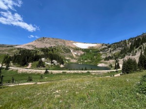
But it was amazing to see the last hill without a single patch of snow. In July! We drove up it, and no one had a problem with it. That meant we were soon at the end of the trail at Yankee Doodle Lake. Jenny Creek has always been one of our favorite trails, and it remains a favorite. What a great day!

bridge
closed_spurs
colorful
creek_crossing_part_1
creek_crossing_part_2
creek_crossing_part_3
creek_crossing_part_4
early_spur_climb
little_creek
monica_on_the_trail
old_cabin
repaired_crossing
restoration_area
roger_at_the_creek_crossing
roger_chopping
ski_sign
spur_at_the_creek_crossing
spur_intersection
spur_rocks_part_1
spur_rocks_part_2
spur_sign
start_of_the_trail
surrounded
through_trees
trailhead_signs_1
trailhead_signs_2
walt_and_roger_with_a_dead_tree
walt_and_roger
walt_at_the_creek_crossing_part_1
walt_at_the_creek_crossing_part_2
walt_at_the_creek_crossing_part_3
walt_in_scenery

Reports from Other Days: 7

Use the arrows or dots to flip through the previews of the other reports for Jenny Creek. Click one of them to read more and see all of the photos from that day.

August 1, 2015

Led by Monica I.
We were up in that area of Colorado to check out Jenny Creek. The trail has changed many times over the years, largely do to the erosion from the creek. It was always a good time, driving along the creek bed and popping in and out of the water. But…
»
  • 1
  • 2
  • 3
  • 4
  • 5
  • 6
  • 7
Join Us!
If you aren’t a Member or Subscriber, you can’t see all of the content on this site. Get membership information to see why this site is best when you join and log in

Information for Subscribers

When you log in you’ll see more information here:

  • Recent Community Forum posts
  • Recent polls
  • Upcoming Events you can attend
  • Links to online users

© 2000-2022 · TrailDamage.com · Terms and Conditions · About · Contact
Trail information is only accurate on the date posted. Trails may have changed or closed since that date. Use this information for historical purposes only.
Contact the Forest Service or Bureau of Land Management for up-to-date trail information.

/* ----------------------------------------- */ /* View slug: reports-other-reports-for-same-trail-slider - start */ /* ----------------------------------------- */ /* place the prev/next controls on the sides */ .td-transition-controls .wpv-filter-next-link, .td-transition-controls .wpv-filter-previous-link { border: none; font-size: 300%; position: absolute; top: 70px; } .td-transition-controls .wpv-filter-previous-link { left: 0; } .td-transition-controls .wpv-filter-next-link { right: 0; } /* center the page selector horizonatally */ .td-transition-controls ul.wpv_pagination_dots { text-align: center; margin-top: 10px; } /* center the page selector horizonatally */ .td-transition-controls ul.wpv_pagination_dots li.wpv_pagination_dots_item, .td-transition-controls .wpv_pagination_dots li a { display: inline-block; float: none; } /* remove the default styles */ .td-transition-controls .wpv_pagination_dots li a { text-decoration: none; border-bottom: none; } .td-slider-container { padding: 0 25px; margin-bottom: 20px; position: relative; width:100%; display:table; } .td-slides { position: relative; } .td-slides-image { float:left; display:table-cell; } .td-slides-image img { border:1px solid #c0c0c0; } .td-slides-content { padding:4px 4px 4px 10px; border-top:1px solid #c0c0c0; border-right:1px solid #c0c0c0; border-bottom:1px solid #c0c0c0; display:table-cell; height:227px; overflow:hidden; } .td-slides-content h3 { margin-top:8px; } .td-slides-leader { font-size:smaller; margin-top:4px; } /* ----------------------------------------- */ /* View slug: reports-other-reports-for-same-trail-slider - end */ /* ----------------------------------------- */
/* ----------------------------------------- */ /* Content Template: Template for a Single Report - start */ /* ----------------------------------------- */ .entry-header { display:none; } .entry-content h1 { margin-top:16px; padding-top:0; } h1 a { color:#222; } h1 a:hover { color:#666; } p.entry-meta { font-size:small; } #report-body-spacer { clear:both; width:100%; height:20px; } #addtoany-bar { margin-bottom:2em; text-align:center; } .category-reports .post-info .author, .post-info .date { display: none; } .addthis_recommended_horizontal { text-align:center !important; } /* ----------------------------------------- */ /* Content Template: Template for a Single Report - end */ /* ----------------------------------------- */ /* ----------------------------------------- */ /* Content Template: Loop item in REPORTS Runners - start */ /* ----------------------------------------- */ #runners-container { width:100%; clear:both; } .runner { border:1px solid #c0c0c0; margin:0 6px 6px 0; float:left; width:49%; height:81px; } .runner-image { float: left; } .runner-image img { margin:2px 10px 0 2px; height:75px; width:75px; } .runner-name { text-transform:uppercase; } .runner-name a { color:#222; } .runner-name a:hover { color:#666; } .runner-vehicle { font-size:small; } @media only screen and (max-width: 768px) { .runner { width:100%; } } /* ----------------------------------------- */ /* Content Template: Loop item in REPORTS Runners - end */ /* ----------------------------------------- */