TrailDamage.com

Photos, videos and information about 4x4 trails in Colorado and Utah

  • Trails
    • Colorado
    • Utah
  • Reports
    • Featured Photos
    • Featured Videos
    • Reports Calendar
  • Members
  • Search
  • Trail Damage Winners
  • FAQ
  • Community
  • Upcoming Events
  • Membership
  • Log In
  • Facebook
  • Instagram
  • RSS
  • Twitter
  • YouTube

Ironclads 061014

October 14, 2006 by Monica

Ironclads

Trail Run on October 14, 2006
Report and photos by Monica I., Trail Leader
View trail information for Ironclads

Monica I.
Red 2010 Jeep Wrangler Rubicon
Don W.
Silver 2005 Jeep Wrangler Rubicon
Micheal S.
Maroon 1988 Jeep Cherokee
Cheryl W.
Orange 2006 Jeep Wrangler Unlimited Rubicon

We left Dave at the trailhead because he had to head for home, then we headed up. We went the wrong way at first, but we soon realized our mistake. When we found the brown Forest Service sign for 216 we knew we were headed in the right direction.

The trail started off pretty mellow except for the ledge near the start. It wasn't too big, but the dirt at the bottom was pretty loose.

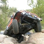
We followed the signs and soon came to the intersection at the bottom of the loop. We started up the right side and it immediately got interesting. It was loose, steep and rocky. It was fun to climb. Luckily we didn't see anyone coming down.

When we got to the intersection with 216A we took that up. The Play Hill was instantly a blast. Monica started up it and didn't think a section next to a tree was going to be difficult, but she soon found out that there was more to it than it seemed. She had to work on it a bit, but then finally got through it.

It was really loose and really steep but everyone had a good time on it. Cheryl came next and thought she was through it, then she was surprised to find out that it wasn't going to be that easy. It only took a little bit more momentum.

Micheal made it look pretty easy, but he still had to take a couple runs at it to get through.

Don tried it first without his lockers but it was proving to be a lot more work than he thought it would be. He turned his lockers on and bounced up it.

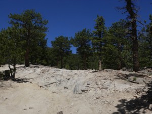
When we got to the top of Play Hill there was a huge rock that needed climbing. A few of us climbed to the top while a few stayed to wait at the bottom. It was a good climb but it didn't offer the amazing views we thought it would.

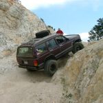
We kept going until we got to Window. It looked pretty easy, and Monica tried it first. After a couple bounces she decided it wasn't worth risking breakages so she backed out of it and took the bypass up.

Cheryl got in it next, starting off in the middle of it. She instantly slid sideways to the right and found herself really stuck in it. She couldn't back down because now a big tree was behind her, and the big rock was in front of her. The tree roots were slippery, and she couldn't get through it. She finally went at it a little sideways, and that worked.

Micheal tried it next and he got close to the tree on the left. That proved to be the line through it, and he bounced his way up. It took a few tries but eventually he got right through it.

Don tried it first without lockers, but again it just proved to be too much. He took Micheal's line on the left and bounced right up it, to cheers from the rest of us. Then he got stuck at the top and everyone stopped cheering. He backed up a bit and gave it some momentum and he got cheers again when he got through it.

We should have stopped there and walked up, but we didn't realize the trail just ended. The views from the top were nice, and you could see for a long way out past the foothills. We snapped a few pictures, then headed down.

We all went down through Window, but of course it was easy in that direction.

Play Hill was also easy because we took the line furthest to the left. It was steep, but not a big deal.

The other half of the loop on 216 was rocky but much wider than the half of the loop on the way up. It didn't take us long to finish the loop and then the rest of the trail.

When we got to the bottom we finished up Bunce School Road and headed for dinner. This is a great, fun trail.

aspen_leaves
big_ledge_near_the_start
bottom_of_play_hill
bottom_of_the_loop
bumpy_climb
cheryl_at_the_top
cheryl_through_window_part_1
cheryl_through_window_part_2
cheryl_through_window_part_3
cheryl_through_window_part_4
cheryl_through_window_part_5
cheryl_up_play_hill_part_1
cheryl_up_play_hill_part_2
cheryl_up_play_hill_part_3
cheryl_up_play_hill_part_4
cheryl_up_play_hill_part_5
climbing
cool_log
don_at_the_top
don_muddy_part_1
don_muddy_part_2
don_through_window
don_up_play_hill_part_1
don_up_play_hill_part_2
don_up_play_hill_part_3
don_up_play_hill_part_4
don_up_play_hill_part_5
don_up_play_hill_part_6
follow_signs_for_216
mellow_section
micheal_and_don_up_play_hill
micheal_at_the_top
micheal_through_window
micheal_up_play_hill_part_1
micheal_up_play_hill_part_2
micheal_up_play_hill_part_3
micheal_up_play_hill_part_4
micheal_up_play_hill_part_5
micheal_up_play_hill_part_6
micheal_up_play_hill_part_7
monica_at_the_top
near_the_top
rocky_downhill
sign_for_216a
smooth_trail
trail_near_the_top
tree_roots
view_at_the_top_part_1
view_at_the_top_part_2
view_at_the_top_part_3

Reports from Other Days: 4

Use the arrows or dots to flip through the previews of the other reports for Ironclads. Click one of them to read more and see all of the photos from that day.

June 12, 2021

Led by Monica I.
We were happy to see the Ironclads trail open, as other trails in the area were still closed for the winter.  After a brief section of Bunce School Road, we turned onto Ironclads.  There were lots of people out on the trails, and everyone seemed happy and ready for a…
»
  • 1
  • 2
  • 3
  • 4
Join Us!
If you aren’t a Member or Subscriber, you can’t see all of the content on this site. Get membership information to see why this site is best when you join and log in

Information for Subscribers

When you log in you’ll see more information here:

  • Recent Community Forum posts
  • Recent polls
  • Upcoming Events you can attend
  • Links to online users

© 2000-2022 · TrailDamage.com · Terms and Conditions · About · Contact
Trail information is only accurate on the date posted. Trails may have changed or closed since that date. Use this information for historical purposes only.
Contact the Forest Service or Bureau of Land Management for up-to-date trail information.

/* ----------------------------------------- */ /* View slug: reports-other-reports-for-same-trail-slider - start */ /* ----------------------------------------- */ /* place the prev/next controls on the sides */ .td-transition-controls .wpv-filter-next-link, .td-transition-controls .wpv-filter-previous-link { border: none; font-size: 300%; position: absolute; top: 70px; } .td-transition-controls .wpv-filter-previous-link { left: 0; } .td-transition-controls .wpv-filter-next-link { right: 0; } /* center the page selector horizonatally */ .td-transition-controls ul.wpv_pagination_dots { text-align: center; margin-top: 10px; } /* center the page selector horizonatally */ .td-transition-controls ul.wpv_pagination_dots li.wpv_pagination_dots_item, .td-transition-controls .wpv_pagination_dots li a { display: inline-block; float: none; } /* remove the default styles */ .td-transition-controls .wpv_pagination_dots li a { text-decoration: none; border-bottom: none; } .td-slider-container { padding: 0 25px; margin-bottom: 20px; position: relative; width:100%; display:table; } .td-slides { position: relative; } .td-slides-image { float:left; display:table-cell; } .td-slides-image img { border:1px solid #c0c0c0; } .td-slides-content { padding:4px 4px 4px 10px; border-top:1px solid #c0c0c0; border-right:1px solid #c0c0c0; border-bottom:1px solid #c0c0c0; display:table-cell; height:227px; overflow:hidden; } .td-slides-content h3 { margin-top:8px; } .td-slides-leader { font-size:smaller; margin-top:4px; } /* ----------------------------------------- */ /* View slug: reports-other-reports-for-same-trail-slider - end */ /* ----------------------------------------- */
/* ----------------------------------------- */ /* Content Template: Template for a Single Report - start */ /* ----------------------------------------- */ .entry-header { display:none; } .entry-content h1 { margin-top:16px; padding-top:0; } h1 a { color:#222; } h1 a:hover { color:#666; } p.entry-meta { font-size:small; } #report-body-spacer { clear:both; width:100%; height:20px; } #addtoany-bar { margin-bottom:2em; text-align:center; } .category-reports .post-info .author, .post-info .date { display: none; } .addthis_recommended_horizontal { text-align:center !important; } /* ----------------------------------------- */ /* Content Template: Template for a Single Report - end */ /* ----------------------------------------- */ /* ----------------------------------------- */ /* Content Template: Loop item in REPORTS Runners - start */ /* ----------------------------------------- */ #runners-container { width:100%; clear:both; } .runner { border:1px solid #c0c0c0; margin:0 6px 6px 0; float:left; width:49%; height:81px; } .runner-image { float: left; } .runner-image img { margin:2px 10px 0 2px; height:75px; width:75px; } .runner-name { text-transform:uppercase; } .runner-name a { color:#222; } .runner-name a:hover { color:#666; } .runner-vehicle { font-size:small; } @media only screen and (max-width: 768px) { .runner { width:100%; } } /* ----------------------------------------- */ /* Content Template: Loop item in REPORTS Runners - end */ /* ----------------------------------------- */