TrailDamage.com

Photos, videos and information about 4x4 trails in Colorado and Utah

  • Trails
    • Colorado
    • Utah
  • Reports
    • Featured Photos
    • Featured Videos
    • Reports Calendar
  • Members
  • Search
  • Trail Damage Winners
  • FAQ
  • Community
  • Upcoming Events
  • Membership
  • Log In
  • Facebook
  • Instagram
  • RSS
  • Twitter
  • YouTube

Imogene Pass 080829

August 29, 2008 by Monica

Imogene Pass

Trail Run on August 29, 2008
Report and photos by Monica I., Trail Leader
View trail information for Imogene Pass

Walt S.
Gray 2018 Jeep Wrangler Unlimited Rubicon
Michael M.
Black 2006 Jeep Wrangler Unlimited Rubicon
Don W.
Silver 2005 Jeep Wrangler Rubicon

You can't do Black Bear Pass without completing the loop with Imogene Pass, and that's exactly what we did. It was easy to find the trailhead with a GPS, which was a nice change from the last time when we didn't have auto-routing. We even enjoyed our drive through Telluride, marveling at the houses and how much they must cost.

The trail runs along people's property, and some driveways and parking areas are there. It would be pretty cool to have "Imogene Pass" as your address. We were definitely jealous.

The views of Black Bear Pass from the beginning of the trail are always amazing. We couldn't believe we'd come down those switchbacks. They look so much worse from far away. Of course, being able to see Ingram Falls and Bridal Veil Falls along with the powerhouse was a bonus.

There are so many mines along this stretch of the trail. We were on the CB the whole time, talking about them. Even the little tunnel was cool. We also noticed that a lot of the aspen trees had been knocked down, maybe by heavy snows the winter before.

It didn't take long to get to Tomboy and Savage Basin. The weather was still nice, and we spent a lot of time exploring. We even saw a tour bus come through, going the other way. That was good timing.

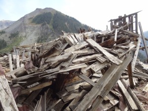
Tomboy seems different than other mining sites. A lot of the equipment and buildings are newer than the same at other sites, and it seems more like trash at times. For instance, a rusty barrel sitting in a mountain stream that is only 60 years old may seem like garbage, while a set of gears from a mine from 100 years ago seems more historical and scenic. At what point will rusty barrels at Tomboy look scenic?

We probably enjoyed Tomboy the least of all of the mining sites we'd see over the course of our week, though it was interesting. It was such a big site, and it made you wish you could see it as it was, in its prime. We even saw a deer there, by itself, which seemed odd.

We worked our way up the talus to the pass, and the views were incredible. Sometimes it felt like we were in an airplane, we were so high in elevation.

Just after the pass, we went up to the overlook. The last time we were here, it was raining and the overlook was treacherous and slick. This time, it was an easy drive. Though it would also be pretty easy to drive right off the side, so we were especially careful.

It was windy and getting pretty chilly, but we all took time to check out the scenery. You could see for miles in almost every direction. Going up to the overlook was definitely worth it.

The descent was pretty quick. We drove around the loop near the Hidden Treasure Mine, but we didn't get out. The sun was going down, and we still had a few miles to go.

At the sign for Richmond Basin, we took the spur to go see the waterfall. The sun was on its way, but there was still enough light. Michael and Don both went off exploring, finding a place to cross that wasn't too slick or muddy. The rest of us explored the immediate area.

We put in windows and put up soft tops at this point, because it was getting chilly. We enjoyed the way out, and we all had fun in the last water crossing just before the trail's end.

We discussed going up to Yankee Boy Basin or Governor Basin, but the sun was almost down. We were done for the day. That meant that we got to see Camp Bird Road in a little bit of daylight, and we were in Ouray in time for dinner. It was a great day!

almost_to_the_pass
approaching_tomboy
big_view
black_bear_pass_switchbacks
boilers
cimarron_mine
county_road_sign
creek_crossing
deer_part_1
deer_part_2
descending
don_and_michael_at_the_waterfall
down_from_the_overlook
early_trail
green_trail
hidden_treasure_mine_part_1
hidden_treasure_mine_part_2
hidden_treasure_mine_part_3
hidden_treasure_mine_part_4
hidden_treasure_mine_part_5
hidden_treasure_mine_part_6
hill_at_hidden_treasure_mine
imogene_creek
imogene_pass_ahead
imogene_pass_sign
jeep_shadow
leftovers
michael_and_walt_climbing
mining
old_cabin
optional_water_crossing
overlook_sign
overlook
richmond_basin_sign
ridge
start_of_the_trail
stripes
supported_trail
telluride_part_1
telluride_part_2
telluride_peak
tomboy_part_1
tomboy_part_2
tomboy_part_3
tomboy_part_4
tomboy_part_5
tomboy_part_6
tomboy_part_7
tomboy_part_8
tomboy_part_9
tomboy_sign_1
tomboy_sign_2
tomboy_sign_3
trail_ahead
trail_in_the_rock
trailhead_signs_1
trailhead_signs_2
trailhead_signs_3
tunnel
view_from_the_overlook_part_1
view_from_the_overlook_part_2
view_from_the_overlook_part_3
view_from_the_overlook_part_4
view_from_the_overlook_part_5
view_from_the_overlook_part_6
view_from_the_pass_part_1
view_from_the_pass_part_2
waterfall

Reports from Other Days: 4

Use the arrows or dots to flip through the previews of the other reports for Imogene Pass. Click one of them to read more and see all of the photos from that day.

September 8, 2017

Led by Monica I.
We had a blast on Black Bear Pass and a really nice lunch in Telluride at a park, and we made it across town to start Imogene Pass.  We immediately saw signs noting the road was closed, but then found out from someone coming the other way that the trail…
« »
  • 1
  • 2
  • 3
  • 4
Join Us!
If you aren’t a Member or Subscriber, you can’t see all of the content on this site. Get membership information to see why this site is best when you join and log in

Information for Subscribers

When you log in you’ll see more information here:

  • Recent Community Forum posts
  • Recent polls
  • Upcoming Events you can attend
  • Links to online users

© 2000-2022 · TrailDamage.com · Terms and Conditions · About · Contact
Trail information is only accurate on the date posted. Trails may have changed or closed since that date. Use this information for historical purposes only.
Contact the Forest Service or Bureau of Land Management for up-to-date trail information.

/* ----------------------------------------- */ /* View slug: reports-other-reports-for-same-trail-slider - start */ /* ----------------------------------------- */ /* place the prev/next controls on the sides */ .td-transition-controls .wpv-filter-next-link, .td-transition-controls .wpv-filter-previous-link { border: none; font-size: 300%; position: absolute; top: 70px; } .td-transition-controls .wpv-filter-previous-link { left: 0; } .td-transition-controls .wpv-filter-next-link { right: 0; } /* center the page selector horizonatally */ .td-transition-controls ul.wpv_pagination_dots { text-align: center; margin-top: 10px; } /* center the page selector horizonatally */ .td-transition-controls ul.wpv_pagination_dots li.wpv_pagination_dots_item, .td-transition-controls .wpv_pagination_dots li a { display: inline-block; float: none; } /* remove the default styles */ .td-transition-controls .wpv_pagination_dots li a { text-decoration: none; border-bottom: none; } .td-slider-container { padding: 0 25px; margin-bottom: 20px; position: relative; width:100%; display:table; } .td-slides { position: relative; } .td-slides-image { float:left; display:table-cell; } .td-slides-image img { border:1px solid #c0c0c0; } .td-slides-content { padding:4px 4px 4px 10px; border-top:1px solid #c0c0c0; border-right:1px solid #c0c0c0; border-bottom:1px solid #c0c0c0; display:table-cell; height:227px; overflow:hidden; } .td-slides-content h3 { margin-top:8px; } .td-slides-leader { font-size:smaller; margin-top:4px; } /* ----------------------------------------- */ /* View slug: reports-other-reports-for-same-trail-slider - end */ /* ----------------------------------------- */
/* ----------------------------------------- */ /* Content Template: Template for a Single Report - start */ /* ----------------------------------------- */ .entry-header { display:none; } .entry-content h1 { margin-top:16px; padding-top:0; } h1 a { color:#222; } h1 a:hover { color:#666; } p.entry-meta { font-size:small; } #report-body-spacer { clear:both; width:100%; height:20px; } #addtoany-bar { margin-bottom:2em; text-align:center; } .category-reports .post-info .author, .post-info .date { display: none; } .addthis_recommended_horizontal { text-align:center !important; } /* ----------------------------------------- */ /* Content Template: Template for a Single Report - end */ /* ----------------------------------------- */ /* ----------------------------------------- */ /* Content Template: Loop item in REPORTS Runners - start */ /* ----------------------------------------- */ #runners-container { width:100%; clear:both; } .runner { border:1px solid #c0c0c0; margin:0 6px 6px 0; float:left; width:49%; height:81px; } .runner-image { float: left; } .runner-image img { margin:2px 10px 0 2px; height:75px; width:75px; } .runner-name { text-transform:uppercase; } .runner-name a { color:#222; } .runner-name a:hover { color:#666; } .runner-vehicle { font-size:small; } @media only screen and (max-width: 768px) { .runner { width:100%; } } /* ----------------------------------------- */ /* Content Template: Loop item in REPORTS Runners - end */ /* ----------------------------------------- */