TrailDamage.com

Photos, videos and information about 4x4 trails in Colorado and Utah

  • Trails
    • Colorado
    • Utah
  • Reports
    • Featured Photos
    • Featured Videos
    • Reports Calendar
  • Members
  • Search
  • Trail Damage Winners
  • FAQ
  • Community
  • Upcoming Events
  • Membership
  • Log In
  • Facebook
  • Instagram
  • RSS
  • Twitter
  • YouTube

Horsethief Point 121020

October 20, 2012 by Monica

Horsethief Point

Trail Run on October 20, 2012
Report and photos by Monica I., Trail Leader
View trail information for Horsethief Point

Roger R.
Gray 2021 Jeep Wrangler Rubicon 4xe
Walt S.
Gray 2022 Jeep Wrangler Unlimited Rubicon 392
Monica I.
Red 2010 Jeep Wrangler Rubicon
Bill S.
Yellow 2020 Jeep Wrangler Rubicon
Ben P.
Green 2012 Jeep Wrangler Unlimited Rubicon

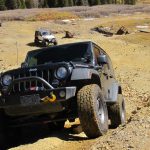
We were quickly running out of daylight so we'd only have time for one more trail. We decided to do a new one, so we popped back onto the pavement for a short distance until we found the trailhead for Horsethief Point. It wasn't marked, and it wasn't the same trailhead we found on maps, but it was nearby and we got lucky. It started out as an easy road and we thought it would be wide and easy the whole way. It shouldn't take long, right? Yeah, right.

Getting to the first spur was easy enough, with a wide and mellow trail to take us there. We spotted big RVs at the intersection, so they had come from the Mineral Bottom trail to get there. We passed by their campsite and continued along the trail.

We cruised along for a while, and then stopped to stretch our legs for a bit. That's when a big truck passed us, coming up from the other direction. We had been following his all-terrain tire tracks, so we figured the rest of the trail would be easy. That just makes sense, right?

After discovering a slab of slickrock that sounded disturbingly hollow underneath when you hit it with a rock, we played with that for a while before moving on. We came to a "Y" intersection that wasn't on the maps. Our trail took the rightmost part of the "Y" while our all-terrain tracks took the leftmost portion. We didn't know where the truck had gone earlier and we wanted to see Horsethief Point, so we took the rightmost option.

At this point, the only tracks in front of us for the rest of the day would be one set of ATV tracks. They never turned around and there was only one set, so we knew that there was another way out. It was most likely the second spur we found on the map. When we got to that spur, our ATV tracks took it even though it was very faint. We'd come back to it, and we were happy it existed. With only one set of tracks on it, it surely went through to Mineral Bottom.

We continued along to the point and the trail had no tracks on it at all. It was always an open trail with trees off in the distance, but then there was a very short section of trail that was overgrown with tamerisk and other brush. It was a tight fit and the trail was narrow, but we all got through. Roger noticed that it was an old earthen dam that used to hold back the water in the wash. It made us all wonder about the horse thieves and how they lived.

We followed the trail until we lost track of it, and then we got out to walk to the edge. It seemed that the edge along The Big Draw was closest, but when we walked out there we couldn't get anywhere near the edge without a lot of effort. We turned our attention to the actual point instead.

The rock at the end wasn't actually attached to the mesa, so you had to walk over a deep crack to get on the point. Almost everyone dared to do it. When you got to the edge you could see the Taylor Canyon trail below, but no water. We spent a long time wandering around the edges and checking things out.

On the long walk back to the car we found the trail, so it actually continued farther than where we were. When we got back to the Jeeps we drove out to the turnaround and back, just to say we'd been to the end. The trail had been right in front of Monica's Jeep but no one saw it until we were on the way back.

When we got to the turn to go to Mineral Bottom it was nice to see our familiar ATV tracks again. The sunlight was fading away as we followed them through pastures and around rock outcroppings. It wasn't a well-used trail but it was fine as we worked our way north. After winding around a lot we finally connected with the Mineral Bottom trail.

In the fading light, we put Jeep tops back on and doors back in. It had been a warm day but the chilly desert nights were in place already. We were thinking about taking Long Canyon out, but there wasn't much point in the darkness. We took highway 313 out instead, and it was a quick and easy trip. We hit Pizza Hut for dinner and the Brewery for beers, and then it was time to head back to the hotel. It was a really great day in Moab!

ben_and_bill
bigger_trees
bumpy_spot
canyon_below
crack_part_1
crack_part_2
crack_part_3
curves_and_clouds
desert_at_dusk
drop_off
dry_canyon
easy_trail
horsethief_point_view_part_1
horsethief_point_view_part_2
horsethief_point_view_part_3
horsethief_point_view_part_4
late_day_shadows
little_climb
miles_away
on_horsethief_point
open_space
out_of_the_wash
red_dirt
rock_layers
slickrock_patches
start_of_the_trail
sunset
through_brush
walt_wandering_around
Join Us!
If you aren’t a Member or Subscriber, you can’t see all of the content on this site. Get membership information to see why this site is best when you join and log in

Information for Subscribers

When you log in you’ll see more information here:

  • Recent Community Forum posts
  • Recent polls
  • Upcoming Events you can attend
  • Links to online users

© 2000-2022 · TrailDamage.com · Terms and Conditions · About · Contact
Trail information is only accurate on the date posted. Trails may have changed or closed since that date. Use this information for historical purposes only.
Contact the Forest Service or Bureau of Land Management for up-to-date trail information.

/* ----------------------------------------- */ /* View slug: reports-other-reports-for-same-trail-slider - start */ /* ----------------------------------------- */ /* place the prev/next controls on the sides */ .td-transition-controls .wpv-filter-next-link, .td-transition-controls .wpv-filter-previous-link { border: none; font-size: 300%; position: absolute; top: 70px; } .td-transition-controls .wpv-filter-previous-link { left: 0; } .td-transition-controls .wpv-filter-next-link { right: 0; } /* center the page selector horizonatally */ .td-transition-controls ul.wpv_pagination_dots { text-align: center; margin-top: 10px; } /* center the page selector horizonatally */ .td-transition-controls ul.wpv_pagination_dots li.wpv_pagination_dots_item, .td-transition-controls .wpv_pagination_dots li a { display: inline-block; float: none; } /* remove the default styles */ .td-transition-controls .wpv_pagination_dots li a { text-decoration: none; border-bottom: none; } .td-slider-container { padding: 0 25px; margin-bottom: 20px; position: relative; width:100%; display:table; } .td-slides { position: relative; } .td-slides-image { float:left; display:table-cell; } .td-slides-image img { border:1px solid #c0c0c0; } .td-slides-content { padding:4px 4px 4px 10px; border-top:1px solid #c0c0c0; border-right:1px solid #c0c0c0; border-bottom:1px solid #c0c0c0; display:table-cell; height:227px; overflow:hidden; } .td-slides-content h3 { margin-top:8px; } .td-slides-leader { font-size:smaller; margin-top:4px; } /* ----------------------------------------- */ /* View slug: reports-other-reports-for-same-trail-slider - end */ /* ----------------------------------------- */
/* ----------------------------------------- */ /* Content Template: Template for a Single Report - start */ /* ----------------------------------------- */ .entry-header { display:none; } .entry-content h1 { margin-top:16px; padding-top:0; } h1 a { color:#222; } h1 a:hover { color:#666; } p.entry-meta { font-size:small; } #report-body-spacer { clear:both; width:100%; height:20px; } #addtoany-bar { margin-bottom:2em; text-align:center; } .category-reports .post-info .author, .post-info .date { display: none; } .addthis_recommended_horizontal { text-align:center !important; } /* ----------------------------------------- */ /* Content Template: Template for a Single Report - end */ /* ----------------------------------------- */ /* ----------------------------------------- */ /* Content Template: Loop item in REPORTS Runners - start */ /* ----------------------------------------- */ #runners-container { width:100%; clear:both; } .runner { border:1px solid #c0c0c0; margin:0 6px 6px 0; float:left; width:49%; height:81px; } .runner-image { float: left; } .runner-image img { margin:2px 10px 0 2px; height:75px; width:75px; } .runner-name { text-transform:uppercase; } .runner-name a { color:#222; } .runner-name a:hover { color:#666; } .runner-vehicle { font-size:small; } @media only screen and (max-width: 768px) { .runner { width:100%; } } /* ----------------------------------------- */ /* Content Template: Loop item in REPORTS Runners - end */ /* ----------------------------------------- */