TrailDamage.com

Photos, videos and information about 4x4 trails in Colorado and Utah

  • Trails
    • Colorado
    • Utah
  • Reports
    • Featured Photos
    • Featured Videos
    • Reports Calendar
  • Members
  • Search
  • Trail Damage Winners
  • FAQ
  • Community
  • Upcoming Events
  • Membership
  • Log In
  • Facebook
  • Instagram
  • RSS
  • Twitter
  • YouTube

High Trail 130706

July 6, 2013 by Monica

High Trail

Trail Run on July 6, 2013
Report and photos by Monica I., Trail Leader
View trail information for High Trail

Monica I.
Red 2010 Jeep Wrangler Rubicon
Bill S.
Yellow 2020 Jeep Wrangler Rubicon
Ben P.
Green 2012 Jeep Wrangler Unlimited Rubicon

We just came off of the Piney Ridge trail and we were heading for the pavement when we got to the trailhead for High Trail. If we turned right and stayed on the Sheephorn Creek trail (forest service road 402) we'd stay on a relatively easy trail until we hit Trough Road. However, if we turned left there was a chance we'd end up on Trough Road or highway 131 via a much more interesting trail. The MVUM wasn't very clear and maps showed two ways out. We decided to risk it so we did the High Trail.

We kept going west and the trail got less and less defined. When we reached the "T" intersection it was pretty overgrown but you could tell people had been there recently. Ben went farther west but he could tell that wasn't a trail so he soon came back. Bill took forest service road 445 a bit to the north and he found a trail that saw some use so we followed him. There were freshly cut logs clearing deadwood from the trail, so we hoped that it would take us out to Trough Road.

It was pretty on the mesa and we enjoyed the trail. It looked like it was used by snowmobilers in the winter, too. We were happily working our way through the scenery when the trail ended at a fence and gate with a fresh chain and padlock on it. There were signs stating we couldn't cross, and a phone number for the sheriff's office. Monica called the number to see if we were missing another way out, but they didn't have maps of the area. They were pretty rude as they told us they couldn't help us, so the phone call was pointless. We turned around and headed back to the "T" intersection.

At that point, we talked about what to do. The southern part of the trail didn't look much more used as it climbed up the ridge. After a brief discussion we decided to go check it out, just in case it got us to the pavement.

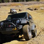
The hill climb was a blast, up slippery rocks in the trees. It looked like it was well used, too. We climbed up and over the ridge, and it was much lower where we were compared to what we'd seen earlier.

Once we started heading down High Trail Gulch the trail was more overgrown. It was always easy to find, though, and it was very fun in spots. It was rocky and muddy sometimes, and always bumpy. We worked our way downhill, and the trail ended again at a locked gate and fence. The trail used to continue at another spot, but there was a sign noting it was no longer a trail. We were about 1.2 miles from a main road, so it was a bit frustrating, especially because the sun was going down. There wasn't much we could do, though, so we headed back up the hill. It was a pretty fun hill climb, though.

We headed back to the trailhead and then out forest service road 402. It was completely dark by the time we got to Trough Road. We ended up back in Kremmling about 12 hours after we left it that morning, so it was a long day of wheeling. Ben aired up and headed for home.

Bill and Monica had planned to camp again and then do some more wheeling on Sunday. We discussed it, and we were both exhausted from two long days of wheeling with little sleep in between. It was already around 50 degrees, and neither one of us felt like heading back to a wet campsite. After a bit of discussion we decided we weren't wheeling the next day. Then we decided to head back to camp, pack up, and go home.

It was after midnight by the time we were leaving our newly emptied campsite, but it wasn't far back to Denver. That was the good part -- the trails were all fairly close to town. It was a long two days, but it was a great time. We'd be back to see the rest of the trails at some point. Good times in the mud!

aspens
big_view
bill_in_aspens
blue_sky
climbing
colorful
curve
early_trail
faint
flowers
layers
little-used_trail
meadow
muddy
near_the_intersection
northern_view
ridge
rocks
snag
southern_end
spur_carsonite
spur_on_a_spur
trail_with_a_view
trailhead_carsonite
trees_in_a_meadow
valley
Join Us!
If you aren’t a Member or Subscriber, you can’t see all of the content on this site. Get membership information to see why this site is best when you join and log in

Information for Subscribers

When you log in you’ll see more information here:

  • Recent Community Forum posts
  • Recent polls
  • Upcoming Events you can attend
  • Links to online users

© 2000-2022 · TrailDamage.com · Terms and Conditions · About · Contact
Trail information is only accurate on the date posted. Trails may have changed or closed since that date. Use this information for historical purposes only.
Contact the Forest Service or Bureau of Land Management for up-to-date trail information.

/* ----------------------------------------- */ /* View slug: reports-other-reports-for-same-trail-slider - start */ /* ----------------------------------------- */ /* place the prev/next controls on the sides */ .td-transition-controls .wpv-filter-next-link, .td-transition-controls .wpv-filter-previous-link { border: none; font-size: 300%; position: absolute; top: 70px; } .td-transition-controls .wpv-filter-previous-link { left: 0; } .td-transition-controls .wpv-filter-next-link { right: 0; } /* center the page selector horizonatally */ .td-transition-controls ul.wpv_pagination_dots { text-align: center; margin-top: 10px; } /* center the page selector horizonatally */ .td-transition-controls ul.wpv_pagination_dots li.wpv_pagination_dots_item, .td-transition-controls .wpv_pagination_dots li a { display: inline-block; float: none; } /* remove the default styles */ .td-transition-controls .wpv_pagination_dots li a { text-decoration: none; border-bottom: none; } .td-slider-container { padding: 0 25px; margin-bottom: 20px; position: relative; width:100%; display:table; } .td-slides { position: relative; } .td-slides-image { float:left; display:table-cell; } .td-slides-image img { border:1px solid #c0c0c0; } .td-slides-content { padding:4px 4px 4px 10px; border-top:1px solid #c0c0c0; border-right:1px solid #c0c0c0; border-bottom:1px solid #c0c0c0; display:table-cell; height:227px; overflow:hidden; } .td-slides-content h3 { margin-top:8px; } .td-slides-leader { font-size:smaller; margin-top:4px; } /* ----------------------------------------- */ /* View slug: reports-other-reports-for-same-trail-slider - end */ /* ----------------------------------------- */
/* ----------------------------------------- */ /* Content Template: Template for a Single Report - start */ /* ----------------------------------------- */ .entry-header { display:none; } .entry-content h1 { margin-top:16px; padding-top:0; } h1 a { color:#222; } h1 a:hover { color:#666; } p.entry-meta { font-size:small; } #report-body-spacer { clear:both; width:100%; height:20px; } #addtoany-bar { margin-bottom:2em; text-align:center; } .category-reports .post-info .author, .post-info .date { display: none; } .addthis_recommended_horizontal { text-align:center !important; } /* ----------------------------------------- */ /* Content Template: Template for a Single Report - end */ /* ----------------------------------------- */ /* ----------------------------------------- */ /* Content Template: Loop item in REPORTS Runners - start */ /* ----------------------------------------- */ #runners-container { width:100%; clear:both; } .runner { border:1px solid #c0c0c0; margin:0 6px 6px 0; float:left; width:49%; height:81px; } .runner-image { float: left; } .runner-image img { margin:2px 10px 0 2px; height:75px; width:75px; } .runner-name { text-transform:uppercase; } .runner-name a { color:#222; } .runner-name a:hover { color:#666; } .runner-vehicle { font-size:small; } @media only screen and (max-width: 768px) { .runner { width:100%; } } /* ----------------------------------------- */ /* Content Template: Loop item in REPORTS Runners - end */ /* ----------------------------------------- */