TrailDamage.com

Photos, videos and information about 4x4 trails in Colorado and Utah

  • Trails
    • Colorado
    • Utah
  • Reports
    • Featured Photos
    • Featured Videos
    • Reports Calendar
  • Members
  • Search
  • Trail Damage Winners
  • FAQ
  • Community
  • Upcoming Events
  • Membership
  • Log In
  • Facebook
  • Instagram
  • RSS
  • Twitter
  • YouTube

Galena Queen Mine 170909

September 9, 2017 by Monica

Galena Queen Mine

Trail Run on September 9, 2017
Report and photos by Monica I., Trail Leader
View trail information for Galena Queen Mine

Walt S.
Gray 2022 Jeep Wrangler Unlimited Rubicon 392
Monica I.
Red 2010 Jeep Wrangler Rubicon
Niko K.
Gray 2017 Jeep Wrangler Unlimited

This trail turned out to be one of the highlights of the day, with some amazing scenery, a few challenges, and a mine that was largely intact.  We really enjoyed this one.

It follows Prospect Gulch and passes the famous Henrietta Mine, and there is a place to stop below the Joe and John Mine where you can see some mining remnants.  You can also see quite a bit across the valley, but we didn't find a way over there.  We hung out at the Joe and John Mine for a little while before continuing on.

We decided to go up Red Mountain Number 3 first, so we skipped the big mine on the way up.  We climbed above timberline and through a few switchbacks, and it was cool to be climbing along the red slab of mountain.  When we got to the final switchback, it looked like the trail might end up ahead but Monica went farther anyway, just to check things out.  She got to the end to find that the trail was a little wider in a bowl where she'd need to turn around or back all the way back to the switchback.  She got out to plan her path and chat with the rest of the group about it.  In the end, she spotted while Walt turned her Jeep around, and then she headed back to the switchback.

The views at the switchback were amazing!  We could see places we'd been earlier, including the big overlook on Corkscrew Basin as well as the spur above Gold King Mine on Minnehaha Basin.  It was pretty cool, and we knew that Niko had drone footage he took on Corkscrew Basin that would show the switchback on Galena Queen Mine.  Very cool.

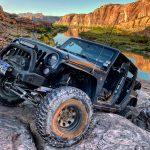
The views were awesome, but we wanted to check out the big mine so we headed down.  We were surprised to find the trail torn up just before the mine, making it a nice little challenge.  No one had any issues, and we were soon parked at the mine.

There is so much to see at the Galena Queen Mine because so much of it is still standing and in the original places.  We talked about how things must have worked and the pieces that were missing, and wondered what some things were for.  It was pretty cool, and the views from the open door were awe inspiring.

After a long time at the mine we finally headed back out, stopping on the way down to discuss the rest of our day.  We still had daylight left and it was Niko's last day, so we wanted to do one more trail before calling it a night and heading back to Ouray.  We went over to McMillan Peak to wrap up our long day of trails.

DSC02370
DSC02371
DSC02372
DSC02374
DSC02376
DSC02377
DSC02378
DSC02379
DSC02380
DSC02381
DSC02383
DSC02384
DSC02386
DSC02387
DSC02388
DSC02389
DSC02393
DSC02394
DSC02395
DSC02396
DSC02398
DSC02400
DSC02401
DSC02402
DSC02403
DSC02404
DSC02405
DSC02406
DSC02408
DSC02409
DSC02410
DSC02411
DSC02414
DSC02415
DSC02416
DSC02417
DSC02418
DSC02419
DSC02420
DSC02423
DSC02424
DSC02425
DSC02426
DSC02427
DSC02428
DSC02429
DSC02430
DSC02431
DSC02432
DSC02433
DSC02434
DSC02435
DSC02436
DSC02437
DSC02438
DSC02439
DSC02440
DSC02441
DSC02442
DSC02443
DSC02444
DSC02445
DSC02446
DSC02447
DSC02448
DSC02449
DSC02450
DSC02451
DSC02453
DSC02454
DSC02456
DSC02457
DSC02458
DSC02459
DSC02460
DSC02462
DSC02463
DSC02464
DSC02466
DSC02467
DSC02468
Join Us!
If you aren’t a Member or Subscriber, you can’t see all of the content on this site. Get membership information to see why this site is best when you join and log in

Information for Subscribers

When you log in you’ll see more information here:

  • Recent Community Forum posts
  • Recent polls
  • Upcoming Events you can attend
  • Links to online users

© 2000-2022 · TrailDamage.com · Terms and Conditions · About · Contact
Trail information is only accurate on the date posted. Trails may have changed or closed since that date. Use this information for historical purposes only.
Contact the Forest Service or Bureau of Land Management for up-to-date trail information.

/* ----------------------------------------- */ /* View slug: reports-other-reports-for-same-trail-slider - start */ /* ----------------------------------------- */ /* place the prev/next controls on the sides */ .td-transition-controls .wpv-filter-next-link, .td-transition-controls .wpv-filter-previous-link { border: none; font-size: 300%; position: absolute; top: 70px; } .td-transition-controls .wpv-filter-previous-link { left: 0; } .td-transition-controls .wpv-filter-next-link { right: 0; } /* center the page selector horizonatally */ .td-transition-controls ul.wpv_pagination_dots { text-align: center; margin-top: 10px; } /* center the page selector horizonatally */ .td-transition-controls ul.wpv_pagination_dots li.wpv_pagination_dots_item, .td-transition-controls .wpv_pagination_dots li a { display: inline-block; float: none; } /* remove the default styles */ .td-transition-controls .wpv_pagination_dots li a { text-decoration: none; border-bottom: none; } .td-slider-container { padding: 0 25px; margin-bottom: 20px; position: relative; width:100%; display:table; } .td-slides { position: relative; } .td-slides-image { float:left; display:table-cell; } .td-slides-image img { border:1px solid #c0c0c0; } .td-slides-content { padding:4px 4px 4px 10px; border-top:1px solid #c0c0c0; border-right:1px solid #c0c0c0; border-bottom:1px solid #c0c0c0; display:table-cell; height:227px; overflow:hidden; } .td-slides-content h3 { margin-top:8px; } .td-slides-leader { font-size:smaller; margin-top:4px; } /* ----------------------------------------- */ /* View slug: reports-other-reports-for-same-trail-slider - end */ /* ----------------------------------------- */
/* ----------------------------------------- */ /* Content Template: Template for a Single Report - start */ /* ----------------------------------------- */ .entry-header { display:none; } .entry-content h1 { margin-top:16px; padding-top:0; } h1 a { color:#222; } h1 a:hover { color:#666; } p.entry-meta { font-size:small; } #report-body-spacer { clear:both; width:100%; height:20px; } #addtoany-bar { margin-bottom:2em; text-align:center; } .category-reports .post-info .author, .post-info .date { display: none; } .addthis_recommended_horizontal { text-align:center !important; } /* ----------------------------------------- */ /* Content Template: Template for a Single Report - end */ /* ----------------------------------------- */ /* ----------------------------------------- */ /* Content Template: Loop item in REPORTS Runners - start */ /* ----------------------------------------- */ #runners-container { width:100%; clear:both; } .runner { border:1px solid #c0c0c0; margin:0 6px 6px 0; float:left; width:49%; height:81px; } .runner-image { float: left; } .runner-image img { margin:2px 10px 0 2px; height:75px; width:75px; } .runner-name { text-transform:uppercase; } .runner-name a { color:#222; } .runner-name a:hover { color:#666; } .runner-vehicle { font-size:small; } @media only screen and (max-width: 768px) { .runner { width:100%; } } /* ----------------------------------------- */ /* Content Template: Loop item in REPORTS Runners - end */ /* ----------------------------------------- */