TrailDamage.com

Photos, videos and information about 4x4 trails in Colorado and Utah

  • Trails
    • Colorado
    • Utah
  • Reports
    • Featured Photos
    • Featured Videos
    • Reports Calendar
  • Members
  • Search
  • Trail Damage Winners
  • FAQ
  • Community
  • Upcoming Events
  • Membership
  • Log In
  • Facebook
  • Instagram
  • RSS
  • Twitter
  • YouTube

Eagles Nest 130706

July 6, 2013 by Monica

Eagles Nest

Trail Run on July 6, 2013
Report and photos by Monica I., Trail Leader
View trail information for Eagles Nest

Bill S.
Yellow 2020 Jeep Wrangler Rubicon
Monica I.
Red 2010 Jeep Wrangler Rubicon
Ben P.
Green 2012 Jeep Wrangler Unlimited Rubicon

The Motor Vehicle Use Map (MVUM) for this area of the White River National Forest showed that the Eagles Nest trail ended at the Eagles Nest Wilderness Area. Other maps (even recent ones) showed that it went through to Chimney Rock, a feature on the Piney Ridge. We were hoping it went through, and we went to go check it out. We didn't get lucky this time.

We already did the first part of the Eagles Nest trail after finishing Elliott Ridge, so we actually did that part twice, in both directions. The trail got even more fun after we crossed into Eagle County. We headed downhill, and it was steep and fun. We saw groups of ATVs on the way, and everyone was obviously enjoying themselves. It was a great descent, and it would be even more fun on the way up. We'll remember that for our next time there.

When we got to the overlook it was lunch time, so we stopped. We got out the camp chairs and sat down to enjoy our meals while looking across the valley at Piney Ridge. We watched a big storm cloud hit the ridge and come right at us. It was only minutes before we were packing up our stuff and climbing back into our Jeeps. Unfortunately, we had to eat lunch in our vehicles while it poured rain.

There is still a bit of downhill trail after the overlook, and much of it is next to a big drop-off. The rain made everything muddy, and it was a thick and sticky mud. It dried really quickly, though, and we made our way down the switchbacks without too much trouble. When we got to the connector road we kept going, still hoping to drive to Chimney Rock.

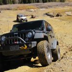
The trail was muddy and fun, and we didn't see anyone after we left the connector road. Apparently not many people take this trail all the way to the wilderness area. It was scenic and there were some fun, rocky spots along the way so we enjoyed it.

The trail was on the ridge above Sheephorn Creek, and we hoped to continue following a trail around to the other side. But then the trail ended at a kiosk and the border with the Eagles Nest Wilderness Area. We stopped to walk along the hiking trail a short distance, and it was definitely scenic.

The recent rain and all of the creeks and ponds in the area meant there were lots and lots of mosquitoes. There was no one camping in the big, buggy camping spots, and that wasn't surprising. We only hung out for a little bit before continuing back the way we came.

This time, we took the connector road and ended up at the kiosk on the Sheephorn Creek trail. We had options here, so we took a minute to figure out what to do. The big loop of the Sheephorn Creek trail looked inviting but it looked easy. Piney Ridge looked like more fun. We voted for fun, so we turned south to check out the ridge trail.

Eagles Nest was a good and scenic trail, but we weren't sure we'd do the final spur to the wilderness area again unless we had hiking plans. It was good to see it and explore, though, so the day was a good one. We passed near Slough Grass Lake and got to the trailhead for Piney Ridge quickly, and our day continued.

aspens_part_1
aspens_part_2
aspens_part_3
aspens_part_4
aspens_part_5
ben_at_lunch
ben_in_scenery
ben_on_the_trail
ben_taking_a_break
big_view
bill_in_the_sun
bill_muddy
bill_on_the_trail
bill_taking_a_break
break_time
bumpy
carsonite_sign
columbines
connector_kiosk_part_1
connector_kiosk_part_2
connector_kiosk_part_3
connector
creek
curve_and_clouds
curve_through_green
end_kiosk_part_1
end_kiosk_part_2
end_kiosk_part_3
end_kiosk_part_4
gate
gore_range_at_the_end
gore_range
green_and_brown
green_mountain_reservoir
layers
little_bumps
little-used_trail
lush
meadow
monica_taking_a_break
mountain_scene
out_of_the_trees
parked_at_the_end
piney_ridge_part_1
piney_ridge_part_2
rocky
ruts
scenic
shelf_road
sloped
soggy
spring_creek_sign
start_of_the_trail
storm_clouds
thick_trees
trail_ahead
trail_with_a_view
trailhead_sign
uphill_curve
view_at_the_end
wet_trail
Join Us!
If you aren’t a Member or Subscriber, you can’t see all of the content on this site. Get membership information to see why this site is best when you join and log in

Information for Subscribers

When you log in you’ll see more information here:

  • Recent Community Forum posts
  • Recent polls
  • Upcoming Events you can attend
  • Links to online users

© 2000-2022 · TrailDamage.com · Terms and Conditions · About · Contact
Trail information is only accurate on the date posted. Trails may have changed or closed since that date. Use this information for historical purposes only.
Contact the Forest Service or Bureau of Land Management for up-to-date trail information.

/* ----------------------------------------- */ /* View slug: reports-other-reports-for-same-trail-slider - start */ /* ----------------------------------------- */ /* place the prev/next controls on the sides */ .td-transition-controls .wpv-filter-next-link, .td-transition-controls .wpv-filter-previous-link { border: none; font-size: 300%; position: absolute; top: 70px; } .td-transition-controls .wpv-filter-previous-link { left: 0; } .td-transition-controls .wpv-filter-next-link { right: 0; } /* center the page selector horizonatally */ .td-transition-controls ul.wpv_pagination_dots { text-align: center; margin-top: 10px; } /* center the page selector horizonatally */ .td-transition-controls ul.wpv_pagination_dots li.wpv_pagination_dots_item, .td-transition-controls .wpv_pagination_dots li a { display: inline-block; float: none; } /* remove the default styles */ .td-transition-controls .wpv_pagination_dots li a { text-decoration: none; border-bottom: none; } .td-slider-container { padding: 0 25px; margin-bottom: 20px; position: relative; width:100%; display:table; } .td-slides { position: relative; } .td-slides-image { float:left; display:table-cell; } .td-slides-image img { border:1px solid #c0c0c0; } .td-slides-content { padding:4px 4px 4px 10px; border-top:1px solid #c0c0c0; border-right:1px solid #c0c0c0; border-bottom:1px solid #c0c0c0; display:table-cell; height:227px; overflow:hidden; } .td-slides-content h3 { margin-top:8px; } .td-slides-leader { font-size:smaller; margin-top:4px; } /* ----------------------------------------- */ /* View slug: reports-other-reports-for-same-trail-slider - end */ /* ----------------------------------------- */
/* ----------------------------------------- */ /* Content Template: Template for a Single Report - start */ /* ----------------------------------------- */ .entry-header { display:none; } .entry-content h1 { margin-top:16px; padding-top:0; } h1 a { color:#222; } h1 a:hover { color:#666; } p.entry-meta { font-size:small; } #report-body-spacer { clear:both; width:100%; height:20px; } #addtoany-bar { margin-bottom:2em; text-align:center; } .category-reports .post-info .author, .post-info .date { display: none; } .addthis_recommended_horizontal { text-align:center !important; } /* ----------------------------------------- */ /* Content Template: Template for a Single Report - end */ /* ----------------------------------------- */ /* ----------------------------------------- */ /* Content Template: Loop item in REPORTS Runners - start */ /* ----------------------------------------- */ #runners-container { width:100%; clear:both; } .runner { border:1px solid #c0c0c0; margin:0 6px 6px 0; float:left; width:49%; height:81px; } .runner-image { float: left; } .runner-image img { margin:2px 10px 0 2px; height:75px; width:75px; } .runner-name { text-transform:uppercase; } .runner-name a { color:#222; } .runner-name a:hover { color:#666; } .runner-vehicle { font-size:small; } @media only screen and (max-width: 768px) { .runner { width:100%; } } /* ----------------------------------------- */ /* Content Template: Loop item in REPORTS Runners - end */ /* ----------------------------------------- */