TrailDamage.com

Photos, videos and information about 4x4 trails in Colorado and Utah

  • Trails
    • Colorado
    • Utah
  • Reports
    • Featured Photos
    • Featured Videos
    • Reports Calendar
  • Members
  • Search
  • Trail Damage Winners
  • FAQ
  • Community
  • Upcoming Events
  • Membership
  • Log In
  • Facebook
  • Instagram
  • RSS
  • Twitter
  • YouTube

Cove Canyon 160514

May 14, 2016 by Monica

Cove Canyon

Trail Run on May 14, 2016
Report and photos by Monica I., Trail Leader
View trail information for Cove Canyon

Matt K.
White 2016 Jeep Wrangler Unlimited Rubicon
Walt S.
Gray 2022 Jeep Wrangler Unlimited Rubicon 392
Monica I.
Red 2010 Jeep Wrangler Rubicon
Ben P.
Green 2012 Jeep Wrangler Unlimited Rubicon
Frank N.
White 2010 Jeep Wrangler Unlimited Rubicon

We planned on spending two very long days in the Maze District of Canyonlands National Park, and this would be the first day. They had to be long days because the trails were all very long and it was a great distance to get into the Maze through Glen Canyon National Recreation Area. We met in Hanksville and headed south, all the way to Hite and the trailhead for Cove Canyon. The weather was perfect, and it promised to be a scenic and fun day.

We stopped at the kiosk to check out the map, and it looked like our plan would work. We'd do a few trails with Flint Trail in the middle, our real destination. It was still pretty early when we got started.

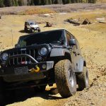
Cove Canyon was very scenic but very long as we wound our way around the cliff bases. We really liked the skinny and hugely tall mesa end that the trail took us around, but everything was pretty. We kept going, and soon got to the intersection with Lands End.

It had been an easy road so far, but the portion of the trail after Lands End wasn't as maintained. It was still pretty easy, though, until it headed into a wash. There were bits of the trail with river rocks in them, and some were fun to get over. The trail got more and more narrow, and soon we were at the base of a hill.

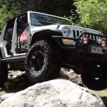
The hill wasn't maintained at all, and we weren't sure what to expect so Monica walked up it to check things out. The trail got wider after the first climb, so we all went up the hill. We made our way to the top of The Cove until we came to a flat and wide area where a few trails went in a few directions. It was a big crossroads.

We broke out the maps and noticed right away that we could spend some time exploring up on that mesa. After talking about it for a bit, we decided to head back down, saving that exploring for another day. We still had a long day ahead of us, after all.

Making our way back to the intersection with Lands End was fun, and it didn't take long. Cove Canyon was a great trail, but we were looking forward to getting farther into The Maze.

airing_down
alone
autumns_first_drive
ben_at_the_top
ben_parked
blue_flowers
bottom_of_the_hill
break_time
camp_area
clouds
colorful
cool_bluff
corral
cove_canyon_living
curve
desert_tree
distant_formation
dorit_on_a_break
first_bluff_end_part_1
first_bluff_end_part_2
first_bluff_end_part_3
first_bluff_end_part_4
flowers
formation
frank_at_the_top
frank_on_the_trail
frank_parked
jumbled
kiosk_part_1
kiosk_part_2
kiosk_part_3
kiosk_part_4
kiosk_part_5
less_maintained
little_bumps
little_rocks
long_road_ahead
matt_at_the_top
matt_on_the_trail
matt_parked
middle_finger_tower
monica_in_scenery
monica_on_the_trail
monica_parked
monica_up_the_hill
more-trees
morning_bluffs
narrow
near_the_end
newer_corral
old_fence
on_the_trail
open_space
patriotic
scenery
scenic_drive
start_of_the_trail
stripes
to_the_saddle
trying_to_get_out
walt_at_the_top
years_of_rockslides
Join Us!
If you aren’t a Member or Subscriber, you can’t see all of the content on this site. Get membership information to see why this site is best when you join and log in

Information for Subscribers

When you log in you’ll see more information here:

  • Recent Community Forum posts
  • Recent polls
  • Upcoming Events you can attend
  • Links to online users

© 2000-2022 · TrailDamage.com · Terms and Conditions · About · Contact
Trail information is only accurate on the date posted. Trails may have changed or closed since that date. Use this information for historical purposes only.
Contact the Forest Service or Bureau of Land Management for up-to-date trail information.

/* ----------------------------------------- */ /* View slug: reports-other-reports-for-same-trail-slider - start */ /* ----------------------------------------- */ /* place the prev/next controls on the sides */ .td-transition-controls .wpv-filter-next-link, .td-transition-controls .wpv-filter-previous-link { border: none; font-size: 300%; position: absolute; top: 70px; } .td-transition-controls .wpv-filter-previous-link { left: 0; } .td-transition-controls .wpv-filter-next-link { right: 0; } /* center the page selector horizonatally */ .td-transition-controls ul.wpv_pagination_dots { text-align: center; margin-top: 10px; } /* center the page selector horizonatally */ .td-transition-controls ul.wpv_pagination_dots li.wpv_pagination_dots_item, .td-transition-controls .wpv_pagination_dots li a { display: inline-block; float: none; } /* remove the default styles */ .td-transition-controls .wpv_pagination_dots li a { text-decoration: none; border-bottom: none; } .td-slider-container { padding: 0 25px; margin-bottom: 20px; position: relative; width:100%; display:table; } .td-slides { position: relative; } .td-slides-image { float:left; display:table-cell; } .td-slides-image img { border:1px solid #c0c0c0; } .td-slides-content { padding:4px 4px 4px 10px; border-top:1px solid #c0c0c0; border-right:1px solid #c0c0c0; border-bottom:1px solid #c0c0c0; display:table-cell; height:227px; overflow:hidden; } .td-slides-content h3 { margin-top:8px; } .td-slides-leader { font-size:smaller; margin-top:4px; } /* ----------------------------------------- */ /* View slug: reports-other-reports-for-same-trail-slider - end */ /* ----------------------------------------- */
/* ----------------------------------------- */ /* Content Template: Template for a Single Report - start */ /* ----------------------------------------- */ .entry-header { display:none; } .entry-content h1 { margin-top:16px; padding-top:0; } h1 a { color:#222; } h1 a:hover { color:#666; } p.entry-meta { font-size:small; } #report-body-spacer { clear:both; width:100%; height:20px; } #addtoany-bar { margin-bottom:2em; text-align:center; } .category-reports .post-info .author, .post-info .date { display: none; } .addthis_recommended_horizontal { text-align:center !important; } /* ----------------------------------------- */ /* Content Template: Template for a Single Report - end */ /* ----------------------------------------- */ /* ----------------------------------------- */ /* Content Template: Loop item in REPORTS Runners - start */ /* ----------------------------------------- */ #runners-container { width:100%; clear:both; } .runner { border:1px solid #c0c0c0; margin:0 6px 6px 0; float:left; width:49%; height:81px; } .runner-image { float: left; } .runner-image img { margin:2px 10px 0 2px; height:75px; width:75px; } .runner-name { text-transform:uppercase; } .runner-name a { color:#222; } .runner-name a:hover { color:#666; } .runner-vehicle { font-size:small; } @media only screen and (max-width: 768px) { .runner { width:100%; } } /* ----------------------------------------- */ /* Content Template: Loop item in REPORTS Runners - end */ /* ----------------------------------------- */