TrailDamage.com

Photos, videos and information about 4x4 trails in Colorado and Utah

  • Trails
    • Colorado
    • Utah
  • Reports
    • Featured Photos
    • Featured Videos
    • Reports Calendar
  • Members
  • Search
  • Trail Damage Winners
  • FAQ
  • Community
  • Upcoming Events
  • Membership
  • Log In
  • Facebook
  • Instagram
  • RSS
  • Twitter
  • YouTube

Corkscrew Gulch 170909

September 9, 2017 by Monica

Corkscrew Gulch

Trail Run on September 9, 2017
Report and photos by Monica I., Trail Leader
View trail information for Corkscrew Gulch

Niko K.
Gray 2017 Jeep Wrangler Unlimited
Walt S.
Gray 2022 Jeep Wrangler Unlimited Rubicon 392
Monica I.
Red 2010 Jeep Wrangler Rubicon

Corkscrew Gulch has always been one of our favorite trails when were in Ouray, mostly because of the Red Mountains.  It's not a technically difficult trail, but it can be intimidating on the high shelf roads.  We did Brown Mountain first and then headed off to other areas via Corkscrew Gulch.

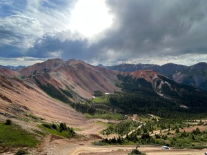
The skies were much clearer than they were the day before, so the fires that had been burning in many places in the western United States must have been dying down.  It definitely made the scenery better.  There are so many colors on this trail, and we took our time enjoying them.

It didn't take us long to get to the scenic stop, and we stopped there for snacks and photos.  It's one of the most scenic spots in the area because of those Red Mountains.  After hanging out for a bit, we started up the hill to the pass.  It's a fun climb!

Before getting to the pass, we turned to do the optional overlook.  We got lucky, and though there were ATVs all over the place we didn't have to get around anyone on the way out or on the way back.  There are some pretty narrow shelf roads on the way out to the overlook, so things could have been a bit scary if we had.

We spent a long time at the overlook, though it was windy.  Niko got his drone out, and it handled the wind like a champ.  We took a ton of photos and just relaxed up there.  We didn't find out until later, but we chose trails for the day that would keep going to high overlooks where we could see the other overlooks we'd just been to.  This was the first of those overlooks, and it's one of our favorites.

We headed back out and down the other side, and it wasn't long before we were at the end and the intersection with Hurricane Pass and Gladstone Road.  We were off to check out more around the old site for Gladstone, so we turned right and headed down.

DSC02139
DSC02140
DSC02141
DSC02144
DSC02145
DSC02146
DSC02147
DSC02149
DSC02150
DSC02151
DSC02152
DSC02154
DSC02156
DSC02158
DSC02161
DSC02162
DSC02164
DSC02168
DSC02169
DSC02173
DSC02174
DSC02176
DSC02177
DSC02178
DSC02180
DSC02181
DSC02182
DSC02184
DSC02185
DSC02187
DSC02188
DSC02189
DSC02190
DSC02191
DSC02192
DSC02193
DSC02195
DSC02196
DSC02198
DSC02199
DSC02200
DSC02201
DSC02203
DSC02204
DSC02205
DSC02206
DSC02207
DSC02208
DSC02209
DSC02210
DSC02211
DSC02212
DSC02213
DSC02214
DSC02215
DSC02216
DSC02217
DSC02218
DSC02219
DSC02220
DSC02221
DSC02222
DSC02223
DSC02224
DSC02225
DSC02227
DSC02228
DSC02229
DSC02230
DSC02231
DSC02232
DSC02233
DSC02234
DSC02235
DSC02236
DSC02239

Reports from Other Days: 3

Use the arrows or dots to flip through the previews of the other reports for Corkscrew Gulch. Click one of them to read more and see all of the photos from that day.

September 20, 2014

Led by Roger R.
We had plans to do four trails in one day, and if all went well we were hoping to get five trails in before the end of the day. So, we left Ouray at about 8:00 in the morning and headed south on highway 550 for the Corkscrew Gulch trailhead….
»
  • 1
  • 2
  • 3
Join Us!
If you aren’t a Member or Subscriber, you can’t see all of the content on this site. Get membership information to see why this site is best when you join and log in

Information for Subscribers

When you log in you’ll see more information here:

  • Recent Community Forum posts
  • Recent polls
  • Upcoming Events you can attend
  • Links to online users

© 2000-2023 · TrailDamage.com · Terms and Conditions · About · Contact
Trail information is only accurate on the date posted. Trails may have changed or closed since that date. Use this information for historical purposes only.
Contact the Forest Service or Bureau of Land Management for up-to-date trail information.

/* ----------------------------------------- */ /* View slug: reports-other-reports-for-same-trail-slider - start */ /* ----------------------------------------- */ /* place the prev/next controls on the sides */ .td-transition-controls .wpv-filter-next-link, .td-transition-controls .wpv-filter-previous-link { border: none; font-size: 300%; position: absolute; top: 70px; } .td-transition-controls .wpv-filter-previous-link { left: 0; } .td-transition-controls .wpv-filter-next-link { right: 0; } /* center the page selector horizonatally */ .td-transition-controls ul.wpv_pagination_dots { text-align: center; margin-top: 10px; } /* center the page selector horizonatally */ .td-transition-controls ul.wpv_pagination_dots li.wpv_pagination_dots_item, .td-transition-controls .wpv_pagination_dots li a { display: inline-block; float: none; } /* remove the default styles */ .td-transition-controls .wpv_pagination_dots li a { text-decoration: none; border-bottom: none; } .td-slider-container { padding: 0 25px; margin-bottom: 20px; position: relative; width:100%; display:table; } .td-slides { position: relative; } .td-slides-image { float:left; display:table-cell; } .td-slides-image img { border:1px solid #c0c0c0; } .td-slides-content { padding:4px 4px 4px 10px; border-top:1px solid #c0c0c0; border-right:1px solid #c0c0c0; border-bottom:1px solid #c0c0c0; display:table-cell; height:227px; overflow:hidden; } .td-slides-content h3 { margin-top:8px; } .td-slides-leader { font-size:smaller; margin-top:4px; } /* ----------------------------------------- */ /* View slug: reports-other-reports-for-same-trail-slider - end */ /* ----------------------------------------- */
/* ----------------------------------------- */ /* Content Template: Template for a Single Report - start */ /* ----------------------------------------- */ .entry-header { display:none; } .entry-content h1 { margin-top:16px; padding-top:0; } h1 a { color:#222; } h1 a:hover { color:#666; } p.entry-meta { font-size:small; } #report-body-spacer { clear:both; width:100%; height:20px; } #addtoany-bar { margin-bottom:2em; text-align:center; } .category-reports .post-info .author, .post-info .date { display: none; } .addthis_recommended_horizontal { text-align:center !important; } /* ----------------------------------------- */ /* Content Template: Template for a Single Report - end */ /* ----------------------------------------- */ /* ----------------------------------------- */ /* Content Template: Loop item in REPORTS Runners - start */ /* ----------------------------------------- */ #runners-container { width:100%; clear:both; } .runner { border:1px solid #c0c0c0; margin:0 6px 6px 0; float:left; width:49%; height:81px; } .runner-image { float: left; } .runner-image img { margin:2px 10px 0 2px; height:75px; width:75px; } .runner-name { text-transform:uppercase; } .runner-name a { color:#222; } .runner-name a:hover { color:#666; } .runner-vehicle { font-size:small; } @media only screen and (max-width: 768px) { .runner { width:100%; } } /* ----------------------------------------- */ /* Content Template: Loop item in REPORTS Runners - end */ /* ----------------------------------------- */