Comb Ridge


Our trip to the Comb Ridge trail was bittersweet. On one hand, we expected the trail itself to be fairly mellow but it ended up being pretty crazy. But on the other hand, the side trails we tried didn't work out in the end. The whole thing didn't go as planned, but it was a blast.
The trailhead was easy to find, heading north off of the pavement at the base of where the highway cuts through Comb Ridge. The trail was easy, and we quickly found our way at the start of the Arch Canyon trail.
We were really looking forward to running Arch Canyon. We had seen it from above at the overlook off of Texas Flat, and we loved seeing arches. We initially took a wrong turn at the start, ending up in a camp site. It was a good place for lunch, though, so we stopped to eat. It was chilly, but at least it wasn't raining. This would be such a good place to spend the night.
We found the actual trail and headed in, driving by a ruin early on. The trail crisscrossed over the low creek at the bottom of the canyon, and it was wet. We dropped in at one spot to follow the creek for a bit before climbing back out.
Then we came to a place where the water flowed along a trench. The sides of the trench were mud with small rocks in it, and the walls were about four feet high. At the end of the trench was a deep section of mud where you had to climb up to the trail. Monica tried it but was stuck right away. There were no trees in front of here to allow her to winch herself forward, and the mud was too deep anyway. Walt was going to have to winch her back out.
Monica couldn't get out, as the trench was the width of her Jeep. Walt walked in muddy water up to his shins to hook his winch cable to Monica's Jeep. It was an easy pull to get her free.
Walt changed into dry shoes and we turned around. Arch Canyon wasn't going to happen for us on that day. When we tried to go through the initial water crossing again, Monica got stuck on the climb out. This time, she had trees in front of her so she winched herself out. This pull took a bit more effort, but she was finally free. Walt didn't have any issues with that muddy exit at all.
We were bummed, but we kept going. We went just a bit farther to start Hotel Rock. We went up to the initial overlook of Arch Canyon, enjoying the climb up slickrock and dirt. We could see the trail below us, but the spot where we had to quit was blocked by the overhang we were on. It was still a bummer.
We went back down the spur and headed up Hotel Rock. The trail was a blast! It was definitely the most difficult trail Monica had been on in her new Jeep, and it was the classic slickrock madness that Walt and Monica both loved.
We got to the infamous place on the Hotel Rock trail where you drive a narrow section that is tippy over a small ravine. We walked it, discussing if we were going to continue or not. We didn't have much daylight left, and the trail was an "out and back" trail so we'd have to drive it again in the dark, most likely. In the end, we decided to head back down and save Hotel Rock for another day.
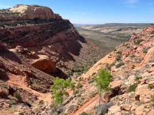
Yet another bummer! But we continued on Comb Ridge, wondering how the climb would be. The trail had been well maintained so far, so we weren't expecting much out of the climb. We were completely wrong.
The climb was a bit intimidating. The trail was narrow and overgrown in places, and it wasn't maintained at all. In some places, a rock had fallen into the trail and we had to drive close to the cliff's edge to get around it. It was nutty, but fun. Someone who didn't like shelf roads would be in their own, personal nightmare, though, as there was always a big dropoff to the side.
We spotted an old car that had come off of the trail. Walt guessed that it was pushed off because it was missing its tires. It was too far down the cliff for someone to steal tires from it after the fact, so it probably went off of the cliff without them.
The climb was crazy all the way to the top. Luckily, we were the only ones on the trail. At the very top, there was a deep trench where the trail was cut right into the rock. It was rough, but a fun section.
We found ourselves on a dirt road again at the top, though it still wasn't maintained. There was a huge crack in the trail that we couldn't get through, so we followed a new trail around it. It looked like that was the answer to trail maintenance.
When we found the trailhead to Posey Trail, our own trail became maintained again. Then we knew it would be a quick ride out to the pavement. We found the cut off to the Tower House Ruins so we took it. We hiked a little distance but the light was fading, so we turned around and headed back to the Jeeps. We didn't see the ruins from where we were, unfortunately. By the time we got back to the Jeeps the sun was completely down and it was dark.
We saw the unmarked trailhead for the Cheese and Raisins trail and then we were at the Cottonwood Wash trail. It was an easy trip back to the pavement from there.
We were soon back in Blanding and we had a great dinner in town at the Patio Drive In. The next morning, we packed up to head home and beat the first winter storm in the Rockies. It was a great trip, and we'll be back to explore the trails we missed.


Report from a Different Day