TrailDamage.com

Photos, videos and information about 4x4 trails in Colorado and Utah

  • Trails
    • Colorado
    • Utah
  • Reports
    • Featured Photos
    • Featured Videos
    • Reports Calendar
  • Members
  • Search
  • Trail Damage Winners
  • FAQ
  • Community
  • Upcoming Events
  • Membership
  • Log In
  • Facebook
  • Instagram
  • RSS
  • Twitter
  • YouTube

Carnage Canyon LHC 061018

October 18, 2006 by Monica

Carnage Canyon LHC

Trail Run on October 18, 2006
Report and photos by Monica I., Trail Leader
View trail information for Carnage Canyon LHC

Monica I.
Red 2010 Jeep Wrangler Rubicon
Don W.
Silver 2005 Jeep Wrangler Rubicon

We decided at the last second that we were going to go run Carnage Canyon. We were only about 30 minutes away, so we hurried through Boulder and up to the trail. We didn't even start it until 5:15PM. It was chilly and snowy and a bit muddy in places, but it was a great run.

We aired down and disconnected, then started up the trail. There were tracks ahead of us, but it looked like they had all behaved themselves, which was nice to see. We followed their tracks the whole way through.

Everything had an inch or two of snow on it, which made it slippery and even more fun. We decided that it was too cold and too late to break anything, so we played it safe for the entire run. We didn't attempt Guardian Rock, and we only played a little in the Squeeze.

We had a few issues in only a few places, but it was all about fun. We didn't use lockers unless we were really stuck, so there was a lot of sliding around. We saw a couple of places where it looked like the people before us had really been stuck, but we didn't have those issues.

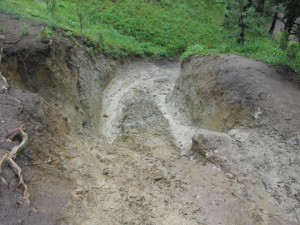
We both just drove right by the Slab. It was slick and wet, and it looked like the people before us had tried it a bit but didn't make it. We decided to skip it for now.

We didn't even attempt the Waterfall -- we went around it like we usually do. It had a lot of snow on it, and a big, icy puddle in the middle. The way around it wasn't too slick.

Because we skipped everything difficult, we got to Five Points pretty quickly. Still, the snow made all of the rocks a bit challenging. Both of us got a little stuck from time to time, but we didn't need any recovery equipment or rock stacking. There were just moments of being stuck.

We came down Left Hand Canyon and didn't mess around on any of the fun obstacles. It was pretty muddy and slick and it was really getting chilly. We aired up and took off, and the whole thing didn't take long at all.

It was a great spur-of-the-moment trip!

don_airing_down
don_and_monica
don_around_the_slab
don_around_the_waterfall_part_1
don_around_the_waterfall_part_2
don_around_the_waterfall_part_3
don_around_the_waterfall_part_4
don_around_the_waterfall_part_5
don_in_the_squeeze_part_1
don_in_the_squeeze_part_2
don_in_the_squeeze_part_3
don_in_the_squeeze_part_4
don_in_the_squeeze_part_5
don_on_a_ledge_part_1
don_on_a_ledge_part_2
don_on_a_ledge_part_3
don_on_a_ledge_part_4
don_on_snowy_rocks
don_on_the_trail
don_trail_damage
monica_airing_down
monica_around_the_waterfall
monica_in_the_squeeze_part_1
monica_in_the_squeeze_part_2
monica_in_the_squeeze_part_3
monica_in_the_squeeze_part_4
monica_in_the_squeeze_part_5
monica_on_a_ledge_part_1
monica_on_a_ledge_part_2
monica_on_a_ledge_part_3
monica_on_a_ledge_part_4
monica_on_snowy_rocks
the_squeeze
waterfall_part_1
waterfall_part_2

Reports from Other Days: 8

Use the arrows or dots to flip through the previews of the other reports for Carnage Canyon LHC. Click one of them to read more and see all of the photos from that day.

June 4, 2005

Led by Bob S.
The day was somewhat chilly, rainy, and dreary as we met in our usual location at the Starbucks on Arapahoe Road in Boulder. Monica stopped by to say hello, and see us off. Ladd had to be convinced to come along, since he was not keen on doing the trail…
« »
  • 1
  • 2
  • 3
  • 4
  • 5
  • 6
  • 7
  • 8
Join Us!
If you aren’t a Member or Subscriber, you can’t see all of the content on this site. Get membership information to see why this site is best when you join and log in

Information for Subscribers

When you log in you’ll see more information here:

  • Recent Community Forum posts
  • Recent polls
  • Upcoming Events you can attend
  • Links to online users

© 2000-2023 · TrailDamage.com · Terms and Conditions · About · Contact
Trail information is only accurate on the date posted. Trails may have changed or closed since that date. Use this information for historical purposes only.
Contact the Forest Service or Bureau of Land Management for up-to-date trail information.

/* ----------------------------------------- */ /* View slug: reports-other-reports-for-same-trail-slider - start */ /* ----------------------------------------- */ /* place the prev/next controls on the sides */ .td-transition-controls .wpv-filter-next-link, .td-transition-controls .wpv-filter-previous-link { border: none; font-size: 300%; position: absolute; top: 70px; } .td-transition-controls .wpv-filter-previous-link { left: 0; } .td-transition-controls .wpv-filter-next-link { right: 0; } /* center the page selector horizonatally */ .td-transition-controls ul.wpv_pagination_dots { text-align: center; margin-top: 10px; } /* center the page selector horizonatally */ .td-transition-controls ul.wpv_pagination_dots li.wpv_pagination_dots_item, .td-transition-controls .wpv_pagination_dots li a { display: inline-block; float: none; } /* remove the default styles */ .td-transition-controls .wpv_pagination_dots li a { text-decoration: none; border-bottom: none; } .td-slider-container { padding: 0 25px; margin-bottom: 20px; position: relative; width:100%; display:table; } .td-slides { position: relative; } .td-slides-image { float:left; display:table-cell; } .td-slides-image img { border:1px solid #c0c0c0; } .td-slides-content { padding:4px 4px 4px 10px; border-top:1px solid #c0c0c0; border-right:1px solid #c0c0c0; border-bottom:1px solid #c0c0c0; display:table-cell; height:227px; overflow:hidden; } .td-slides-content h3 { margin-top:8px; } .td-slides-leader { font-size:smaller; margin-top:4px; } /* ----------------------------------------- */ /* View slug: reports-other-reports-for-same-trail-slider - end */ /* ----------------------------------------- */
/* ----------------------------------------- */ /* Content Template: Template for a Single Report - start */ /* ----------------------------------------- */ .entry-header { display:none; } .entry-content h1 { margin-top:16px; padding-top:0; } h1 a { color:#222; } h1 a:hover { color:#666; } p.entry-meta { font-size:small; } #report-body-spacer { clear:both; width:100%; height:20px; } #addtoany-bar { margin-bottom:2em; text-align:center; } .category-reports .post-info .author, .post-info .date { display: none; } .addthis_recommended_horizontal { text-align:center !important; } /* ----------------------------------------- */ /* Content Template: Template for a Single Report - end */ /* ----------------------------------------- */ /* ----------------------------------------- */ /* Content Template: Loop item in REPORTS Runners - start */ /* ----------------------------------------- */ #runners-container { width:100%; clear:both; } .runner { border:1px solid #c0c0c0; margin:0 6px 6px 0; float:left; width:49%; height:81px; } .runner-image { float: left; } .runner-image img { margin:2px 10px 0 2px; height:75px; width:75px; } .runner-name { text-transform:uppercase; } .runner-name a { color:#222; } .runner-name a:hover { color:#666; } .runner-vehicle { font-size:small; } @media only screen and (max-width: 768px) { .runner { width:100%; } } /* ----------------------------------------- */ /* Content Template: Loop item in REPORTS Runners - end */ /* ----------------------------------------- */