TrailDamage.com

Photos, videos and information about 4x4 trails in Colorado and Utah

  • Trails
    • Colorado
    • Utah
  • Reports
    • Featured Photos
    • Featured Videos
    • Reports Calendar
  • Members
  • Search
  • Trail Damage Winners
  • FAQ
  • Community
  • Upcoming Events
  • Membership
  • Log In
  • Facebook
  • Instagram
  • RSS
  • Twitter
  • YouTube

Cache Valley 121019

October 19, 2012 by Monica

Cache Valley

Trail Run on October 19, 2012
Report and photos by Monica I., Trail Leader
View trail information for Cache Valley

Walt S.
Gray 2018 Jeep Wrangler Unlimited Rubicon
Monica I.
Red 2010 Jeep Wrangler Rubicon
Bill S.
Khaki 2004 Jeep Wrangler Rubicon
Ben P.
Green 2012 Jeep Wrangler Unlimited Rubicon
Roger R.
White 2005 Jeep Wrangler Unlimited Rubicon

The Tower Arch trail in Arches National Park was one of the first trails we ever did in Utah. It was the only Arches trail we had seen, so it was time to see what other trails the park had to offer. We met at the visitor center and then headed into the park, stopping at the Delicate Arch Viewpoint. We walked over to see the arch and take some pictures, but we were looking forward to some wheeling so we didn't stay long. Then we aired down in the parking area, which was handy. We practically had the place to ourselves.

It was odd driving up and over the sidewalk to start the trail, and then it was an easy, dirt road. It was well maintained and easy to follow, and then we came to the gate at the park boundary. We went through and closed it behind us, and then route finding wasn't quite as easy.

In some places the trail followed the wash, bouncing us through little rocks. We were following some 4x4 tracks, and it looked like they didn't know where the trail was half the time, either. We followed their tracks and got turned around a couple of times, but eventually we found our way. The trick was to stay in the wash unless you couldn't, and then take the trail out of it when it stopped you.

The trip along the valley floor was nice, and there were even a few puddles and muddy areas. The green dirt is always weird, and that kept things interesting. It seemed like we were going to have a leisurely drive along this new trail, and we didn't think the loop would take long. We were definitely wrong about that, but in a good way.

The trail started to get interesting as we worked our way over to the climb up to Dry Mesa. We were having a great time on the little hills and bits of slickrock. Monica managed to drag a big rock through the sand at the bottom of the wash, and that was good for a laugh as she worked her way off of it. Then we got to the bottom of Limo Hill and it looked like the trail was about to get difficult.

The 4x4 who was there before us had turned around at the bottom of the hill, and we could see the vehicle's tracks in the sand. That meant that the obstacle was covered in sand and there were no tracks on it at all. It made it difficult to see that it was quite a bit bigger than we originally thought. Monica went first to check it out and report back.

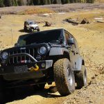
The first part of the hill was a good time, but then Monica got to Limo Wall. She had some momentum going, much more than she needed, and she even felt her front tires get light as she bounced up the hill. She kept cruising and made it to the top in record speed. What a rush!

Bill came next, and he took it at normal speeds. He didn't even have to slow down on his trip to the top. He made the whole thing look easy, but his grin let us know it had taken some effort.

Ben was next, and his trip up the obstacle named it. People call the 4-door Jeep Wrangler a "limo" because it's long and low to the ground. Because of the long wheelbase, it doesn't have a good break-over angle, and that was the issue. He made it to Limo Wall easily enough, but then he couldn't get over it. He kept hitting his frame and skid plates and just couldn't get up it. With help from a spotter he tried a few different approaches but nothing worked. Finally, some strategically placed rocks gave him a chance and he popped right up it. For his first trip to Moab in his new Jeep, things were starting out right! It's always a good time to learn how to do the "Moab bump."

Walt was next up the obstacle, and he made the entire hill look like a dirt road until he found a loose rock above Limo Wall and dragged it around a bit. But he was up the hill in no time.

Roger brought up the rear and he took it slow and easy. Limo Wall was a piece of cake for him. But Roger likes to take a slightly different line than the rest of us so he got creative near the top of the hill, getting nice and tippy. That'll wake you up.

After Limo Hill it was a short drive to the top. We sat at the "T" intersection and practically flipped a coin to decide which way to go. We decided to do the loop in a clockwise direction so we turned left.

We were glad we had a GPS track of the loop, because there were spurs and other trails all over the place. In addition, the track we were trying to follow wasn't always easy to find. But when we came around to the first overlook we found it by using our GPS units and all was well.

The Professor Valley Overlook was kind of a bust. We didn't get very close to the edge of Dry Mesa, so we couldn't see as much as we'd hoped to see. We could see the top of Fisher Towers and a bit of the valley and highway 128, but not much. We didn't stay for too long.

We headed back to the loop and kept on going. We could soon see the Windows Section of Arches National Park in the distance. Then we turned to go out to the other overlook. It was an easy drive out to the Mat Martin Overlook, and we were lucky to get there at lunch time. We stopped and set up our lunches near the edge, just taking in the view. It was really spectacular, and no one wanted to leave.

We had to go, though, because we had other trails to check out before the day was done. The drive along the western side of the loop was really nice, with big views of the park. There was even a slickrock section, and that made Roger happy. It was Ben's first time on a slab of slickrock and he loved it.

We soon found our way back at the "T" so it was time to head down Limo Hill. We all worked our way down it with no issues, having fun with the steep and bumpy descent. It was kind of a bummer when it was over.

The rest of the way out was easier because we knew where the route was. When we got close to the trailhead we could see that the empty parking lot we left was now packed with cars and people. They watched as we popped over the sidewalk and left.

This is now one of our favorite trails in the Moab area. It has a little bit of everyone's favorite bits of Utah. We went back to the Balanced Rock area so we could check out yet another new trail.

across_the_mesa
airing_down
arches_in_the_distance
arches_national_park_part_1
arches_national_park_part_2
ben_after_limo_hill
ben_down_limo_hill_part_1
ben_down_limo_hill_part_2
ben_down_limo_hill_part_3
ben_from_sand_to_slickrock
ben_on_slickrock
ben_on_the_trail
ben_up_limo_hill_part_1
ben_up_limo_hill_part_2
ben_up_limo_hill_part_3
ben_up_limo_hill_part_4
ben_up_limo_hill_part_5
big_view
bill_down_limo_hill_part_1
bill_down_limo_hill_part_2
bill_on_slickrock
bill_standing_on_limo_hill
bill_up_limo_hill_part_1
bill_up_limo_hill_part_2
bill_up_limo_hill_part_3
bluffs
chunky
delicate_arch_viewpoint_sign
delicate_arch
desert_tree
dry_mesa_trail_network
early_climb
flat_spot_down_limo_hill
green_dirt_hill
impassable
jeep_trail
layers
limo_hill_line_up
limo_hill_part_1
limo_hill_part_2
limo_hill_part_3
little_bumps
long_trail
lunch_part_1
lunch_part_2
lunch_part_3
mellow
mit_martin_overlook_part_1
mit_martin_overlook_part_2
mit_martin_overlook_part_3
mit_martin_overlook_part_4
mit_martin_overlook_part_5
mit_martin_overlook_part_6
mit_martin_overlook_part_7
mit_martin_overlook_part_8
monica_and_bill
monica_on_slickrock
monica_on_the_trail
morning_shadows
open_space
professor_valley_overlook
roger_down_limo_hill_part_1
roger_down_limo_hill_part_2
roger_down_limo_hill_part_3
roger_into_the_valley
roger_on_the_trail
roger_up_limo_hill_part_1
roger_up_limo_hill_part_2
roger_up_limo_hill_part_3
roger_up_limo_hill_part_4
roger_up_limo_hill_part_5
roger_wandering_around
sand_and_slickrock
scenic_trail
see_for_miles
slickrock_trail
smooth_and_sandy
stairs
start_of_the_trail
straight_track
the_windows_section
through_brush
through_colors
to_mit_martin_overlook
to_professor_valley_overlook
trail_ahead
trail_in_scenery
trail_in_the_valley
trailhead_sign
trailhead
view_from_limo_hill
walt_and_roger_part_1
walt_and_roger_part_2
walt_down_limo_hill_part_1
walt_down_limo_hill_part_2
walt_down_limo_hill_part_3
walt_down_limo_hill_part_4
walt_up_limo_hill_part_1
walt_up_limo_hill_part_2
walt_up_limo_hill_part_3
walt_up_limo_hill_part_4
walt_up_limo_hill_part_5
wavy
whoopdeedoos
wispy_clouds
Join Us!
If you aren’t a Member or Subscriber, you can’t see all of the content on this site. Get membership information to see why this site is best when you join and log in

Information for Subscribers

When you log in you’ll see more information here:

  • Recent Community Forum posts
  • Recent polls
  • Upcoming Events you can attend
  • Links to online users

© 2000-2021 · TrailDamage.com · Terms and Conditions · About · Contact
Trail information is only accurate on the date posted. Trails may have changed or closed since that date. Use this information for historical purposes only.
Contact the Forest Service or Bureau of Land Management for up-to-date trail information.

/* ----------------------------------------- */ /* View slug: reports-other-reports-for-same-trail-slider - start */ /* ----------------------------------------- */ /* place the prev/next controls on the sides */ .td-transition-controls .wpv-filter-next-link, .td-transition-controls .wpv-filter-previous-link { border: none; font-size: 300%; position: absolute; top: 70px; } .td-transition-controls .wpv-filter-previous-link { left: 0; } .td-transition-controls .wpv-filter-next-link { right: 0; } /* center the page selector horizonatally */ .td-transition-controls ul.wpv_pagination_dots { text-align: center; margin-top: 10px; } /* center the page selector horizonatally */ .td-transition-controls ul.wpv_pagination_dots li.wpv_pagination_dots_item, .td-transition-controls .wpv_pagination_dots li a { display: inline-block; float: none; } /* remove the default styles */ .td-transition-controls .wpv_pagination_dots li a { text-decoration: none; border-bottom: none; } .td-slider-container { padding: 0 25px; margin-bottom: 20px; position: relative; width:100%; display:table; } .td-slides { position: relative; } .td-slides-image { float:left; display:table-cell; } .td-slides-image img { border:1px solid #c0c0c0; } .td-slides-content { padding:4px 4px 4px 10px; border-top:1px solid #c0c0c0; border-right:1px solid #c0c0c0; border-bottom:1px solid #c0c0c0; display:table-cell; height:227px; overflow:hidden; } .td-slides-content h3 { margin-top:8px; } .td-slides-leader { font-size:smaller; margin-top:4px; } /* ----------------------------------------- */ /* View slug: reports-other-reports-for-same-trail-slider - end */ /* ----------------------------------------- */
/* ----------------------------------------- */ /* Content Template: Template for a Single Report - start */ /* ----------------------------------------- */ .entry-header { display:none; } .entry-content h1 { margin-top:16px; padding-top:0; } h1 a { color:#222; } h1 a:hover { color:#666; } p.entry-meta { font-size:small; } #report-body-spacer { clear:both; width:100%; height:20px; } #addtoany-bar { margin-bottom:2em; text-align:center; } .category-reports .post-info .author, .post-info .date { display: none; } .addthis_recommended_horizontal { text-align:center !important; } /* ----------------------------------------- */ /* Content Template: Template for a Single Report - end */ /* ----------------------------------------- */ /* ----------------------------------------- */ /* Content Template: Loop item in REPORTS Runners - start */ /* ----------------------------------------- */ #runners-container { width:100%; clear:both; } .runner { border:1px solid #c0c0c0; margin:0 6px 6px 0; float:left; width:49%; height:81px; } .runner-image { float: left; } .runner-image img { margin:2px 10px 0 2px; height:75px; width:75px; } .runner-name { text-transform:uppercase; } .runner-name a { color:#222; } .runner-name a:hover { color:#666; } .runner-vehicle { font-size:small; } @media only screen and (max-width: 768px) { .runner { width:100%; } } /* ----------------------------------------- */ /* Content Template: Loop item in REPORTS Runners - end */ /* ----------------------------------------- */