TrailDamage.com

Photos, videos and information about 4x4 trails in Colorado and Utah

  • Trails
    • Colorado
    • Utah
  • Reports
    • Featured Photos
    • Featured Videos
    • Reports Calendar
  • Members
  • Search
  • Trail Damage Winners
  • FAQ
  • Community
  • Upcoming Events
  • Membership
  • Log In
  • Facebook
  • Instagram
  • RSS
  • Twitter
  • YouTube

Balanced Rock Road 070804

August 4, 2007 by Monica

Balanced Rock Road

Trail Run on August 4, 2007
Report and photos by Monica I., Trail Leader
View trail information for Balanced Rock Road

Monica I.
Red 2010 Jeep Wrangler Rubicon
Ladd G.
Green 2003 Jeep Wrangler Rubicon
Dane R.
Silver 2007 Jeep Wrangler Rubicon
Dave B.
Black 2004 Jeep Wrangler Rubicon
Walt S.
Gray 2018 Jeep Wrangler Unlimited Rubicon
Don W.
Silver 2005 Jeep Wrangler Rubicon
Steve B.
Green 2000 Jeep Wrangler
Bill S.
Khaki 2004 Jeep Wrangler Rubicon
Todd S.
Silver 2005 Jeep Wrangler Unlimited Rubicon

This trail ended up being a lot more fun because of the downpour we'd been having for quite awhile. We started the trail with the downpour still happening, and the trail was filled with running and standing water. It made for lots of puddles.

The rain let up more and more as we continued. There were some cracks in the road, and those cracks got bigger the further we went, too.

Walt had taken 322A as recently as 2002 to connect to Mount Herman Road, but it was definitely closed. It was pretty overgrown, too. He said it was a fun road and was sad to see it closed.

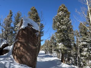
Balanced Rock itself was pretty cool, and we stopped to check it out. It was still raining, though, so no one got out of their Jeep to see it any better. We continued on.

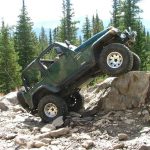
There were a few places that required a good line over the cracks in the road, keeping it interesting. We went by a few more places that featured some cool rock formations and other "balanced rocks," enjoying the scenery. It was quite a descent in places.

The switchback was very tight, requiring reverse from more than a few of us. The trees got closer, and soon we were at the level bottom of the trail.

We stopped at the final gate, at the big campsite. At this point, it was barely raining at all. We got out to stretch our legs, and we talked and wandered around for a bit. It was nice to get a break in the rain, and the timing was perfect. Everything was very green.

It was frustrating to be so close to Palmer Lake and civilization, but we turned around and went back up the trail. It started raining again (or we drove back into the rain) as we climbed. We saw a couple other vehicles, and it wasn't long before we were back on Rampart Range Road. We turned to head for Mount Herman Road and Monument where dinner was waiting.

This ended up being a fun trail, and the campsite at the end was really nice.

322a_closed
aspen_trees
bend
bill_at_the_end
bottom_of_the_hill
climb
cool_rock_1
cool_rock_2
curvy
dane_at_the_end_part_1
dane_at_the_end_part_2
dane_at_the_end_part_3
dave_at_the_end
dave_on_the_trail
don_at_the_end
early_crack_in_the_road
forest_service_sign
gate_number_1
gate_number_2_part_1
gate_number_2_part_2
green
hiking_trail_715
huge_rock
jeeps_at_the_end
ladd_at_the_end
monica_at_the_end
raining
start_of_the_trail
steve_at_the_end
through_trees_at_the_bottom
todd_at_the_end
walt_at_the_end
wet_trail

Reports from Other Days: 6

Use the arrows or dots to flip through the previews of the other reports for Balanced Rock Road. Click one of them to read more and see all of the photos from that day.

November 10, 2018

Led by Matt K.
Balanced Rock Road was going to be the second and last trail to run for the day. 2018 was a good year, and we were sad to see it ending. It was still sunny and warm out when we got to the trailhead. The trail was in very good shape,…
»
  • 1
  • 2
  • 3
  • 4
  • 5
  • 6
Join Us!
If you aren’t a Member or Subscriber, you can’t see all of the content on this site. Get membership information to see why this site is best when you join and log in

Information for Subscribers

When you log in you’ll see more information here:

  • Recent Community Forum posts
  • Recent polls
  • Upcoming Events you can attend
  • Links to online users

© 2000-2021 · TrailDamage.com · Terms and Conditions · About · Contact
Trail information is only accurate on the date posted. Trails may have changed or closed since that date. Use this information for historical purposes only.
Contact the Forest Service or Bureau of Land Management for up-to-date trail information.

/* ----------------------------------------- */ /* View slug: reports-other-reports-for-same-trail-slider - start */ /* ----------------------------------------- */ /* place the prev/next controls on the sides */ .td-transition-controls .wpv-filter-next-link, .td-transition-controls .wpv-filter-previous-link { border: none; font-size: 300%; position: absolute; top: 70px; } .td-transition-controls .wpv-filter-previous-link { left: 0; } .td-transition-controls .wpv-filter-next-link { right: 0; } /* center the page selector horizonatally */ .td-transition-controls ul.wpv_pagination_dots { text-align: center; margin-top: 10px; } /* center the page selector horizonatally */ .td-transition-controls ul.wpv_pagination_dots li.wpv_pagination_dots_item, .td-transition-controls .wpv_pagination_dots li a { display: inline-block; float: none; } /* remove the default styles */ .td-transition-controls .wpv_pagination_dots li a { text-decoration: none; border-bottom: none; } .td-slider-container { padding: 0 25px; margin-bottom: 20px; position: relative; width:100%; display:table; } .td-slides { position: relative; } .td-slides-image { float:left; display:table-cell; } .td-slides-image img { border:1px solid #c0c0c0; } .td-slides-content { padding:4px 4px 4px 10px; border-top:1px solid #c0c0c0; border-right:1px solid #c0c0c0; border-bottom:1px solid #c0c0c0; display:table-cell; height:227px; overflow:hidden; } .td-slides-content h3 { margin-top:8px; } .td-slides-leader { font-size:smaller; margin-top:4px; } /* ----------------------------------------- */ /* View slug: reports-other-reports-for-same-trail-slider - end */ /* ----------------------------------------- */
/* ----------------------------------------- */ /* Content Template: Template for a Single Report - start */ /* ----------------------------------------- */ .entry-header { display:none; } .entry-content h1 { margin-top:16px; padding-top:0; } h1 a { color:#222; } h1 a:hover { color:#666; } p.entry-meta { font-size:small; } #report-body-spacer { clear:both; width:100%; height:20px; } #addtoany-bar { margin-bottom:2em; text-align:center; } .category-reports .post-info .author, .post-info .date { display: none; } .addthis_recommended_horizontal { text-align:center !important; } /* ----------------------------------------- */ /* Content Template: Template for a Single Report - end */ /* ----------------------------------------- */ /* ----------------------------------------- */ /* Content Template: Loop item in REPORTS Runners - start */ /* ----------------------------------------- */ #runners-container { width:100%; clear:both; } .runner { border:1px solid #c0c0c0; margin:0 6px 6px 0; float:left; width:49%; height:81px; } .runner-image { float: left; } .runner-image img { margin:2px 10px 0 2px; height:75px; width:75px; } .runner-name { text-transform:uppercase; } .runner-name a { color:#222; } .runner-name a:hover { color:#666; } .runner-vehicle { font-size:small; } @media only screen and (max-width: 768px) { .runner { width:100%; } } /* ----------------------------------------- */ /* Content Template: Loop item in REPORTS Runners - end */ /* ----------------------------------------- */