TrailDamage.com

Photos, videos and information about 4x4 trails in Colorado and Utah

  • Trails
    • Colorado
    • Utah
  • Reports
    • Featured Photos
    • Featured Videos
    • Reports Calendar
  • Members
  • Search
  • Trail Damage Winners
  • FAQ
  • Community
  • Upcoming Events
  • Membership
  • Log In
  • Facebook
  • Instagram
  • RSS
  • Twitter
  • YouTube

Argentine Pass 180915

September 15, 2018 by Monica

Argentine Pass

Trail Run on September 15, 2018
Report and photos by Monica I., Trail Leader
View trail information for Argentine Pass

Sean C.
Copper 2015 Jeep Wrangler Unlimited Rubicon
Matt K.
White 2016 Jeep Wrangler Unlimited Rubicon
Niko K.
Gray 2017 Jeep Wrangler Unlimited
Chad W.
Red 2014 Jeep Wrangler Unlimited Rubicon
Jim G.
Green 2015 Jeep Wrangler Unlimited Rubicon

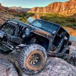
We met at the Downieville Starbucks, and there were other groups of Jeeps there, too.  It made things a bit confusing, but then we all started talking and it was nice to meet other groups and hear about their adventures.  We had a new member join, Jim, and everyone was in a great mood.  We headed up to Georgetown and the trail, airing down at the wide spot in the road before the trailhead.  It was good we did that, because the trailhead was packed with other vehicles.  So, when we got to the trailhead we just headed up the hill.

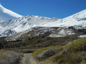
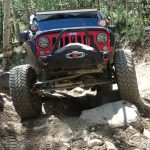
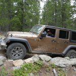
The rocks were good from the start.  Aspen trees were almost completely yellow, though there were still a few green-leafed hold outs.  The sky was clear, and the day was perfect.

When we got to McClellan Mountain, we decided to do Argentine Pass first for a change.  So, we stayed on the main road.  We ended up behind someone for a short while, then they pulled over and we had a clear trail in front of us.

It didn't seem to take long at all before we were at the Waldorf Mine.  We circled the vehicles, and got out to stretch our legs.  There were a few other people around in Jeeps and on dirtbikes, and everyone had a smile and a wave.  We didn't explore too much or for too long before heading up the hill.

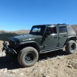
The ledge was fun, and no one had any issues.  At the "Y" we decided to go down to the basin first.  We could see some vehicles on the trail on the way up to the pass, so we thought we'd let it clear out for a bit.  The road to the basin is the roughest part of the trail, but it still isn't bad.  It doesn't seem like the winter and erosion change it very much from year to year.  The views at the end were awesome, with everything yellow and looking like autumn.

We were there for a while, simply because the weather was so nice.  We spent some time getting to know Jim and just hanging out.  But soon we headed back out, looking forward to the pass.

We got lucky, and didn't have to pass anyone on the way up.  When we got to the top, there were a few vehicles and side-by-sides parked almost to the top but not quite, so we lined up at the farthest point.  It was a bit windy and chilly, but we set up chairs for lunch.  This is probably where everyone got their sunburns, high up in the sky with no clouds.  It was a great lunch.

On the way down, we got lucky again and didn't see any oncoming traffic until we were almost back to the mine.  When we got there, we turned to go up the hill and to McClellan Mountain.  It was a great first half of the day.

P1030812
P1030813
P1030814
P1030815
P1030816
P1030817
P1030823
P1030824
P1030825
P1030826
P1030827
P1030828
P1030830
P1030831
P1030832
P1030835
P1030836
P1030837
P1030838
P1030839
P1030840
P1030841
P1030843
P1030844
P1030845
P1030846
P1030847
P1030848
P1030851
P1030852
P1030853
P1030854
P1030855
OLYMPUS DIGITAL CAMERA

Reports from Other Days: 5

Use the arrows or dots to flip through the previews of the other reports for Argentine Pass. Click one of them to read more and see all of the photos from that day.

October 4, 2014

Led by Matt K.
We had a large group of people and Jeeps as we drove through Georgetown and then up to the Argentine Pass trailhead. At the trailhead, a vehicle was parked blocking the trail so the trail was challenging at the start. Once we were all around the vehicle we stopped to…
»
  • 1
  • 2
  • 3
  • 4
  • 5
Join Us!
If you aren’t a Member or Subscriber, you can’t see all of the content on this site. Get membership information to see why this site is best when you join and log in

Information for Subscribers

When you log in you’ll see more information here:

  • Recent Community Forum posts
  • Recent polls
  • Upcoming Events you can attend
  • Links to online users

© 2000-2022 · TrailDamage.com · Terms and Conditions · About · Contact
Trail information is only accurate on the date posted. Trails may have changed or closed since that date. Use this information for historical purposes only.
Contact the Forest Service or Bureau of Land Management for up-to-date trail information.

/* ----------------------------------------- */ /* View slug: reports-other-reports-for-same-trail-slider - start */ /* ----------------------------------------- */ /* place the prev/next controls on the sides */ .td-transition-controls .wpv-filter-next-link, .td-transition-controls .wpv-filter-previous-link { border: none; font-size: 300%; position: absolute; top: 70px; } .td-transition-controls .wpv-filter-previous-link { left: 0; } .td-transition-controls .wpv-filter-next-link { right: 0; } /* center the page selector horizonatally */ .td-transition-controls ul.wpv_pagination_dots { text-align: center; margin-top: 10px; } /* center the page selector horizonatally */ .td-transition-controls ul.wpv_pagination_dots li.wpv_pagination_dots_item, .td-transition-controls .wpv_pagination_dots li a { display: inline-block; float: none; } /* remove the default styles */ .td-transition-controls .wpv_pagination_dots li a { text-decoration: none; border-bottom: none; } .td-slider-container { padding: 0 25px; margin-bottom: 20px; position: relative; width:100%; display:table; } .td-slides { position: relative; } .td-slides-image { float:left; display:table-cell; } .td-slides-image img { border:1px solid #c0c0c0; } .td-slides-content { padding:4px 4px 4px 10px; border-top:1px solid #c0c0c0; border-right:1px solid #c0c0c0; border-bottom:1px solid #c0c0c0; display:table-cell; height:227px; overflow:hidden; } .td-slides-content h3 { margin-top:8px; } .td-slides-leader { font-size:smaller; margin-top:4px; } /* ----------------------------------------- */ /* View slug: reports-other-reports-for-same-trail-slider - end */ /* ----------------------------------------- */
/* ----------------------------------------- */ /* Content Template: Template for a Single Report - start */ /* ----------------------------------------- */ .entry-header { display:none; } .entry-content h1 { margin-top:16px; padding-top:0; } h1 a { color:#222; } h1 a:hover { color:#666; } p.entry-meta { font-size:small; } #report-body-spacer { clear:both; width:100%; height:20px; } #addtoany-bar { margin-bottom:2em; text-align:center; } .category-reports .post-info .author, .post-info .date { display: none; } .addthis_recommended_horizontal { text-align:center !important; } /* ----------------------------------------- */ /* Content Template: Template for a Single Report - end */ /* ----------------------------------------- */ /* ----------------------------------------- */ /* Content Template: Loop item in REPORTS Runners - start */ /* ----------------------------------------- */ #runners-container { width:100%; clear:both; } .runner { border:1px solid #c0c0c0; margin:0 6px 6px 0; float:left; width:49%; height:81px; } .runner-image { float: left; } .runner-image img { margin:2px 10px 0 2px; height:75px; width:75px; } .runner-name { text-transform:uppercase; } .runner-name a { color:#222; } .runner-name a:hover { color:#666; } .runner-vehicle { font-size:small; } @media only screen and (max-width: 768px) { .runner { width:100%; } } /* ----------------------------------------- */ /* Content Template: Loop item in REPORTS Runners - end */ /* ----------------------------------------- */